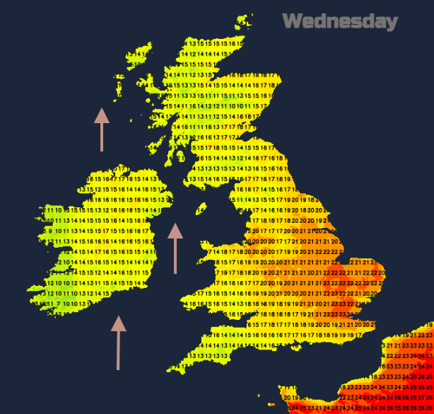
Not as hot as yesterday but still a lot of fine sunshine over the next few days. However, there is a lively band of rain for Northern Ireland this evening and Thunderstorm threat for SE England tonight.
Tuesday saw a top temperature of 27.5C (81.5F) at London Heathrow with a very warm fine day for many before rain over Northern Ireland reached Britain. This gave wild conditions over parts of Scotland through the evening with line convection and sudden gusty winds as the cold front pushed eastwards.
Today it won’t be as hot but still, plenty of warm sunshine about before a lively frontal system reaches Ireland and brings an intense spell of rain to Northern Ireland this evening reaching western Scotland tonight. Separately, showery rain will spill up through SW England and Wales this evening and there will be interest later as the development intensifies and spreads over more of England during Wednesday night.
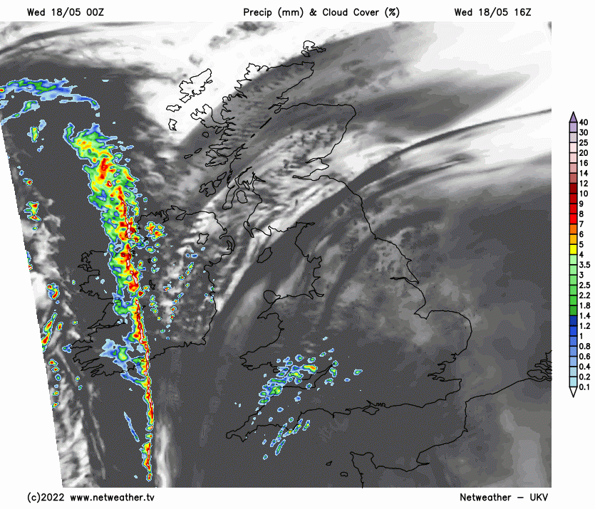
South-eastern England looks most at risk from the thunderstorms with frequent lightning, torrential rain, gusty winds and hail possible. This could lead to localised flooding where drainage systems are suddenly overwhelmed, but the storms are moving through, not stationary which often causes most of the problems. The main bulk of very warm, humid air is over France yet this is a bit more of a threat than the usual skirting/clipping SE England thunderstorm risk. There is wider showery rain forecast over England which will include some heavy downpours tonight and the higher potential of severe weather for SE Britain.
We have the cold front from the west later today, the very warm humid air over France, a shortwave trough approaching southern England this evening and aiding a pulse of the very warm air towards SE England
“Strong instability looks to be released to form clusters of elevated thunderstorms over Normandy and central English Channel areas this evening…these thunderstorms look to expand and then spread NE across central S and SE England and East Anglia later in the evening before clearing eastern England over the North Sea in the early hours.”
More technical detail is available in the Convective Forecast about tonight’s storm development.
“ bowing line segments and perhaps one or two supercell storm structures… Eventually, these storms merging into a linear MCS before clearing. (Mesoscale Convective System) “ Nick Finnis
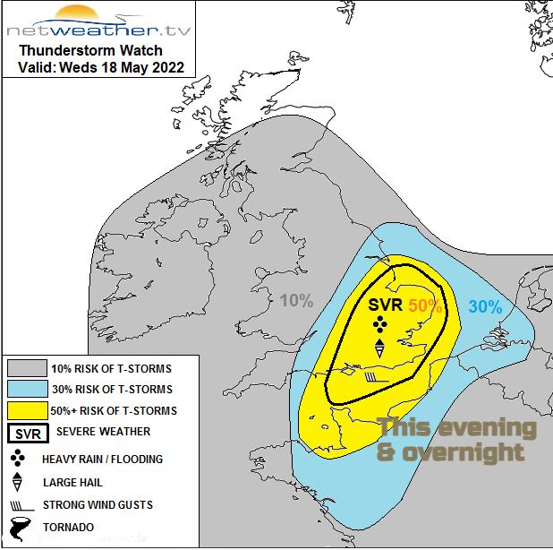
Looking at the chart above, the grey area shows a low risk of lightning, blue and yellow a higher risk of Thunderstorms later today and overnight and within the bold black line there is the potential for severe weather from any storms that do develop. Here is where the large hail, strong wind gusts, frequent cloud-to-ground lightning and intense rainfall potential is significant for the UK.
Do keep an eye on the Netweather Radar this evening to see the showers over the English Channel and remember to toggle Lightning Sferics ON to see the crosses or dots.
It all moves through quite quickly leaving a fresher feel for Thursday morning, particularly for Northern Ireland, Wales and Scotland. Pressure is rising from the south. The far NW of Scotland will see a few showers with a brisk S/SW wind but most of the UK will have a fine, dry day with sunshine and light winds. Temperatures in the mid to high teens, central, eastern and SE England just into the low twenties Celsius. Friday looks fine again before showery rain edges into the far northwest from an occluding front. So, some lively weather tonight but then fine and settled for Thursday and Friday.