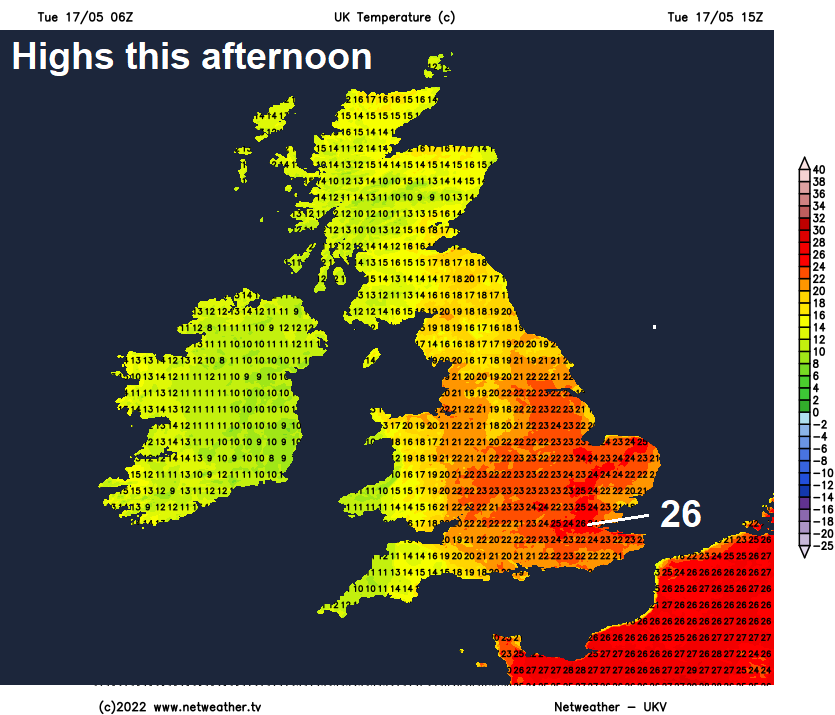
SE England may reach 26C today in the sunshine across many eastern areas. Heavy rain in the west, this will reach the east this evening. More heavy rain, perhaps thundery, later on Wednesday and again Friday, but dry and sunny in between.
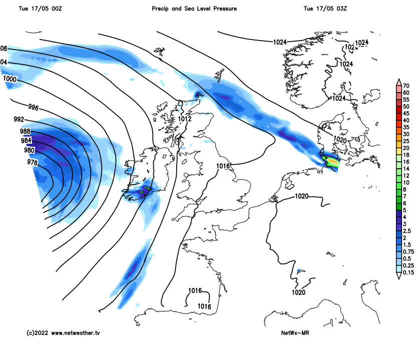
Today will likely see the warmest day of the year so far, as a plume of warm and muggy air spreads north across England and Wales ahead of a cold front moving into the west. Temperatures could reach 26C in the southeast of England, the warmest we’ve reached so far this year was 23.6C in Kent back on the 6th. However, out towards the west, increasingly heavy outbreaks of rain will develop through the day.
Very warm in the east today, but the weather remains changeable, with a band of heavy thundery rain spreading east next few days:
A band of heavy and perhaps thundery rain will clear eastern areas later this evening, then a brief ridge of high pressure will bring a mostly dry, warm and sunny day again on Wednesday, before more heavy rain moves in across the west through the afternoon, while some thundery showers move in across the south in the evening. Thursday’s looking quite promising, as another ridge of high pressure brings a mostly dry and sunny day, but it will not be as warm as today. Friday looks like turning unsettled again, with cloud and rain spreading northeast across many parts.
For now, a cold front will slowly and erratically move in across western areas through the day, with cloud and outbreaks of rain affecting eastern Ireland, N. Ireland and through the Irish Sea turning increasingly heavy through the morning from the south, as waves ripple north along the front. This heavy rain edging slowly east into SW England, Wales, NW England and western Scotland too through the afternoon, perhaps with the odd rumble of thunder. Rain heavier enough to bring some localised surface water flooding. Rain clearing western Ireland and the west of N. Ireland through the afternoon, to be replaced by sunshine and showers.

A different story further east though, with eastern Scotland, central and eastern England seeing a warm and sunny day, very warm and humid across eastern England with a warm southerly breeze, temperatures likely to reach 26C in the southeast and London area, 21-24C elsewhere across central and eastern England along with south Wales. 15-18C under the cloud and rain in the west.
Band of heavy and squally rain along the cold front clears north and east this evening, perhaps with thunder across eastern England, before the front exits the east coast around midnight. Then becoming dry with clear spells for most in the early hours, though showers will linger across the northwest.
Still a few showers to start across western Scotland, otherwise a dry and sunny morning for many on Wednesday. Showery and perhaps heavy rain then looks to arrive across the west in the afternoon before spreading eastwards through the evening, while an area of thunderstorms look to develop over the English Channel and push across SE England during the evening too. Staying warm and sunny across eastern areas through the afternoon though before rain arrives in the evening, temperatures here reaching 19-23C, 16-19C in the west.

Heavy rain for a time Wednesday night, perhaps some thunderstorms across SE England and East Anglia, before clearing in the early hours. Then following will be a mostly fine, sunny and dry Thursday, the cold front clearing in the early hours will usher in cooler and fresher Atlantic air, so not as warm as today and tomorrow. Temperatures reaching 17-22C.
All change again on Friday, after a dry and bright start, an occluded frontal system moving in from the west will bring increasing cloud and showery rain, perhaps heavy and thundery in places, across many areas into the afternoon, small chance of thunderstorms clipping the far southeast too.
The weekend looking around average temperature-wise, with a westerly or southwesterly breeze that will bring varying cloud amounts with occasional showers in the north and west, best of the drier and sunnier weather towards the southeast.