A fine Saturday with high pressure over the UK, light winds and warm sunshine. A more complicated picture into Sunday with potential for showers even storms but fine again for many.
This weekend there will be plenty of dry weather across the UK, light winds on Saturday with high pressure overhead. If you have heard talk of heat heading our way that is still in the forecast but more for Monday/Tuesday, but the weekend should see temperatures widely well up in the teens and tipping into the low 20s Celsius. More of an easterly breeze could pick up for Sunday and there are signs of a few heavy, even thundery showers breaking out, but confidence is low around those.
Friday evening looks fine for many but still a westerly breeze and not that warm once the sun disappears. The weekend starts with high pressure to the south of the UK, settling the weather down and allowing the blustery winds to ease. To the north, low pressure moves away to Lapland and the colder air over the far north of Scotland drifts away. It will be quite cool overnight across the UK with many places seeing temperatures fall down into single figures. Southern and eastern Britain will have clear spells but there will be a bit more cloud further west with patchy rain and damp conditions just clinging on for NW Scotland.
The high pressure sets to work on Saturday, settling the weather down and subduing any lingering showers in the far northwest. It will be a fine, dry day with warm sunny spells. More sunshine for England and Wales a bit more cloud and bright picture rather than total sunshine further north. Northern Ireland and northern England should see more sunshine by late afternoon and for the evening.
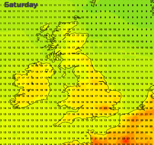
Scotland and Northern Ireland should see temperatures of 15 to 19C with very light winds. Wales will see 16 to 20C and England in the mid to high teens with the Midlands, London and Home Counties reaching into the low twenties Celsius. Sunday looks to see a shift in the warmest areas if an easterly breeze picks up. With the sea still cool at this time of year the air won’t feel as warm especially where there is more cloud.
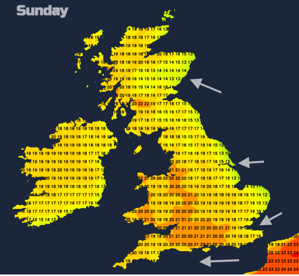
The forecast for Sunday becomes more tricky. Overall, there will be a lot of settled fine weather, again warm in the sunshine. However, the various models are throwing in clusters of heavy, thundery showers. Some forecast to move up from the English Channel on Saturday night across southern Britain, heading northeast with only a few reaching north Wales and northern England.
The Met Office model keeps the threat mostly over northern France with more cloud and a few showers skirting southern England, maybe to Greater London, possibly Essex and Suffolk by the afternoon.
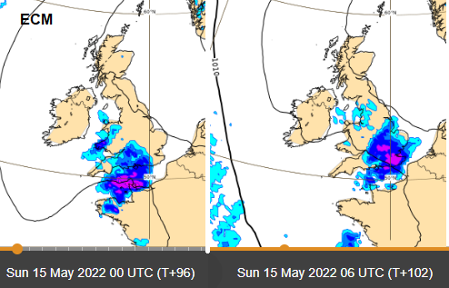
"Looks like weekend may see our first 'plume' of the year with potential for elevated thunderstorms this weekend as the elevated plume is overrun from the west by cold air aloft - though where exactly seems to vary between models" Nick Finnis
Both models seem keen for a pulse of heavy showers to move up from France on Sunday night as a low pressure out in the Atlantic begins to make its presence felt. The rain and potentially thunderstorms force northwards to SE England and East Anglia as the very warm air from the south begins to arrive. This could bring some intense downpours and the risk of localised flooding but currently, confidence is low on the details.
Further discussion and chat in the Netweather Forum