Wednesday's rain will clear eastwards with some sharp showers following. Becoming dry for many away from NW Scotland. Looking interesting weather-wise for the start of the new week.
This week has become rather mixed with blustery showers whisking in from the west and sunny spells and then areas of frontal rain affecting England and Wales. The southeast is still missing most of the rain. Temperatures started the week reaching 23C, but cooler air will reach into the north. There are signs of rising temperatures early next week and potentially thunderstorms.
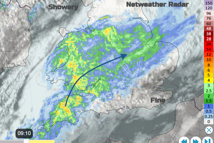
Ongoing conveyor of rain from the southwest today, slightly waving north earlier but will move bodily eastwards through Wednesday
Today a flattened frontal wave has nudged up over Wales bringing a wet start to Wednesday. Powys has a little more shelter from this feed of wet weather from the southwest. The rain is more patchy as it reaches into Yorkshire but there is quite a feed from north Devon across to the Wash. The whole lot edges eastwards through the day, over East Anglia SE England this afternoon with sharp showers developing for the Midlands and Lincolnshire after lunch.
There is a low pressure quite happily sitting north of Scotland and this continues to feed showers into NW UK. There are clusters of heavy showers then brighter skies and again today the risk of hail and lightning.
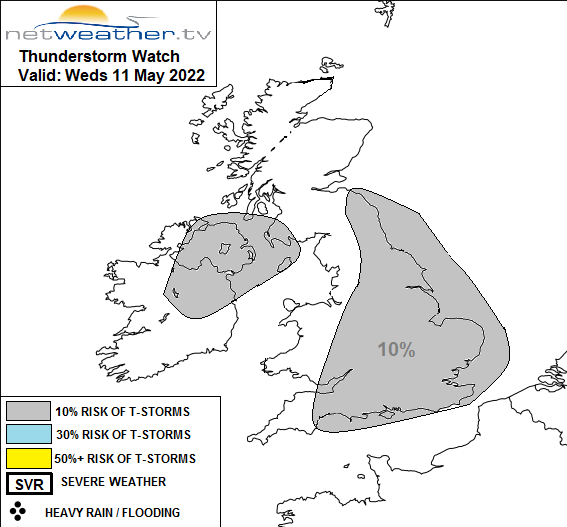
Convective forecast thunderstorm risk areas for 11th May
For the rest of the working week, the Azores high tries to reach our way and does suppress the shower activity for southern Britain with some warm sunshine. However new low pressures move by between Scotland and Iceland with blustery winds, the cooler air and more showers or frontal rain.
After today’s rain, many parts of the UK will be dry into the weekend. Western Scotland will see more rain, there have been concerns on the West Highland Line after ongoing heavy rain with speed restrictions in place. The NW Highlands into Argyll, Western and Northern Isles continue to see rain and blustery winds. There will be showers reaching Northern Ireland, more of Scotland but sheltered in the east and thicker cloud for Cumbria and western Wales. It will be windy with a brisk westerly wind.
By the weekend most places will be dry and fine with lighter winds, still from the west but feeling warmer in the bright or sunny weather. High pressure will be right over the UK on Saturday but slips over the North Sea by Sunday. The models vary but as the surface wind turns to the east, so cooler along coasts in that, there are signs of heavy showers appearing. A few ingredients for thunderstorms near to southern/SE England are there but low confidence about timings, location and even likelihood. The ECM shows a lot reaching across the Channel on Saturday night, MO brushing past SE early Sunday and the GFS nothing until early Monday.
Today temperatures will be 13 to 18C and depending on the rain and cloud cover in southeast England there could be the odd spot going higher. The light to moderate SW winds veer to the west as the rain clears but with gusty winds in any heavier showers. Scotland will have a moderate to fresh west wind, strong at times in the far north.
Cooler air arrives from the northwest tonight. Tomorrow many places will be in the mid-teens, but SE Britain could move up a few degrees with longer sunny spells and a dry day.
Similar on Friday although colder air skirts past the far north of Scotland and it will be a cool night across the UK, for anyone camping this weekend. Temperatures down into single figures.
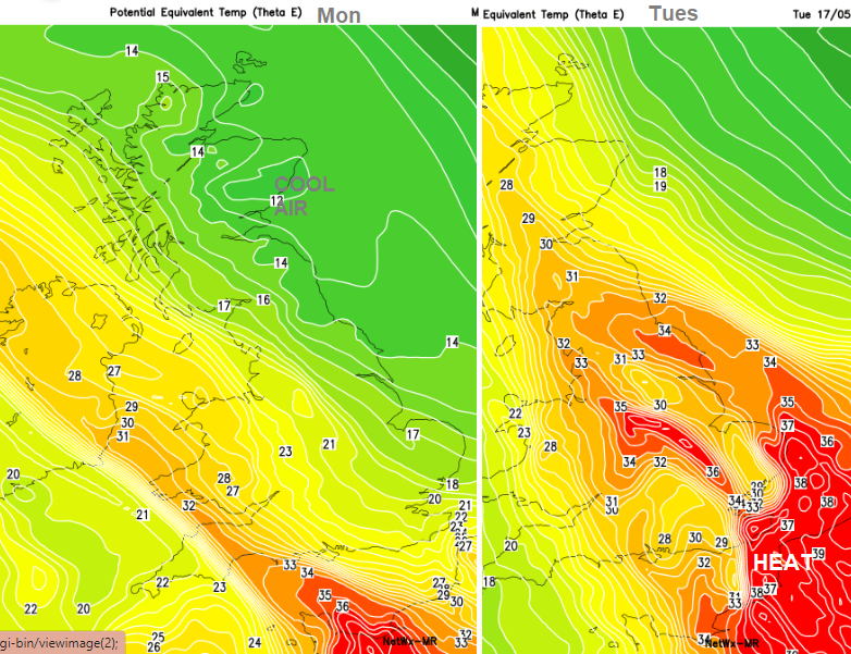
Warmer everywhere on Saturday with hardly any breeze, sunshine and temperatures in the high teens and low twenties. Although there will be the easterly flow on Sunday there does look to be hotter air moving up from France early next week, lifting the temperatures well up into the 20s C.
It might not last for long, but Tuesday looks much warmer right through Britain.