


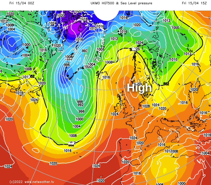
Atlantic fronts just to the West will make only slow progress eastward through the Easter break, leaving much of the extended holiday weekend fine with some warm afternoons across most of the country.
Atlantic fronts just to the West will make only slow progress eastward through the Easter break, leaving much of the extended holiday weekend fine with some warm afternoons across most of the country. A few showers in the West may occur more widely by Monday as high pressure associated with an anticyclone to the East begins to leak away. It'll also be turning somewhat cooler from the West.
It's a grey, misty start around the Irish Sea, towards the South coast and along some shorelines of East Scotland and North East England that could take a while to clear. A weak front is also giving mostly light rain across the North of Scotland that'll peter out, as will early drizzle across parts of Northern Ireland. But for most, it'll be a fine Good Friday with lots of sunshine to enjoy, spoiled just occasionally by varying amounts of medium and upper-level cloud. While a few showers will crop up over Northern Ireland, the North and West of Scotland and in the far the West, the bulk of the country will be dry,
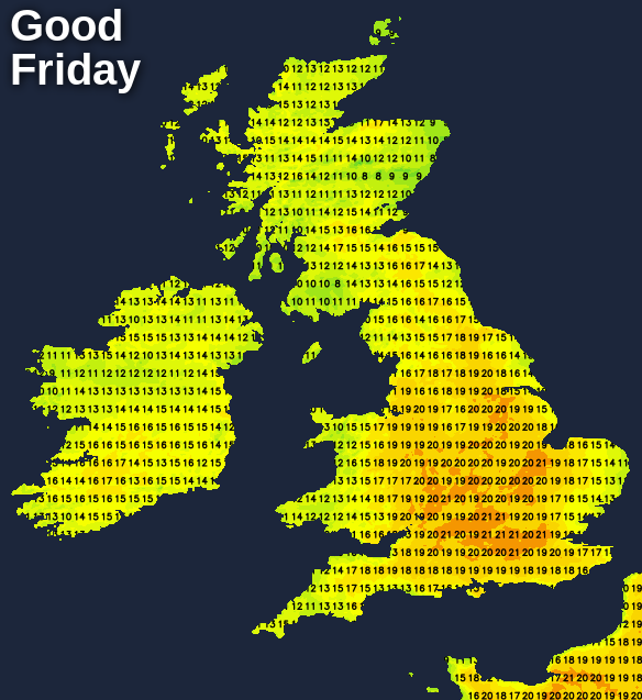
With primarily light breezes from a southerly quarter, it'll become warm where you see the best of the sunshine. Temperatures reach 15 to 19C quite widely, with 21 or 22C possible across parts of East Anglia and South East, making it the warmest day of the spring so far for some. However, it'll be cooler in the far North and West, with 12 to 14C more likely here.
Northern Ireland and the North and West of Scotland may continue to see a few showers or some drizzle after dark, but it'll be a fine, dry evening and night for most. It'll turn misty again in places in light South Easterly breezes with patchy fog and low cloud returning, the latter chiefly in coastal areas. But in a mild frost-free night, temperatures fall no lower than 4 to 8C.
As a general rule, the further West you are on Saturday, the more likely you are to catch a shower. But for most, it'll be another dry, fine day once morning mist, patchy fog and low cloud have cleared. The best of the sunshine should be in southern and eastern areas, while Northern Ireland and the far West tend to see more in the way of cloud and a few showers. Here, a southerly breeze may freshen a little later, but winds continue to be light in most parts. Another warm afternoon is expected in the sunshine, with maximum temperatures of 18 to 20C but only 13 to 16C further West.
Northern Ireland and the West and North West of Scotland may see it turning more generally unsettled with bursts of rain moving in overnight on a freshening southerly wind. Elsewhere, apart from the odd shower in the far West, it continues dry with clear spells. Lighter breezes here allow mist, patchy fog and low cloud to return in another generally mild night, with lowest temperatures mainly in the range of 5 to 8C.
Looking further ahead into next week, it's a cooler prospect, as winds eventually turn into a North Easterly quarter. There'll be scattered showers but some sunshine as well, this mostly in more sheltered western areas.


