Temperatures are on the rise, up to 20C midweek as the brisk SE wind eases. Not a washout but bands of heavy rain then thundery showers will interrupt Tuesday.
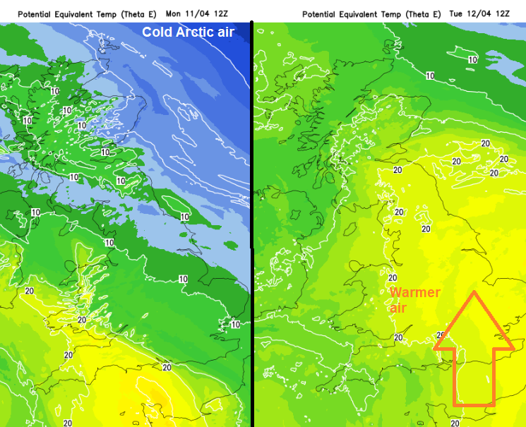
The start of April has been cool, even chilly with a cold Arctic flow. All change as an Atlantic low pressure looms and begins to feed up warmer air through western Europe. This looks to peak in the middle of the week with temperatures in southern England reaching 20C.
There will be more cloud this week with outbreaks of rain. There are already thundery bursts over the tip of Cornwall for Monday morning. And at times it will be blustery. So milder air and less chance of a frost but more unsettled weather as the Easter Holidays really get going. It’s not a wash out although there will be a band of heavier rain working its way up through the UK early on Tuesday.
Warm air being pulled up around the low and little frontal feature moving up from Bay of Biscay tonight
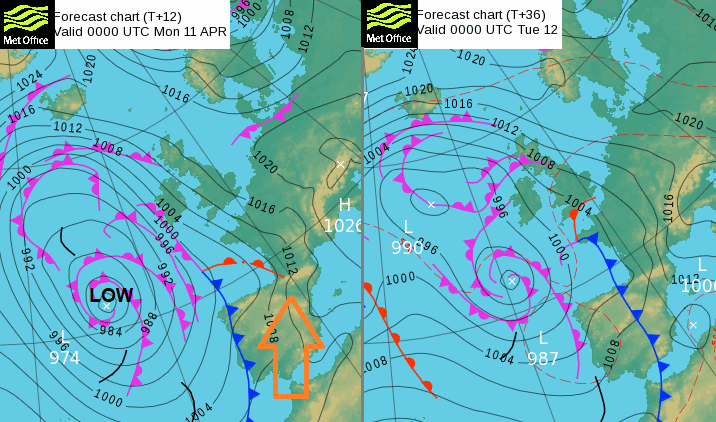
The dominating low pressure out in the Atlantic was once Storm Evelyn, named by the Portuguese Met Service for high winds over the Azores. It is slow-moving and has filled but will continue to steer weather and warm air from northern Africa through Spain and France towards the UK. Saharan dust is once more airborne, and the particulates will affect air quality this week. Meteo France mention the Autan wind in their forecast, a strong SE wind which brings warm air but also a noise over the hills. When it persists for southern France and is violent it is said to make people crazy.
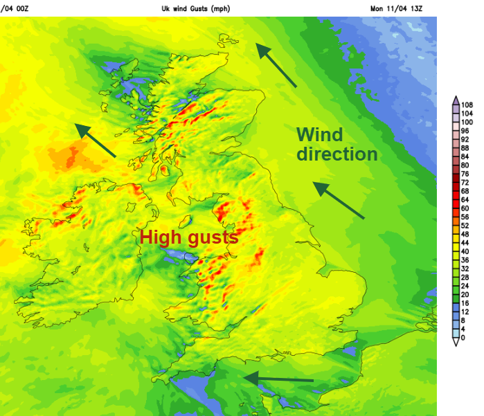
For us in the UK, there will be more of a wind in the coming days, with high lee gusts. Today in the east to SE wind it will be gusty over the Welsh mountains and then over the tops of hills and to lee of high ground for western Britain and County Londonderry. The gusty SE wind continues for Scotland this evening as the winds ease further south in Britain and then for all by Tuesday. The calmer conditions will aid the warmer feel to things.
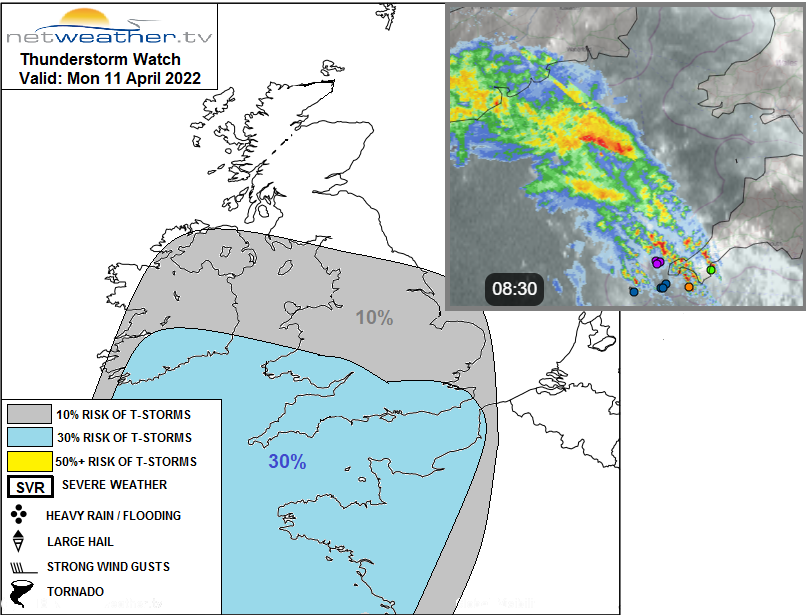
There is a thunderstorm watch for today and overnight as the warm, moist plume of air moves up from the south but with lift over the cooler surface air over the UK.
“mid-level instability initially across SW England, Wales, Irish Sea, NW England and Ireland through the morning, with some mid-level convections from Ac Cas bringing some heavy showers and a few elevated thunderstorms here through the morning… This mid-level convective activity, with isolated heavy showers, could spread further east across England through the day too – as the edge of the elevated plume advances further north.”
Ac Cas is Altocumulus Castellanus, the mid-level cloud that looks like battlements. Undulating Asperitas has also been reported in the Southwest and jellyfish-like clouds with their dangling virga. The bands of rain, with not much reaching the surface yet the risk of lightning, brush past Wales and reach Northern Ireland this afternoon and evening, into SW Scotland later with some heavier bursts.
Temperatures today will widely be 11 to 16C. In any sunny breaks, a few spots along the M4 or for London could see 17C maybe 18C. In any sunshine it will feel warm but North Sea coasts keep a cooler breeze off the sea, with temperatures north of the Humber 7 to 11C by the seaside.
The mild conditions remain overnight but with more cloud and murk about. Today’s showery rain progresses northwards over Scotland later today with some heavier rain as the cold air still clings on for the Northern Isles. Temperatures in Shetland stay in single figures this week.
During tonight another area of showery rain arrives in the south, with the risk of some heavier downpours, thunder and lightning. There are timing differences on the progress of the little warm front northwards. The UKV has the main area across Wales and southern England before dawn so a wet start Belfast, north Wales, northern England and soon southern Scotland. Reaching the Central Belt in the morning. This frontal rain will continue to northern Scotland in the afternoon as the cold front trails down through England with some uncertainty about positioning and timings. The convection is elevated to start with there will be surface based convection set off in the afternoon with the warm, moist air. More cloud about so that might inhibit the top temperatures within the warm sector zone but gaps to the west in the afternoon could trigger CBs.
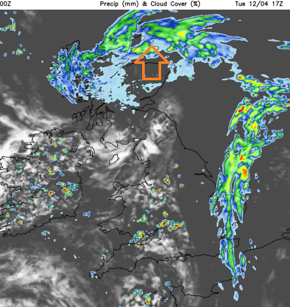
The GFS model has the main rain band a bit slower on Tuesday morning with heavy, thundery downpours included. Both show heavy showers and thunderstorms breaking out over Ireland and then SW Britain and the West Midlands behind the front into the evening.
Mild nights and temperatures lifting towards and around 20C for the middle of the week in the south.
Storm and convective weather discussion in the Netweather community forum