Grey and cold for many today, a little rain in the far north where it'll be milder. Wet and windy weather sweeping Scotland later on Wednesday, then a change to a breezier and milder end to the week. Changeable through the weekend.
It will be another grey day for many today, cold too across England and Wales where there’s no sunshine and very little wind under high pressure. A southwesterly breeze will bring somewhat milder conditions to Scotland and N. Ireland, while a weather front will bring some rain to far northwest. Wednesday will see high pressure retreat south, this will allow the flow to come off the Atlantic across all areas for the rest of week, so it will turn progressively milder for many. A deep low passing close to the Shetland Isles later tomorrow will bring a spell of wet and windy weather to Scotland. A weakening cold front clears southeast on Thursday, reaching the south early afternoon, bringing cloud and some patchy rain, brighter skies following but with showers across the far north and northwest. Friday is looking cloudy once again for many but mild, wet and windy weather returning to Scotland, drizzle over western hills further south.
Back to this morning, and it’s cold across much of England and Wales, some pockets of frost here and there where breaks in the extensive cloud have developed overnight across Yorkshire, The Midlands, NW England and Wales, with temperatures around freezing at breakfast time. Otherwise, for much of England and Wales it will remain gloomy for much of the day under an extensive and featureless blanket of cloud. The combination of cloud and light winds and low temperatures overnight means there’s very little impetus for it to warm up through the day, so it will be rather chilly for many. Best chance of some brightness or even some sunny spells likely across NE England. Temperatures reaching 3-6C at best, perhaps 7-8C in the far west.
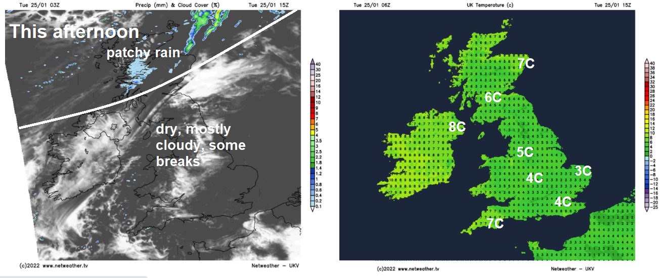
For southern Scotland and N. Ireland, less cold here and generally cloudy but dry today, though there will be some sunshine across NE Scotland and perhaps northern coasts of N. Ireland. Patchy rain across the far NW of Scotland this morning will pep up and become more extensive across northern Scotland through the day with a strengthening southwesterly wind and here we’ll see the highest temperatures, reaching 9-10C, otherwise 7-8C.
Generally cloudy tonight, some patchy light rain or drizzle working its way southeast across Scotland along a weakening front before fizzling out, windy across the far north. England and Wales largely dry with light winds but chilly overnight, where clear spells develop a risk of patchy frost developing.
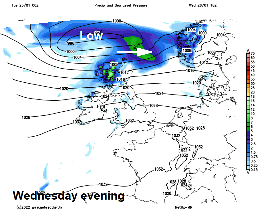
Largely cloudy again on Wednesday, but with a southwesterly flow developing across all parts, it will be less cold across England and Wales than the last few days. For England and Wales it will remain mostly dry and there may be some bright or sunny spells developing through the day towards the east or east of high ground in the west. But after a dry morning across Scotland and N. Ireland, away from western coasts, the southwesterly wind will strengthen and it will turn wet and windy from the west through the afternoon, though not much rain may reach eastern coasts. Temperatures reaching 6-9C generally, perhaps 10-11C across northern Scotland.
Wind gusts Wednesday night (credit: wxcharts.com):
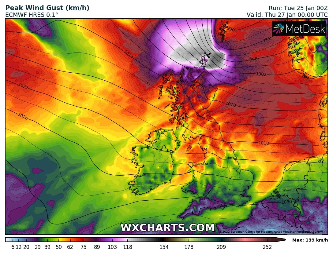
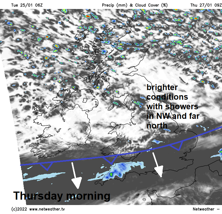
It’s looking to turn very windy across the Northern Isles and far north of mainland Scotland Wednesday evening and night, as deep area of low pressure pass close to Shetland before tracking into Scandinavia. Severe gales possible for a time. Meanwhile, a cold front associated with the low will sweep southeast across England and Wales Thursday morning, bringing a band of patchy rain with it, clearing southern England early afternoon. Brighter skies following across northern and central areas in the morning and southern areas late afternoon. Showers for northern and western Scotland – where it will be windy, breezier elsewhere too and milder for all, temperatures reaching 7-10C in the north, 11-12C in the south.
We stay in the milder air off the Atlantic for Friday, but it’s looking cloudier for most. Rain looks to push in from the west across Scotland through the afternoon, perhaps reaching N. Ireland and far north of England too after dark. But for much of England and Wales it’s looking largely dry, some sunny spells in the east possible, but thicker cloud over western hills may bring some drizzle.
Weekend looking increasingly unsettled and windy across all parts, with a frontal system moving southeast on Saturday bringing some rain to many areas, though perhaps not much for the south, followed by clearer skies and showers from the north. Sunday may start dry and fine, but wet and windy conditions may spread from the west through the day, perhaps with snow this time over northern hills, as cold air digs in from the northwest behind the low bringing the rain.