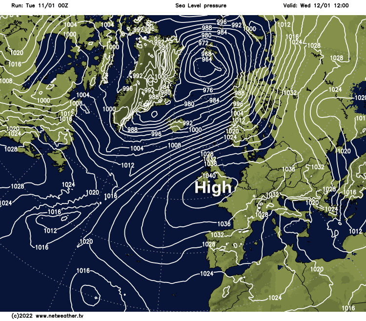
High pressure is now going to dominate the UK's weather. So it'll be mostly dry and settled but with varying amounts of cloud, along with fog and frost patches.
Amidst all the chaos, the weather has peculiarities that tend to occur about the same time each year. They're known as singularities, one of which often brings an unsettled start to January, especially around the 6th to 8th. But a strong pressure rise is now paving the way for the next singularity that occurs from mid-January until about the 24th, which often brings a settled spell. So don't be surprised if these conditions dominate for the next fortnight. If only long-range predictions were that simple!
Today though, we have weakening troughs moving slowly South across England and Wales, giving grey, misty weather with patchy fog. There's also light rain and drizzle in places, mostly across central and southern parts. Further North over Scotland and Northern Ireland, it's finer with some sunshine, this spreading to Wales and the North and West Midlands through the day. Apart from a few showers, mainly over Highland and in the far North, it'll be dry.
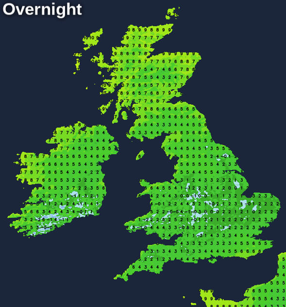
A southwest wind will be fresh across the far North and North West, with a much lighter Westerly breeze further South. After an early frost over some sheltered parts of East Scotland -4C at first at Aboyne, it'll end up a mild day, with top temperatures in the range of 6 to 11C.
Cloudy, damp weather eventually clears from East Anglia and the South after dark to leave clearing skies. This'll lead to a colder night as pressure rises strongly over much of England and Wales. Here there'll be a slight frost with patchy mist and fog forming towards morning in light breezes, as temperatures fall to between -2 and +4C depending on cloud cover. Over the North and West of Scotland and Northern Ireland, it'll be milder with a South West wind continuing to bring a few showers to the far North, where the thermometer may not fall below 8 or 9C.
With a large anticyclone dominating, particularly in the South, most parts tomorrow remain settled and dry. The exception will be Scotland, where a southwest wind will be fresh in the North, bringing cloud and mostly patchy rain to these parts. There'll be some patchy cloud further South but also sunny spells in most regions, and where you see the best of these, it'll become pleasantly mild in lighter breezes, with maximum temperatures between about 8 and 10C. Where mist and patchy fog is slow to clear, however, it'll be colder, with temperatures struggling to reach 4 or 5C.
Things remain much the same after dark, with the breeziest weather over Scotland where a South West wind remains fresh across Highland and the North. This'll also bring a few showers, but it continues dry and settled in light breezes across the bulk of the country. There'll be patchy cloud but also clear spells, with areas of mist and patchy fog reforming. A frost is likely where skies remain clear, with the lowest temperatures in the range of -3 to +3C. But it'll be milder across Highland and the far North, where the thermometer may not fall below 7 or 8C.
Expect little change for the remainder of the week that'll be mainly dry, with mist, patchy fog and night frost becoming more extensive central, southern and eastern parts. Colder here too and gloomy at times but with some sunshine occasionally. However, the mildest weather will continue to be reserved for the North, with the North and West of Scotland continuing to see a few showers.