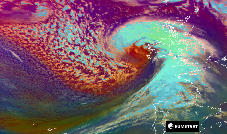
Storm Barra has arrived over Ireland after explosive deepening during the night. A look at the warnings and which areas will see the wild winds, rain and snow as this low churns eastwards.
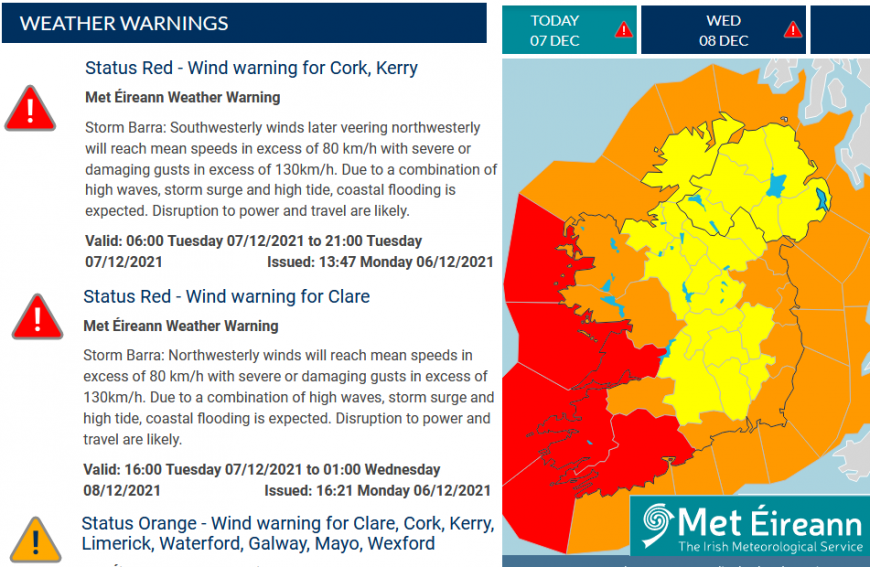
Storm Barra was named earlier this week as Met Eireann issued amber and yellow warnings for the strength of the winds around this rapidly deepening low pressure. It is undergoing “explosive cyclogenesis” out over the Atlantic and on Tuesday 6th red wind warnings were issued for Counties Cork, Kerry and Clare with schools shut today. Storm Barra is expected to bring severe and damaging wind gusts in excess of 130km/h (80mph). The risk of falling trees and power lines with flooding is being highlighted and that driving conditions could be dangerous.
“Very strong winds in combination with high tides means there is a risk of large coastal waves and coastal flooding, particularly along southern and western parts of the country." Met Eireann
The warnings continue over Ireland into Wednesday and after Britain and Northern Ireland has yellow warnings for rain and wind but also snow, mainly over northern hills.
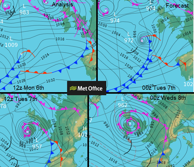
Explosive cyclogenesis “a low pressure system whose central pressure falls 24 millibars in 24 hours” Met Office
1009 down to 957, that is 52 millibars in 24 hours. Barra certainly is a weather bomb.
The red marine warning off the coast of Ireland mentions Violent Storm force 11 with huge dangerous waves coming onto the west coast. The Irish coastguard has issued a warning for Storm Barra, reminding people to “Stay back, Stay high, Stay dry”
“Walkers are advised to avoid any exposed areas, including seafront and cliff walkways, as they may be hit by sudden gusts, exposing themselves to unnecessary danger. All other forms of open water recreation should be avoided, including by experienced practitioners.”
Met Eireann “Storm Barra will bring strong to gale force winds & heavy rain today, southeast to south this morning, & north westerly this evening. Damaging gusts, coastal flooding is likely. Snow & sleet with highs of 5 to 7 degrees. Strong winds will continue through until Wed.”
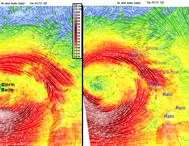
As the centre of Storm Barra arrives over western Ireland, it will be quieter here in the middle of the storm. Co. Kerry and Cork will be battered by the SW then westerly winds and high gusts. Conditions deteriorate in the Irish Sea and for Belfast and Co. Down and Antrim in the strong SE winds as the frontal band of heavy rain hits the cold air and snow begins to appear.
Northern Ireland has a yellow warning for wind and rain from today until 9am on Wednesday. There will be coastal gales, even severe gales and horrible conditions with some disruption to ferry services possible.
“Winds will gradually back easterly, peaking during Tuesday afternoon and evening before gradually easing. Gusts of 45-50 mph are expected widely, with 65-75 mph in exposed coastal locations. “MO
Wales is under two yellow wind warning today, one inland and one coastal.
“Storm Barra will bring very windy conditions to western UK with severe coastal gales.” MO
The coastal one extends over SW England and along the English Channel coastal counties. “bringing severe gales to coastal areas, for a time before starting to ease during Tuesday evening. South to southeast winds will gust to 70-80 mph at times across exposed coastal areas and widely 50-60 mph inland.”
As Barra centres itself over Ireland, the frontal band of heavy rain and hill snow moves eastwards over Britain. Showers follow behind. It becomes wild for the south and west coasts of Wales this afternoon. Again, care is needed, and travel disruption even interrupts to power supplies are possible.
By this evening the stormy conditions will have extended north to the coasts of Co. Clare, Mayo and Galway. Wild here by this evening as Barra continues to rage. The veering winds, turning to the NW will batter Co. Kerry too as a strong SE wind hits the east coast of Scotland with ongoing rain and hill snow. Conditions on the roads will be difficult and some trees and structures are still precarious after Storm Arwen. That caused so much damage because of its strength but also being from an unusual direction. Northerlies like that don’t happen very often. Storm Barra comes from a more traditional direction but is still quite the low pressure.
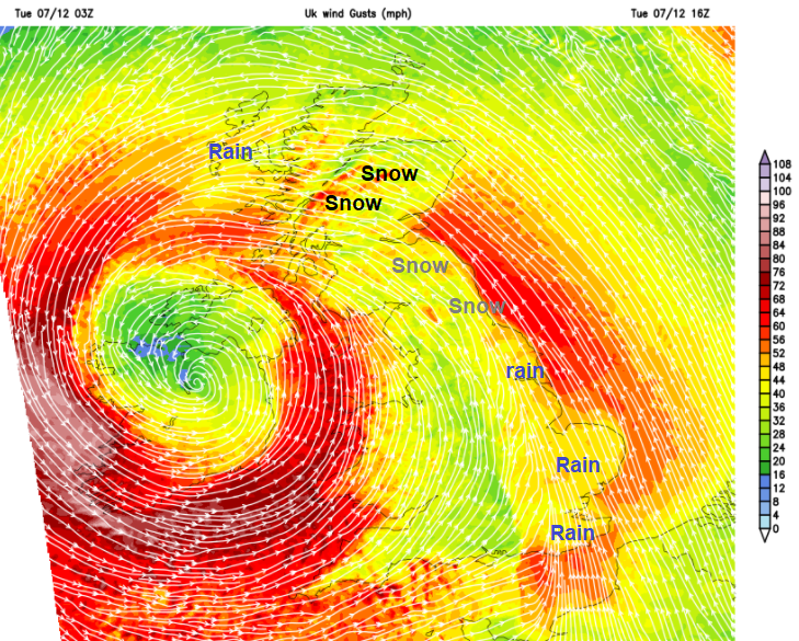
The low centre moves over the Isle of Man during the night with westerly gales battering western Ireland, Pembrokeshire and the whistling up the Bristol Channel
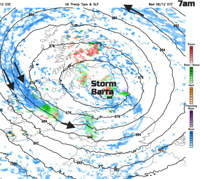
By Wednesday morning, the gales will still be pounding northern Mayo and Sligo, with wild seas and high gusts in the north-westerly winds. Around the low pressure there will be icy rain showers with further snow flurries for high ground. The worst of the stormy conditions do ease down for Wednesday but around the low there will still be strong, gusty winds for Wales, north Devon and northwest Ireland. Watch out for warning updates between 10 and 11am on 7th from the Met Office.
More chat about Storm Barra in the Netweather community forum
Loading recent activity...


.jpg?w=767)