After the wet, windy weather earlier in the month, quieter weather has taken hold. And although it will become cooler, the mostly benign conditions will be hanging around for a while yet.
We've already seen the two faces of autumn over England and Wales this month, with the very wet, windy weather of earlier in the week being replaced by warmer, quieter conditions. Whilst our taste of Indian summer will last into today across the East and South; a weakening cold front will be bringing somewhat cooler, fresher air from the West during Sunday. But it'll remain on the warm side for October and continue mainly dry as a weakening cold front fizzles out as it comes.
In complete contrast, it's a wet start to the weekend for the western half of Scotland and Northern Ireland. Still, the heavy rain that's brought flooding to some parts will clear today, with Northern Ireland, in particular, seeing some sunshine later. The East of Scotland is still dry, but here too, you'll see some rain today as a weakening cold front crosses the region, and as a result, the rain across these parts won't be quite so heavy. Top temperatures 13 to 15C in a mainly light to moderate South Westerly breeze.
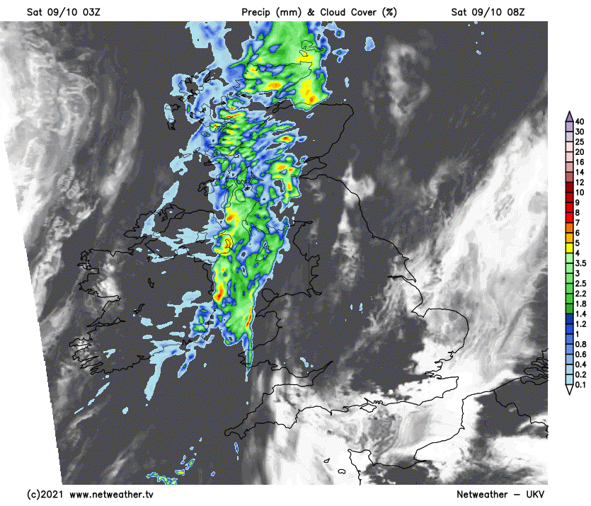
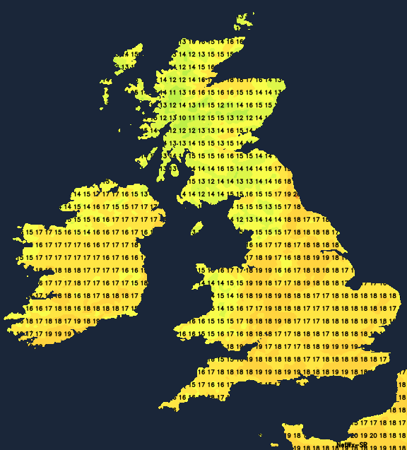
Cumbria, parts of northern England and the North and West of Wales may also see showers later, but it'll continue dry elsewhere. After a grey, misty start in places that'll lift into low cloud for a while in some parts, the sun will come through, especially across the East and South. However, over East Anglia and South East, we have some patchy fog to clear this morning that's dense in places before this too lifts and clears to leave a lovely day. It'll become warm again in the sunshine, with temperatures reaching 17 to 19C locally 20C in the sunnier spots across the South and South West.
The cold front brings some rain to northern England and the remainder of Wales after dark, but it'll weaken considerably as it moves into central parts later in the night. By the time it reaches here, it'll be nothing more than a band of cloud with patchy light or drizzle, while East Anglia and the South remain dry where mist and patchy fog could form again in light winds. Clearer skies over Scotland and Northern Ireland allow it to turn chilly in some sheltered glens, cold enough in fact for a touch of grass frost by dawn, as temperatures fall to between 2 and 6C in a mainly light Westerly breeze. Here too, mist and a few fog patches could also form, but across the remainder of the country, temperatures generally shouldn't fall below 6 to 10C.
By Sunday, our front across southern parts will just be a band cloud before clearing the South-East through the afternoon. This'll leave most places with a fine day giving sunny spells, although the North of Scotland sees cloud and a few showers moving in later. Here a West or North Westerly breeze will freshen a little in a somewhat cooler day for the East and South, with maximum temperatures 13 to 15C across the North and 15 to 17 or 18C further South.
The far North and North East of Scotland see a few showers after dark on Sunday, while most parts continue dry. There'll be clear spells, especially across Northern Ireland and central and southern regions where a West or North Westerly breeze will be light. It'll turn chilly and misty in places by dawn, with a touch of ground frost possible again in some of the more renowned rural 'hollows' as temperatures mostly fall to between 2 and 7C.
The North and East could see a few showers into the working week, but it'll be a mainly dry week with high pressure mostly in charge. Temperatures should be close to normal, with mist and patchy fog at night where skies remain clear.