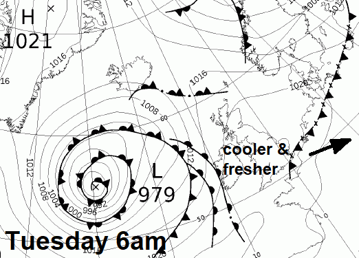
A weak cold front, bringing nothing more than cloudier skies, has cleared Kent and into the near continent this morning, ushering in slightly cooler and fresher air from the west across all parts for Tuesday. A brief ridge of high pressure builds in across the south today, ensuring most will have a dry and fine day, with temperatures reaching the low to mid-20s in the south. However, a cold front will move in from the west across Scotland and N. Ireland bringing a band of rain, ahead of a fairly deep low moving northeast towards the Faroes.
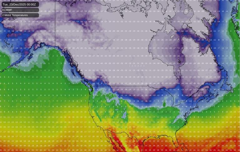
The cold front will stall and weaken across N England and Wales on Wednesday. Meanwhile, a long-wave upper level trough moving east over the Atlantic will amplify / extend south to merge with upper low near Iberia as it arrives and slows to the west of Ireland on Wednesday. This will serve to back the flow more southerly ahead of it across western Europe and allow a plume of warm and moist air characterised by high 850 hPa theta-w values (wet-bulb potential temperatures) of 18-20C to advect north-northeast across France on Wednesday, before moving across SE England & East Anglia Wednesday night and Thursday.
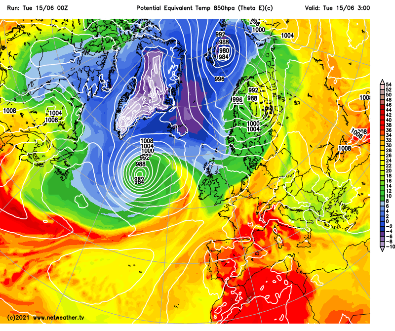
Theta-e (850 hPa potential equivalent temp) animation below shows upper trough (greens/blues) moving into the west amplifies south west of Iberia next 24-36 hours, which will serve to pull north unstable warm/moist plume towards SE England by late Wednesday,bringing thunderstorms.
Meanwhile, an Elevated Mixed Layer, composing of dry layers aloft originating over the higher terrain of the Spanish Plateau, will spread northeast over the Bay of Biscay and NW France crossing the warm moist high theta-w plume, which combined with cooling aloft from the west with the encroachment of the upper level trough, will create steep mid-level lapse rates and fairly large amounts of CAPE (Convective Available Potential Energy) over the Bay of Biscay, France and eventually SE England / E Anglia – as the plume and EML arrive here Wednesday night.
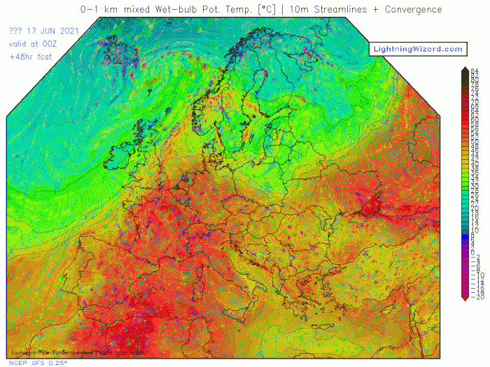
Theta-w (wet-bulb potential temperature) for 00z Thursday:
Elevated storms are likely to erupt up through the EML across the Bay of Biscay and NW France Wednesday afternoon and evening, as differential thermal advection of cooler air from the west overrunning the plume and increased ascent occurs from subtle impulses moving NNE in the strengthening mid-level flow.
The steep lapse rates of the EML will likely produce large amounts of MLCAPE, so storms will likely be strongly electrically active, so frequent cloud-to-ground lightning will be a hazard. Also, locally torrential downpours are possible from storms. Met Office in their thunderstorm warning mentions the potential for rainfall totals of 30mm in an hour, perhaps 50mm in 2-3 hours, this would lead to some localised flooding. Given the elevated nature of the storms, cold downdrafts associated with heavy rainfall will likely develop cold pools that will accelerate as they hit the surface and fan out – to create locally strong convective wind gusts, perhaps locally 40-50mph gusts.
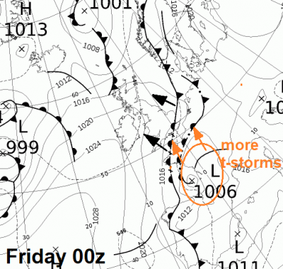
Wednesday night storms across SE England / E Midlands / East Anglia look to clear out into the North Sea Thursday morning, as a cold front moving in from the west tries to clear the plume away eastwards. But the cold front will stall close to or over SE England/EA and with the flow backing again ahead of a shortwave trough / thundery low moving north over France Thursday, the cold front will likely become a warm front lifting north and northwest and introducing an increasingly unstable warm/humid plume again across the southeast for Friday, with a risk of further thunderstorms pushing north across the English Channel from France during the day.
Friday's storms clear away out into the North Sea Friday night/early Saturday, with drier, cooler and fresher conditions pushing in from the west for Saturday, with a ridge of high pressure building in. But further Atlantic upper trough disruption over the weekend against upper level high over southern and eastern Europe will likely back the flow again and send another thundery low north across France towards southern UK, bringing a possible threat of thunderstorms later Saturday and into Sunday.
Looking at a timeline, for what looks like a stormy second half to the week across southern, central and eastern England, I have outlined days below of what may happen based on current model output:
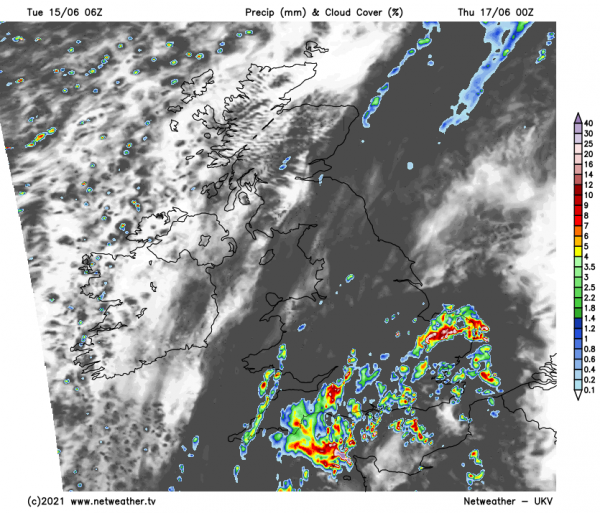
Elevated thunderstorms are modelled to develop over the Bay of Biscay and NW France Wednesday afternoon and evening before crossing the Channel and moving northeast across SE England, E Midlands, Lincs and East Anglia Wednesday late evening / night. Some uncertainty over the western extent, maybe parts of central S England and other parts of Midlands could see a storm too, but storm risk look mainly east of a line from the Isle of Wight to the Wash. The storms will likely organise into an MCS (mesoscale convective system), given airly strong mid-upper flow of jet increasing S/SWly jet (speed shear) and also veering winds with height from the surface (directional shear).
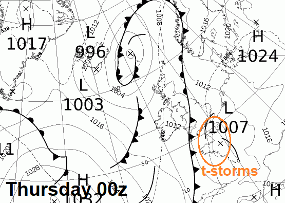
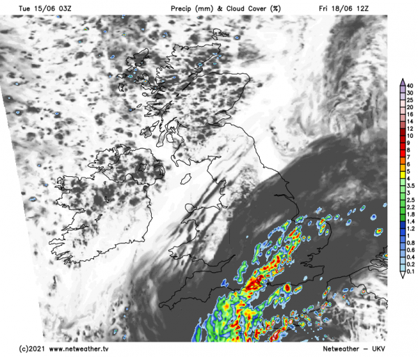
UKV model for 00z Thursday
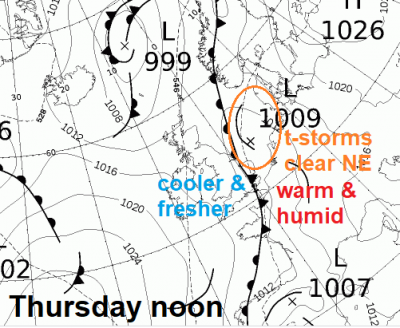
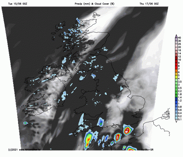
Netwx-SR model for 00z Thursday
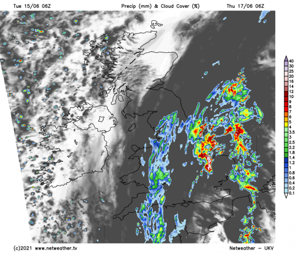
Storms pushing northeast across SE England and East Anglia look to clear out into the North Sea from East Anglia through Thursday morning, perhaps some low cloud with light rain or drizzle left in the legacy of these storms before weak cold front slowly pushes in from the west, perhaps bringing some brightness or sunshine but cooler and fresher conditions in the afternoon/evening.
Cold front lying N-S or NE-SW close to eastern parts of SE England / EA will try to push back northwest on Friday, with plume of warm and humid air returning here off the near continent, but with it a risk of further heavy rain and thunderstorms pushing north over the Channel out of northern France. Again, some uncertainty over the timing and westward extent of the heavy rain and storms moving N and NE from models. 00z ECMWF and ARPEGE further east with just SE and E Anglia, GFS and ICON further west to include central S England and parts of the Midlands too. These storms clearing into the North Sea Friday night.
Loading recent activity...