Several more days of sunny spells and hefty showers, even thunderstorms for some. Later this week an Atlantic low looks to bring a spell of very windy weather across the UK.
Another week of cool showery weather. Some places seeing lots of downpours, some heavy with thunder. Other areas missing most of the showers and receiving strong sunshine, but that uncertainty of rain lingers. The main change of the week will be a large Atlantic low striding in for Thursday/Friday. Instead, that will just bring wet and windy weather right across the UK.
May 2021 has been colder than average and wetter. That doesn’t look to change much. Even by next weekend, the low pressure looks to still be with us. It would be nice to have some real spring warmth, to sit out in during the evenings.
The advice for flood waters remains - Turn around, don't drown.
I was asked “why does my weather app say it will rain all day on Saturday?” The app was just the default weather from Apple in the US, so I suggested having a look at the 7-day weather forecast for comparison. The app was just showing the likelihood of showers in a large grid square. There were plenty of showers about at the weekend, but this location did stay dry. And in the current showery situation, it is not likely to rain all day. The showers come and go. All-day rain comes from frontal rain getting stuck. As happened to Devon last Thursday. The radar shows the bigger picture.
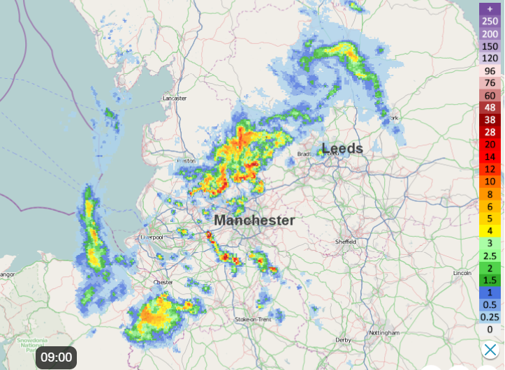
There can be areas with clusters of showers, such as over northern England this morning. Here conditions are poor on the roads, a wet start to the day. But a few miles north or south it is dry. The focus today for the heaviest showers with the risk of thunderstorms will be for southern and eastern England. Northern Ireland will see a few showers today but a lot of fair, bright weather. Temperatures of 13 to 15C and a very light westerly wind. Western Britain becomes dry and fine with sunny spells. There are showers to start the day over Flintshire and Conwy, but these fade and Wales should have a fine day. Temperatures at only 12C on Irish Sea coasts but 15 or 16C inland with a westerly breeze. The rest of Britain will be in the mid-teens with a light westerly flow. A fresh breeze through the English Channel today. The sunnier spots will feel warm today but, in the shade, and showers and certainly as the sun sets there is still an edge to the air.
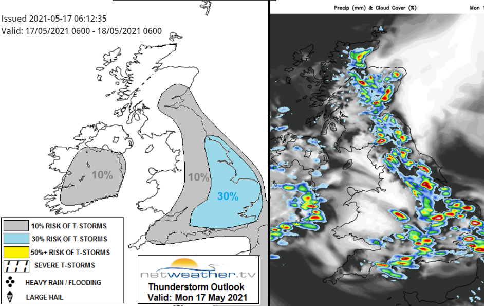
The convective forecast shows the areas most at risk of thunderstorms with hail today. The showers gradually fade with just a few lingering this evening for Northern Ireland but mostly over eastern Britain. The winds will be very light tonight with clear spells and temperatures dipping into single figures.
A frontal band drifts down from the north bringing murky, damp conditions to the Northern Isles overnight. This light rain and drizzle will spread into the far north of Scotland during Tuesday accompanied by a north wind. For the rest of the UK, it will be another day of bright or sunny spells with showers. Again, the risk of hail and thunder, but more scattered. SW Britain could see pulses of heavier showers during Tuesday
The showers over southern Britain should be clearing SE England by Wednesday morning as the frontal band in the far north will have reached central Scotland. So damp and grey here. Another day of hit and miss showers midweek.
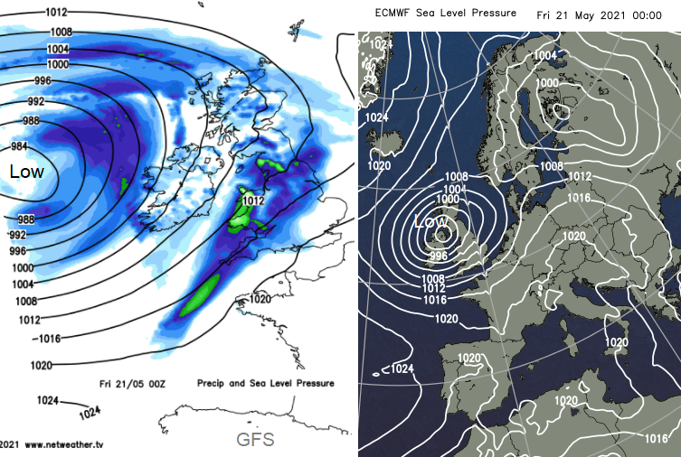
Then for the end of the week, an Atlantic low. There is still uncertainty about the speed of the incoming low, how deep it will be as the models don’t quite agree. However, there is a strong signal for a spell of very windy weather with gales, even severe coastal gales. Accompanied by rainbands swirling around the low into the weekend.