With the jet stream close to the south and low pressure nearby over the next 7 days, expect showers or longer spells of rain over many areas, staying cool too, with temperatures below average. But hints of something drier and more settled arriving next weekend.
May has been rather cool so far across the UK, mean temperatures around 2C below the long-term average, while it’s been wet for Wales, SW England and parts of northern England. Wales seeing at least 25% more rain than would be expected for the whole month – according to the Met Office in their latest blog.
For the next 7 days, it looks like there will be little change in our weather, so it will remain cool and showery by day, with some longer spells of rain at times -particularly in the south. The culprit is the jet stream, which is strong across the Atlantic but running east just to the south of the UK and in across France and on into central Europe. This means the British Isles will be on the cold side of the jet stream this weekend and through much of next week too, so temperatures will generally stay slightly below average.
Jet stream forecast for the next 7 days shows the UK on the cold northern side of the jet, with areas of low pressure crossing the UK bringing showery conditions:
Temperatures remaining below average across the UK and much of northern Europe over the next 7 days
A strong jet stream blasting east across the Atlantic and just to the south of the UK into France this weekend and through next week will bring a succession of low pressure systems and showery troughs on its northern flanks east across Britain over the coming days. One low will move east across southern England on Sunday, a frontal system moving east ahead of the low will bring a spell of rain across England and Wales Saturday morning, followed by sunshine and heavy showers in the afternoon. Sunday seeing widespread heavy showers and thunderstorms develop as that low moves east across the south – more particularly across England, Wales and Ireland.
A similar story as we head through next week, staying north of the jet stream in a cool and showery polar maritime airmass throughout, so temperatures generally remaining a few degrees below average, highs reaching the mid-teens at best. Cold air aloft, but the ground warming in the strong sunshine will create instability – allowing clouds to rapidly build upwards, deep enough for heavy showers with hail and thunder.
Showers for many each of the next 7 days.
Credit: wxcharts.com
An unstable westerly flow Monday and Tuesday, meaning further heavy showers and thunderstorms will break out during the day, particularly for England and Wales. Another low crossing the south on Tuesday, perhaps merging the showers into longer spells of rain. Low pressure over the Norwegian Sea mid-week looks like swinging south towards Scotland then southeast into the North Sea on Wednesday, meaning heaviest showers could be in the north, while the low to the northeast pulls in a chilly northerly flow across the north, perhaps turning the showers wintry over higher ground here for a time. Potentially another low moving off the Atlantic this time and moving east across the south for Thursday, bringing a spell of rain, showers breaking out to the north, but some uncertainty over the track this far out, weather models differing in track. More showers on Friday, winds perhaps turning more northwesterly, so a chilly feel to end the week.
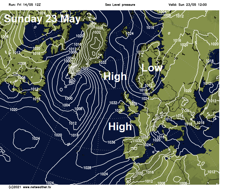
However, recent weather model runs, and their ensembles have indicated the tendency for pressure to rise the following weekend (22/23 May) – as an area of high pressure build close to the west. Signifying a change to drier and more settled weather, perhaps developing into the last 3rd of the month. But don’t get out the shorts, beachwear and flip-flops just yet, as, with high pressure to the west and low pressure to the east, the flow will likely be from the north, bringing down chilly air from the arctic and perhaps the return of frosts in the north.
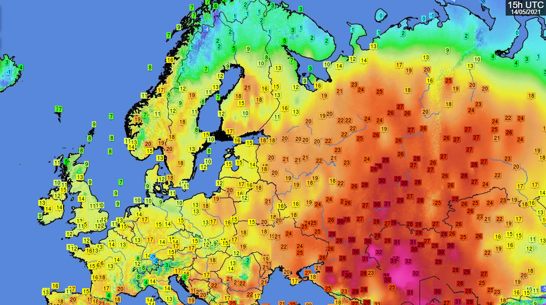
But if you are wondering where all the heat has gone, look to the east and northeast over western Russia - where highs have reached the mid-20s celsius today close to the arctic circle, with 20C across parts of southern Scandinavia.