Plenty of movement with our UK weather, showers whistling by, sunshine appearing and blustery winds. A dramatic shift to colder air on Friday with snow showers for northern hills.
By next week the restrictions in England will have eased and the weather looks warmer, particularly for eastern areas in the first part of the week. Easter weekend looks colder on the charts at the moment. Before this easing, we have a chilly dip across the UK on Friday and some very windy weather at the weekend.
The weather is very mobile, with low pressures whistling across the north Atlantic. Most are centred closer to Iceland, but their weather fronts and blustery winds are affecting the UK. Last week, high pressure was bringing steady, settled conditions but this week is much more changeable with rain or showers from the west and sunshine in between.
There is a cluster of small low pressures away to the north today bringing a south-westerly flow to the UK, fresh around NW coasts and hills but starting off very light for Kent and London. For much of England and Wales, there is a fine, bright start. Many places start off dry but there are a few showers for West Yorkshire and a large cluster over SW Britain. This wet weather for SW England and SE Wales is forecast to spread eastwards today, across to East Anglia and the Home Counties. So, there will be more cloud about and the risk of rain but gaps in between. Further north from this, away from Cumbria but up into eastern Scotland there is more fair, bright weather with sunny spells and with some shelter temperatures rise to around 13 to 15C.
Further north and west there are already plenty of showers and more will follow. For Northern Ireland, the far north of England and Scotland, mostly the west coast but also reaching inland. Any of these showers could bring quite a change in the day, darker clouds, feeling cooler and sudden rain but it will then move on.
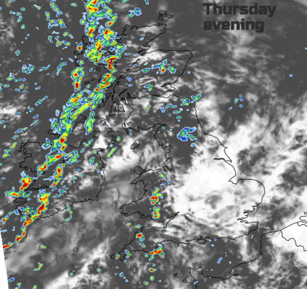
Overnight and early Friday a more distinct cold front will move through bringing a spell of wet and blustery weather and then introducing colder air. Later this evening heavier bands of showers appear from the west and a slight wave on the front reaches western Scotland tonight with snow on the mountain tops.
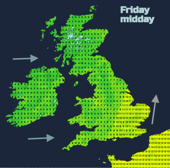
The main cold front will be over Northern Ireland before dawn, with a spell of heavier rain, a distinct veer in the wind to a westerly and then a much colder feel for Friday morning. After 12C today, Northern Ireland will reach only 7C on Friday. The cold front then makes its away across Britain during the day with a spell of heavier rain, blustery winds and a change to the colder air. SE England and East Anglia will see temperatures rise into double figures 11 to 14C in brisk S to SW winds but other parts of England will feel temperatures drop and for most of the UK it will be a colder afternoon.
The frontal band will reach SE Britain later in the afternoon with bright skies behind, but showers continue to feed into the far northwest and will begin to turn wintry.
It will be a colder night with a chilly wind from the west. There could be ice along with sleety, icy showers and snow over the hills of Wales, Northern Ireland and northern Britain.
During Saturday morning the showers become subdued, but it will be a chilly start, even with sunshine and the risk of ice in places and some slushy deposits with a few cms of snow lying for northern hills and mountains where the showers have passed by.
There will be a lull for a time on Saturday with sunshine and drier conditions, the winds easing down but another low pressure is heading in for the rest of the weekend. Southerly winds pick up for Ireland with more cloud and outbreaks of rain in the afternoon. Overnight another band of heavier rain and mountain snow moves over Scotland, into Wales and northern England by Sunday morning. This band will wave over Britain on Sunday with more unsettled weather and brisk winds and the windy conditions with rain from the west lasts into Monday although it will feel milder in the south.