Snow continues over northern Scotland with recent rain still bringing flooding concerns across the UK. Next up, passing Storm Justine which should throw even more rain our way and maybe some snow.
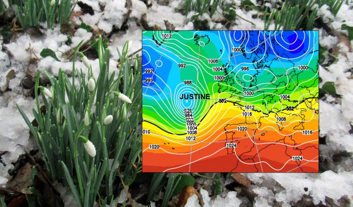
This weekend the UK is on the northern side of Storm Justine (also affecting France and northern Spain). This low looks to bring heavy rain to SW Britain and adds the risk of snow, with a good deal of uncertainty. Before that, more rain, lots of warnings and a continuing eye on the flood situation.
Snow and rain have featured heavily in the forecast for January. The snow, perhaps not heavily enough for those wanting to sledge or build snowmen. And too much rain resulting in the recent flooding. It has been a tricky time as frontal bands have butted up against cold air and changes in reach of the rain have led to warnings not quite hitting the mark.
The Environment Agencies have been busy along with local authorities in testing times putting flood defences in place and for towns such as Didsbury and Bangor-on-Dee assisting evacuations. Not easy late at night, in the dark with ice and the ongoing COVID restrictions.
It's a funny time for weather warnings which have long looked at busy times of the day, transport networks and are a lot of people out and about? That feed into the Impacts pot. Met Office warnings area impact based so not just 50mm rain equals a Yellow warning, 75mm of rain gets an Amber. So, land gales on a Monday morning over Greater London would have more impact (in normal times) than say Inverness on a Wednesday night.
The rain warnings consider the existing ground conditions and river levels in discussion with the Environment Agencies which is why the weather and five-day flood outlook should look similar.
The snow warnings are harder to pin down. It’s January, mid-winter. Do we need a warning that it might snow? Probably yes. There should be fewer people moving about and travelling by train or car but there are still key workers and others who can’t work from home, a smaller number of children getting to school. And there is now the hugely important need to keep people for going to hospital. Slips on ice and snow, particularly by the elderly contribute to a huge number of emergency hospital admissions each year. So, the yellow warnings for Snow which appear a few days ahead might enable people to make a choice to get their shopping on a different day, even if in the end the snow is less widespread. The Saturday Met Office snow warning is marked as 'Unlikely' currently, that there will be 'Medium' impacts.
These snow warnings aren’t reflecting a Beast from the East setup of 2018. This is mostly Atlantic systems continuing to run in from the west or SW and it’s a delicate balance of where and if the cold air ahead can tip the frontal rain into heavy snow. Usually, this happens over the hills but as Wales and southern England saw last weekend and southern Scotland the week before, it can occur to low levels. The following mild air can result in just rain through. Just because you have a yellow warning, don't expect decent snow. Treat it as a heads up for a few days before.
Current snowfall
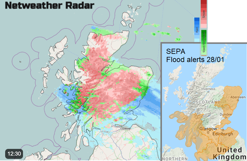
Snowfall for Scotland continues north of the Central Belt tonight and into Friday. The precipitation band nudges a bit further north through Highland. During Friday morning it is easing away eastwards so more for Grampian perhaps even turning wintry for Aberdeen by Friday lunchtime.
“Heavy snowfall may bring significant disruption to travel across parts of central and northern Scotland. Above 200 m elevation significant and prolonged snowfall is possible throughout Thursday and Thursday night before easing during Friday morning” MO
Current rainfall
Along the North Sea coast of NE Scotland, there is a rain warning linked to this same band and also Flood warnings from SEPA the Scottish Environment Agency over southern Scotland.
“Persistent rain on Thursday and into Friday morning, in combination with some snowmelt from lower levels, could cause flooding impacts from surface water and rivers in low-lying coastal areas”.
For NW England throughout Thursday, around Cheshire, Merseyside and Greater Manchester, there is also a rain warning. Not for great totals but the situation is already sensitive.
“Falling onto already saturated ground, this rain, in addition to that which has already fallen today, may cause some further localised flooding.” MO
Into the weekend
The lower reaches of the River Severn could see ongoing local flooding throughout the weekend due to rain that has already fallen. The larger rivers have dropped but are still bank full and sensitive to any more rain. Southern England looks windy on Friday then the weekend does turn colder for areas that have been mild this week and there will be frost and ice.
“Local flooding is probable in parts of south-west England on Friday and into Saturday. “EA
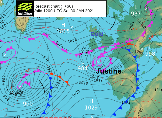
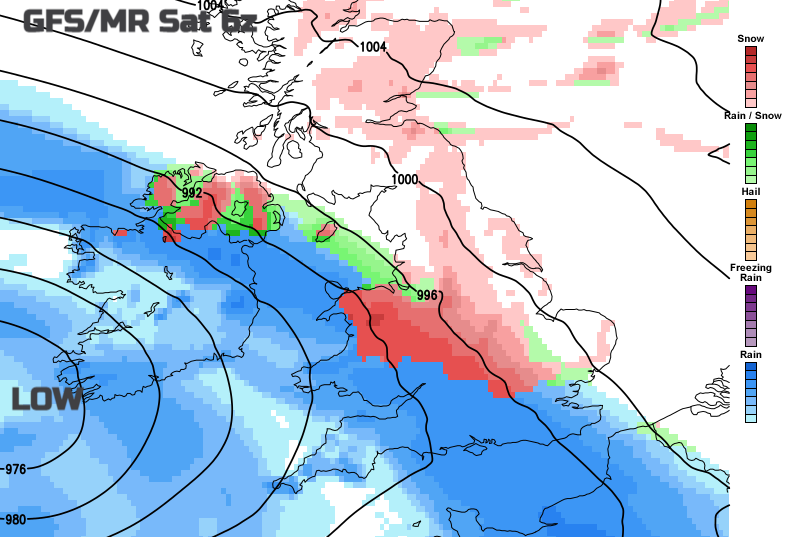
The heavy rain and possible snow for Friday night into Saturday are down to an incoming low pressure which rears up near SW Ireland and then should end up in the Bay of Biscay. There are winds warnings at the weekend for SW France and northern Spain from Storm/Tempête/Depressão/ Borrasca "Justine” named by Portuguese, IPMA in the SW Europe group. The cold front well ahead of the low centre will bring wet and windy weather over Iberia and France on Saturday with avalanche warnings and a snow warning on Saturday at 30% risk for a few cms of snow in the far north of France, just across from Kent.
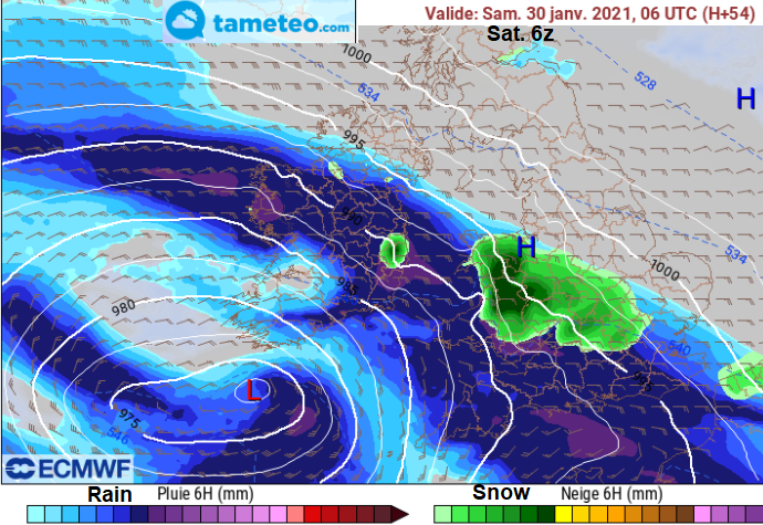
Linked to that, we have a band of frontal rain arriving later Friday and by Saturday morning there looks to be snow on the leading edge. The air ahead isn’t really cold, but the Welsh mountains could see heavy snow for a time. It looks increasingly windy on Saturday with a cold easterly wind.
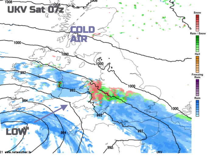
Looking at the various models there are differences in northerly extent, the rain over Northern Ireland in particular and up to the area of NW England covered by the rain warning today. The significant snow might reach over more of the Midlands, even the Peaks. Hills as always look more likely. Or it could be just a wet mush, there are lots of factors in the balance and Storm Justine hasn’t undergone its rapid deepening yet out in the Atlantic, that is for early Friday.
Even after that, there are further bands of rain, blustery winds and the risk of snow into next week for the start of February. There are also Spring Tides this weekend, so that will also contribute to the flood risk with all this water running through the river systems, the melting snow and already saturated ground.
More discussion about the models or regional outlooks around the UK and in Europe in the Netweather forum.