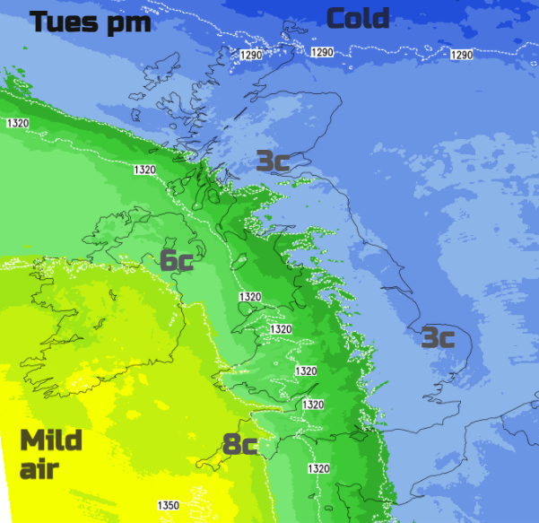
Cold air holds on in the north as mild air follows numerous bands of rain. The result - snowfall on the leading edge, mostly on the hills and more rain increasing the flood risk. Add melting snow in there too.
As winter continues, there is more rain on the way. Flood warnings have continued from Storm Christoph torrents last week and in between, there has been snow. Further snow is forecast today but mainly for the hills of northern England, central and southern Scotland as a frontal band moves in against the cold air. As far south as the Peak District and Staffordshire hills could also see a bit of snow.
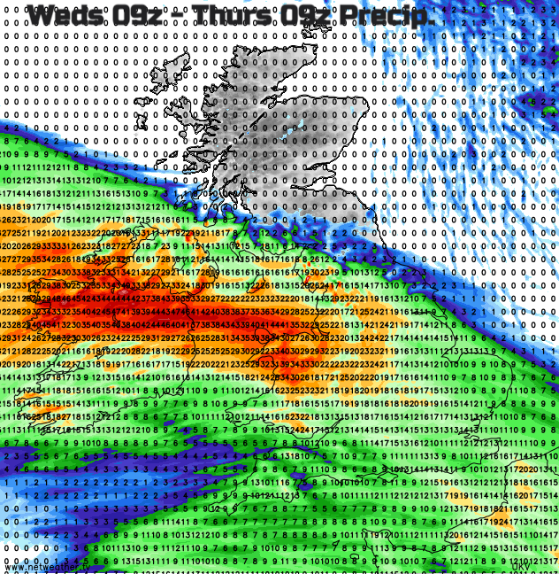
Later in the week more active rain bands head in off the Atlantic, resulting in heavy rain particularly for Wales, NW England and West Midlands, Northern Ireland and at times reaching the far south of Scotland. All areas which have seen plenty of wet weather recently and flooding but also have snow to melt. Once more there is a distinct temperature gradient and a warning for snow through Thursday and overnight into early Friday.
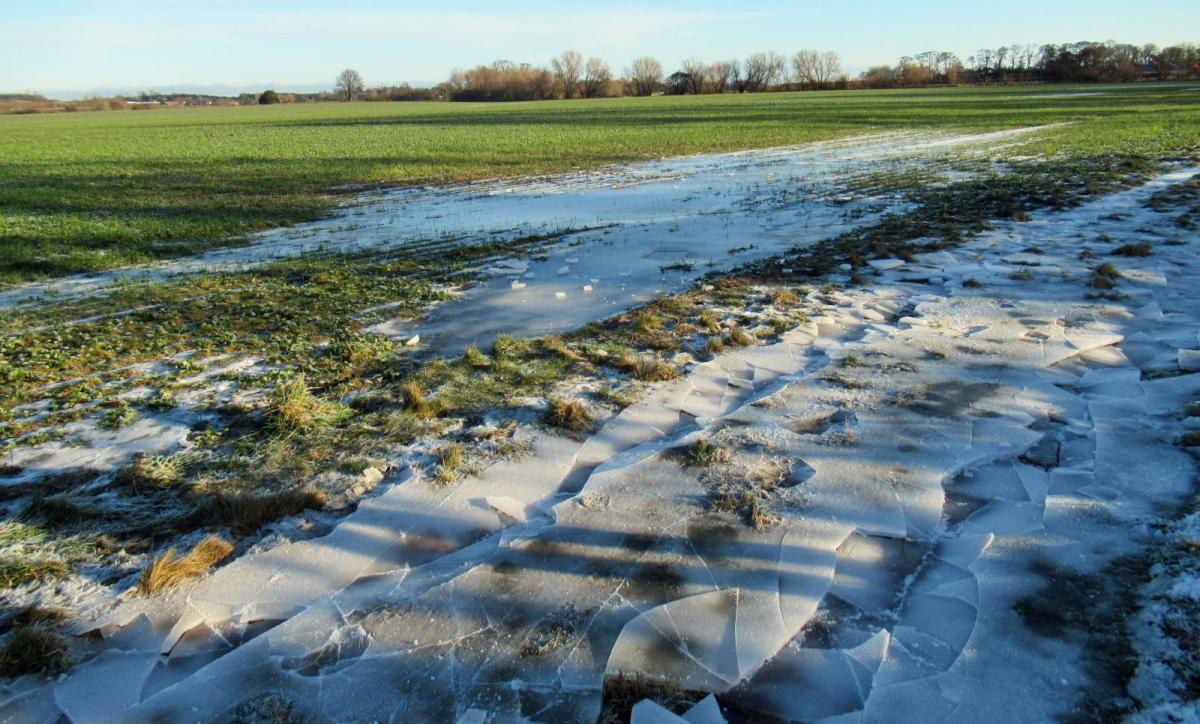
So different types of severe weather this week; heavy rain, snowfall, lingering ice and the impacts of further flooding, travel disruption even in these restricted times when traffic should be less.
There will be some uncertainty, as always with snowfall but also with where the frontal bands settle. If slightly further north or south or if the orientation is different other parts could see heavier rainfall and so heightened flood risk. Also, just because your location is not under a yellow warning it doesn’t mean that you won’t see heavy rain or snow, just that the impacts have been deemed lower than the warning criteria.
Also, just because you are under a yellow warning for snow doesn’t mean that you will get a covering you are just in a more likely forecast area. It is frontal rain with mostly hill snow, so these are widespread events, not hit and miss showers.
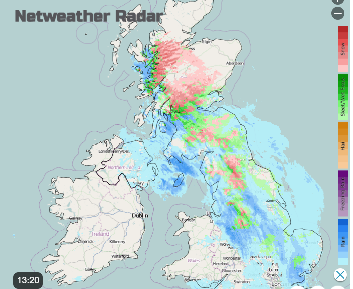
The Tuesday snow warning lasts into the night. An approaching warm front and occlusion continue to move in from the Atlantic today with the triple point (and usually the heaviest precipitation) diving across from western Scotland to The Forth. For England, there will be rain with wet snow for a time this afternoon but over the hills there could be up to a couple of cms with a bit more for the higher Pennine routes and through the Southern Uplands.
“Hill snow may lead to some travel disruption, the most prolonged hill snow coming north of the Central Belt in Scotland.” MO
It looks like just north of the Central Belt will see the most snow today with a light easterly breeze which falls calm. 3 to 15cm of snow over the hills through central Scotland, The Trossachs, around the Great Glenn up to the Grampians but not the far north.
The impacts from this have been deemed Low by the Met Office on their matrix used to decide warning colour- yellow but there is still lingering snow and ice from last week and a cold night to come. As the frontal rain and snow begins to fade over Scotland this evening, another little feature is showing up on the UKV model, so extra forcing bringing another burst of snow and rain across the Central Belt to SE Scotland, might be worth watching on the radar.
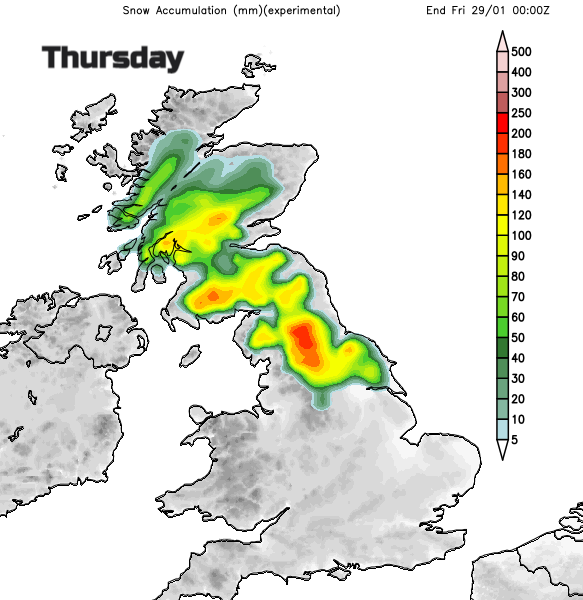
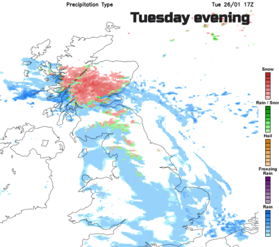
Thursday – This is a bit further ahead and so the forecast may shift the frontal bands a bit. Worth keeping an eye on the overall picture, not just hourly app symbols. Again, there is cold air to the north and even milder air to the south. Frontal rain heading in from the Atlantic and snow again. This time there could be heavier snowfall.
“Heavy snowfall may occur across the hills in this region and bring significant disruption to travel.” MO
Later on, Wednesday new frontal bands head up from the SW across the UK. They are forecast to hit the early morning cold air over northern England and southern & central Scotland. Once band slows down over Scotland and another band catches it up ready for the cold start on Friday. Again, it looks like the main risk is for northern hills but there could be snow to lower levels with a few cms. For the higher routes there could be tens of cms of snow and on Thursday a brisk easterly wind leading to difficult conditions higher up and a significant windchill.
Sunday could bring another spell of wet and wintry weather with strong winds showing at this stage.
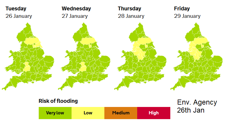
There are still numerous flood warnings and alerts in place over England. On the River Severn, taking its time to react to last week’s rain and Derwent, the River Dee after the town flooding and Severe flood warnings. And the River Ouse, again after Christoph’s rain.
NW England has already been highlighted as seeing impacts from the rainfall this week, there is a yellow warning for rain for Thursday. Wales has dropped its alerts and warnings so is a better starting point before the next influx. However, there will be plenty of wet weather from the west.
“Local flooding from rivers and surface water is probable in NW England on Thursday and Friday and is also possible in parts of Wales and northern, central and eastern England.” EA
Northern Ireland, Wales (particularly the north) NW England into the Midlands (particularly the Peaks) all look wet with the heavier rain reaching into SW Scotland and over more of the Pennines, into eastern England during Thursday. There are already groundwater issues in North Yorkshire. Also, there will be snowmelt adding to all this.

It’s quite a mix this week, a balance of mild air in the south with rain yet cold air to the north that manages to hold on, keeping the risk of snow and also ice.