Cold and frosty for many to start Christmas Day, but weather going downhill Boxing Day as Storm Bella brings gales and heavy rain. Turning colder again from Sunday, with some wintry showers.
Yesterday was dull, wet and mild day across central and southern areas, with parts of Wales, the Midlands and East Anglia still affected by flooding issues today after prolonged and heavy rainfall yesterday falling on already saturated ground and flowing into already swollen rivers. There are 112 Flood Warnings across England and 5 Flood Warnings in east Wales.
However, quite a change for all parts today, with a cold northerly wind across all parts and it’s dry for most away from eastern coastal areas – where there are some wintry showers bringing a mixture of sleet and snow. Earlier today there were plenty of pictures on Twitter of snow settling in eastern Scotland and NE England. Christmas Day is looking mostly dry and chilly, but turning cloudier from the northwest for many. Some rather stormy weather is waiting in the wings for Boxing Day though, as #StormBella sweeps in from the northwest, with amber and yellow warnings out for wind and rain across England and Wales.
Back to today, the rest of the afternoon will stay dry and bright for most, best of the sunshine across central and western areas away from eastern and western coastal areas – where there will be more in the way of cloud and some wintry showers feeding down across coastal counties of Scotland and eastern England, falling as sleet and snow. Highs this afternoon reaching 2-4C at best in the north, colder over higher ground, 4-6C in the south. With the wind chill of the strong northerly wind, feeling more like below freezing in the north and around freezing in the south.

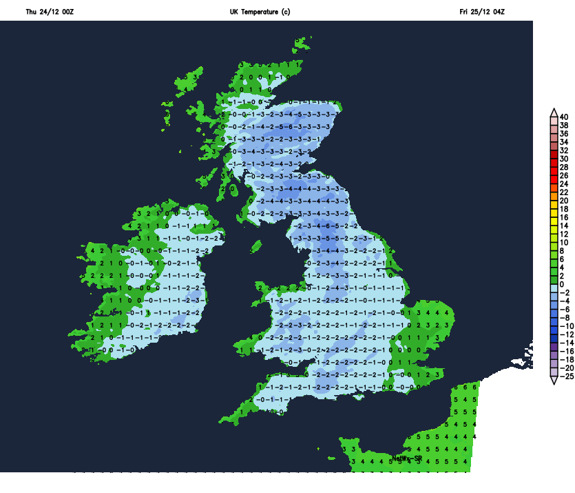
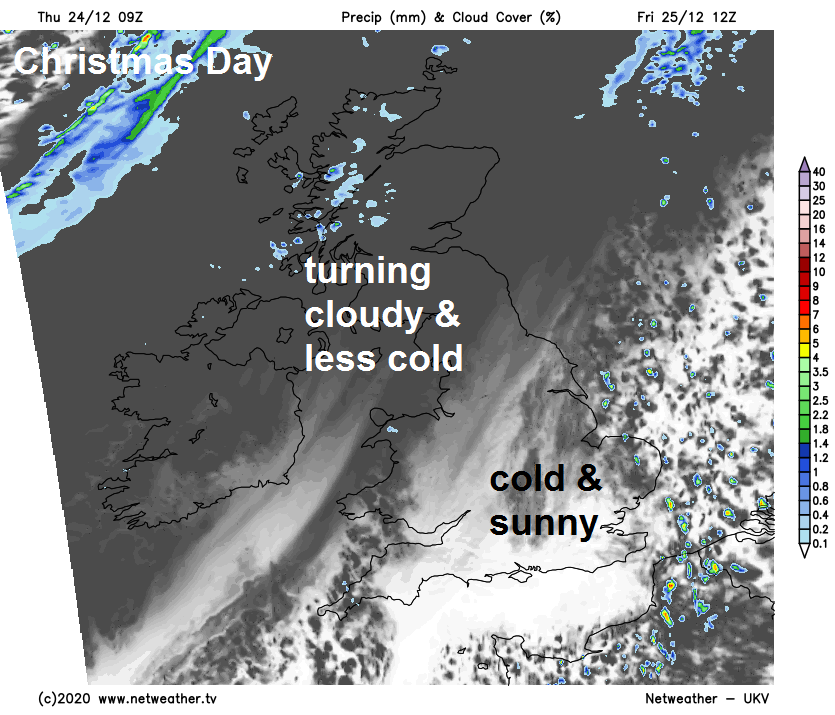
Clearing skies and winds easing for most tonight, as high pressure builds and with cold arctic airmass temperatures will quickly fall below freezing away from eastern coastal areas – where the stronger wind will continue. So a widespread frost tonight, temperatures falling as low as -6C across northern England, with many waking up to a crisp and rather cold start on Christmas Day. Though it will have turned cloudy and less cold across the northwest overnight.
A dry, bright or sunny and crisp morning across much of England and Wales, however cloudier skies arriving across the northwest overnight will spread across Scotland and N. Ireland in the morning, before spreading southeast across Wales, northern and western parts of England through the afternoon. Outbreaks of rain pushing in across western Scotland, drizzle over western hills and generally turning breezier in the west. SE England and East Anglia likely stay sunny until dusk. Turning less cold across the west, with afternoon highs of 6-9C, colder in the east, with highs of 4-5C.
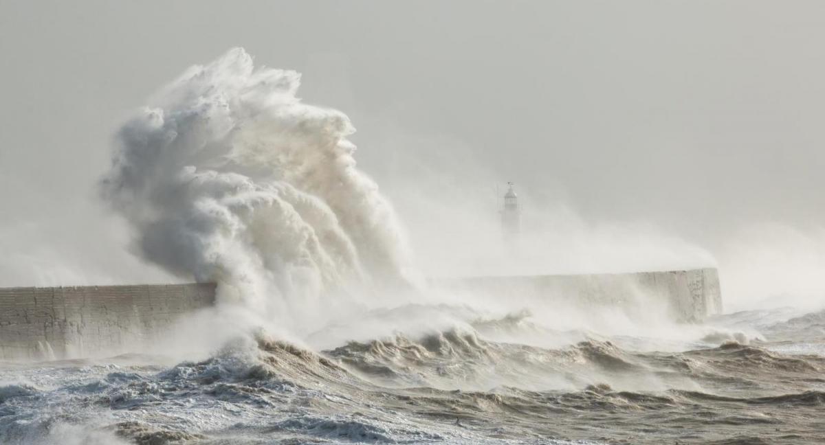
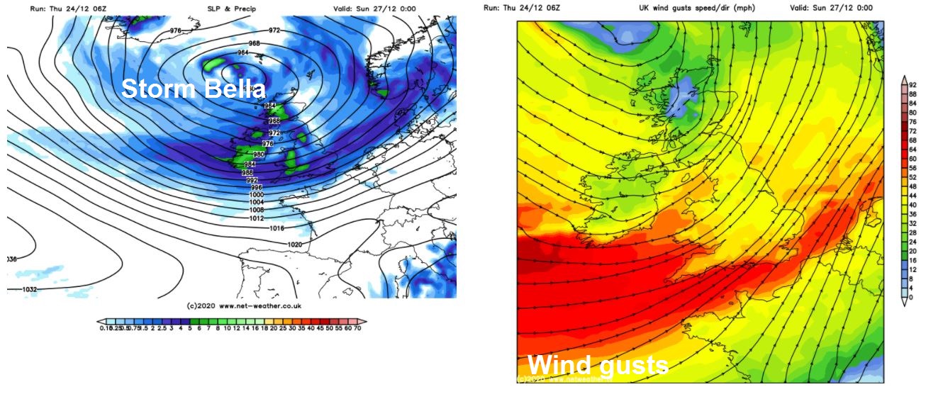
All change again on Boxing Day and unfortunately not a pleasant change in weather. A deep and powerful Atlantic depression, named Storm Bella by the Met Office, drops down from Iceland towards northern Scotland during the day, tightening isobars, the strongest winds across England and Wales. Wind gusts in a Yellow Wind Warning covering much of England and Wales reaching 50-60 mph generally, perhaps up to 70mph over exposed coasts and hills. But across southern coastal areas of England and Wales an Amber Warning has been issued for gusts reaching 70-80mph. There are also Yellow Warnings for rain for NW Scotland, NW England, Wales and parts of western England for the additional rainfall falling on already saturated ground and into already high rivers.
As well as the gales developing across many parts through the afternoon and evening, rain will spread into northern and western areas through the day, locally heavy, particularly over hills, while turning to snow over Scottish mountains as colder air filters in from the north. The rain perhaps not reaching SE England and East Anglia until later afternoon or early evening. The rain turning widely heavy and squally as it reaches southern areas, which combined with the strongest of the winds developing here into the evening and overnight will make for particularly unpleasant conditions during the evening and night – with difficult driving conditions on the roads after dark.
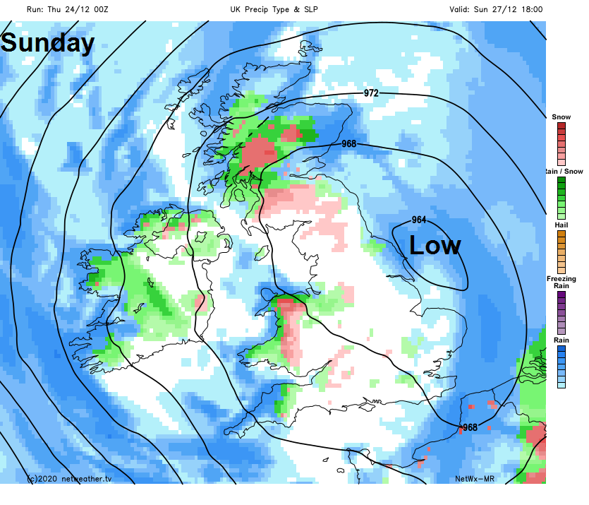
Weather calming down somewhat on Sunday but turning much colder again. Early heavy rain clearing southern parts then winds easing with skies turning brighter or sunnier, but there will be showers moving in from the west, which will be wintry in nature, with snow falling over hills but also to lower levels in the north and west. Most of the showers will be across western areas, eastern parts drier and sunnier.
Next week remaining on the cold side but unsettled with low pressure over or close to the UK, this will mean a risk of wintry showers and also longer spells of rain, sleet or snow a times, while frost is likely anywhere where skies clear at night.