'Cloudy with outbreaks of rain' - not a phrase that is ever likely to get the pulse racing. But that could just about cover most of the next few days, as Atlantic systems continue to make slow but steady inroads across the UK, bringing changeable, milder, and increasingly wet weather.
'Cloudy with outbreaks of rain' - not a phrase that is ever likely to get the pulse racing. But that could just about cover most of the next few days, as Atlantic systems continue to make slow but steady inroads across the UK, bringing changeable, milder, and increasingly wet weather.
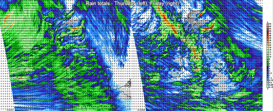
Talking of rain, while many parts will generally only see patchy rain during the next 24-48 hours, it will tend to stick over the east of Scotland, with rainfall totals of 50mm or more in places during the next couple of days. That's liable to lead to some issues with flooding, which is why the Met Office has issued a weather warning.
For the most part though, daylight hours today (Thursday) won't bring a great deal of rain, some patches of mostly light, drizzly stuff drifting in from the west. There'll be a lot of cloud around, so if you catch some brighter, sunnier spells you'll be doing pretty well. Temperatures will typically range from 4-7c, but milder air will be edging in from the southwest with highs rising into double figures here.
This evening and overnight, a more spritely band of rain will move in from the West, having crossed Ireland during the afternoon today. This one will have some heavier bursts of rain on it, although it will become patchier as it moves east. It'll also tend to arc back and stick around over parts of Eastern Scotland through tomorrow, allowing those rain totals to climb. Timings wise, it'll cross much of the country overnight to be sat over eastern Britain first thing, it should clear most eastern parts of England soon enough though. It'll be a windy day in the east and particularly the northeast.
Following the rain, there'll still be a lot of cloud, along with a scattering of sharp showers, which will be most frequent in western regions. They're likely to organise themselves into a band and push east later Friday and into the start of the weekend. But it will be a struggle again, with the rain again turning more patchy further east.
Saturday will be another of those 'outbreaks of rain' days, but some clearer air with sunnier skies will try to move in from the west during the day. How much progress it'll manage to make before the sun goes down is uncertain though. With those clearer skies, there could be a touch of frost in places overnight, but a band of sometimes heavy rain will be on the way in from the southwest, which is going to mean a spell of rain is likely for most on Sunday.
It'll be blustery too, with quite a range of temperatures across the country. The south and west will be mildest with highs perhaps touching into the teens, head north though and a chillier 4-7c is more likely.