Storm Barbara is bringing rain and some strong winds to southern and central England today. Tomorrow will be quieter though, thanks to a brief ridge of high pressure.
Mid-October can sometimes produce noteworthy storms, and while the remnants of storm Barbara won't come into that category, it's giving a wet start to many places South East of a line from Hull to Cardiff. But we have to keep an eye on this storm as it tracks north, as it could give gusty winds to gale force for a short time across Kent and along the south coast, east of the Isle of Wight.
Much of the rain is light at the moment, but there'll be heavier bursts before the rain fragments into showers later. Parts of East Anglia and the South East could even see a few sunny intervals this afternoon, while some central parts remain dull and wet. We also have an area of wet weather across the North and West of Scotland at the moment, but this too should fragment into showers. Elsewhere there are narrow bands of rain between areas of broken skies and scattered showers giving a few sunny intervals that'll persist throughout the day.
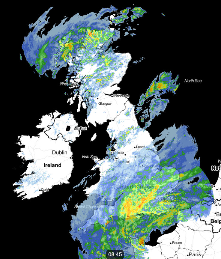 Check the latest rain radar here.
Winds generally will be fairly light, but a North West or northerly wind will feel chilly across Northern Ireland and the far North West keeping temperatures here to between 10 and 13C. Across the bulk of the country though, 14 or 15C is more likely with 16 or 17C possible again across parts of East Anglia and the South East where you see a few sunny intervals later.
There'll be further rain into the evening East of the Pennines, with showers continuing over the North and East of Scotland and across Northern Ireland for a while. Overnight however the weather should slowly improve, but there'll continue to be scattered showers. Towards morning Northern Ireland and mostly western parts of England and Wales should see skies breaking to perhaps give a few clear intervals. It'll feel chillier however in a West or North Westerly breeze, although temperatures, on the whole, shouldn't fall below 7 to 11C.
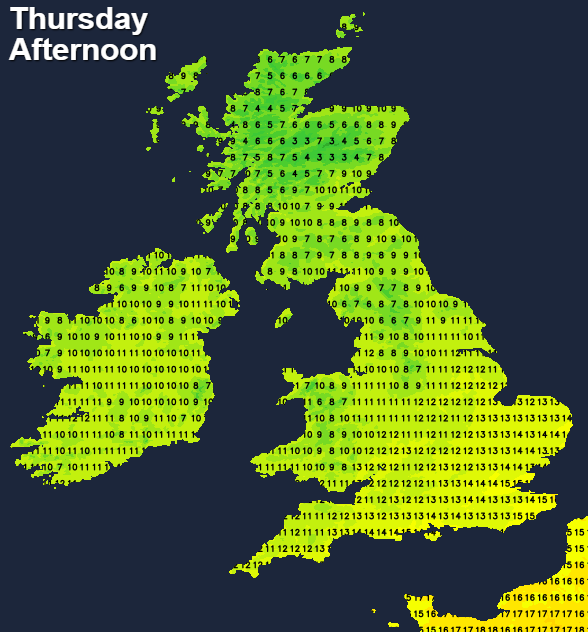
Thursday should be drier and brighter, as a transient ridge crosses the country from the West. There'll be sunny spells, but it won't be entirely settled with a few showers dotted about and probably some residual rain to clear from the East and North East of Scotland at first. A light or moderate North West breeze will become South Westerly on a better day that should be dry for most. But it won't be as mild, with top temperatures 9 to 12C in the North 13 to 15C more generally, locally 16C in the South.
Cloud increases over Northern Ireland and much of Scotland into the evening, bringing some rain after dark, mostly to the North and West. A South to South Westerly wind will also freshen, but elsewhere where winds will be lighter. Apart from a few showers in the far South and South West, it'll be mostly dry, but cloud amounts will vary. It'll turn misty, and where skies clear, a few fog patches may form during the night in rural areas. But It's not expected to be a cold night with the North and West turning quite mild by morning when temperatures should mostly be between 5 and 10C.