A blocka0in the eastern North Atlantic is causing depressions to divea0into Europe, bringing a rather cold polar maritime airmass to our shores. So we're really into autumn now, and with winds of Arctic origin likely to persist well into the coming week, you're certainly going to need that coat or a woolly jumper.
A block in the eastern North Atlantic is causing depressions to dive into Europe, bringing a rather cold polar maritime airmass to our shores. So we're really into autumn now, and with winds of Arctic origin likely to persist well into the coming week, you're certainly going to need that coat or a woolly jumper.
There was a touch of grass frost first thing across parts of Dumfries, but despite a fair amount of sunshine today especially in the South and West, it'll remain a little on the chilly side for mid-October. There'll be patchy cloud giving scattered showers mostly towards North Sea coasts where some could be quite sharp. A few will also come through the 'Cheshire Gap' to affect parts of North Wales and maybe the West Midlands for a while, but for most, it'll be a fine if though chilly Sunday.
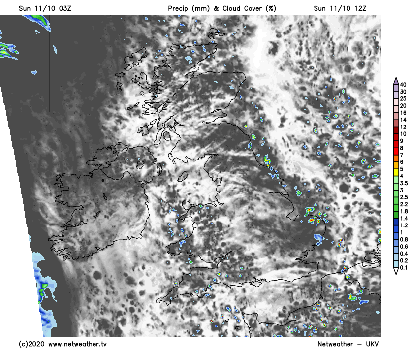
A North West wind will be fresh and blustery along North Sea coasts, before decreasing towards evening. But as winds turn into the South West or South across Northern Ireland, cloud will increase from the West through the afternoon bringing some rain later mostly towards Donegal. Top temperatures only 10 to 14C perhaps locally 15C briefly over a few sheltered parts of southern England.
It'll be a mostly dry evening, with any remaining showers along North Sea coasts quickly melting away. There'll be clear spells for much of the night in the East and South-East, and with light winds, it'll turn quite cold here with temperatures falling to around 4 or 5C. Further West it'll be milder due to cloud arriving through the night, with outbreaks of rain over Northern Ireland spreading to some other more western areas by morning, accompanied by a freshening southerly breeze.
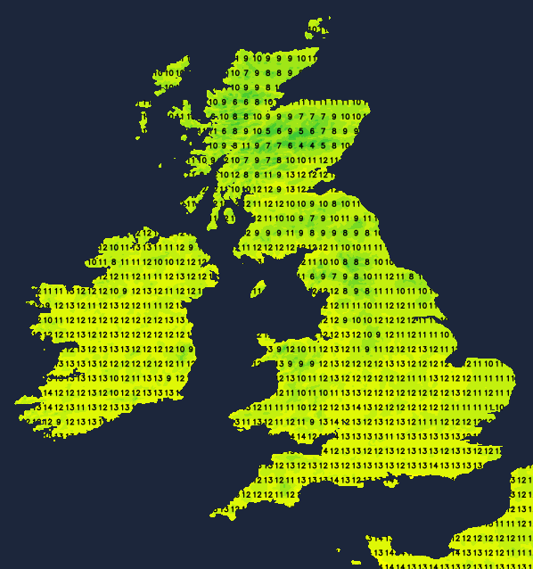
After a bright start in some eastern areas, the new working week begins very unsettled as a depression approaches Scotland. This'll bring bursts of locally heavy rain from the West eventually to most parts, but much of the day towards the South East will be dry. Northern Ireland, however, will be brighter once residual rain has cleared, with a mix of sunny intervals and scattered showers. There'll be a chilly southerly breeze ahead of the rain and an equally chilly North Westerly wind across Northern Ireland in a very cool day for mid-October, with temperatures generally getting no higher than 9 to 12C.
It continues unsettled after dark, with further outbreaks of rain. There'll also be a cold northerly wind developing later in most parts. Across Northern Ireland and in the far West skies should break in places, but there'll continue to be showers. The unsettled conditions should prevent temperatures from falling below 5 to 7C in most parts though.
As we move into mid-October conditions should improve with some sunshine, especially in the North and West. It'll remain chilly though, with ground frost and maybe a touch of air frost in some rural hollows under clear skies at night.