


This week's muggy warmth is fading but the start of next week looks much warmer.
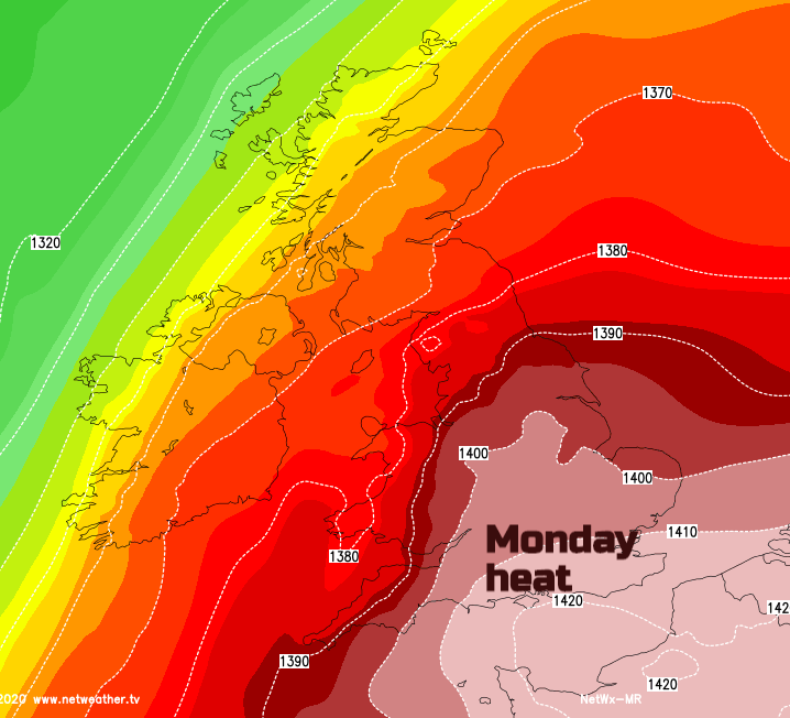
September temperatures will see ups and downs over the next week or so with a return to warmth widely through the UK, even heat for SE Britain. Once pulse starts on Sunday, peaking on Monday but lasting for eastern Britain into Tuesday and there are signs of another warm spell later next week. The outlook does include blustery conditions away from southern England. If you are sitting outside at a café or pub, watching socially distanced sports or just out for exercise the westerly winds will be noticeable especially the further north in the UK you are.
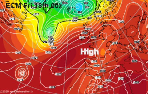
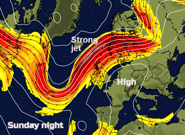
Whilst many parts of the UK see a dry spell, showers continue to whistle in from the NW with western Scotland particularly the NW Highlands getting clobbered with heavy and persistent rainfall over the next week. Sunday look particularly wet as what had been a zonal Jetstream moving straight across the Atlantic begins to meander. High pressure builds over France then central Europe for the start of the new week as low pressures move past northern Scotland at the weekend. Around the high, warm air will be dragged up from the south, lifting temperatures into the high 20sC for southern Britain, maybe tipping over 30C for London.
Further ahead, high pressure looks to build in from the SW, from the Atlantic later next week, dragging warmer air our way. The Atlantic has been seeing a very active hurricane season, so the dartboard low pressures are dotting the pressure charts adding uncertainty into the forecast model output.
The US has just seen an early winter storm with a dramatic temperature gradient around the Rockies. Temperatures in the 30sC one day then around zero the next. Red flag fire warnings with poor visibility and wildfire smoke changing to violent winds, thundery rain turning to snow with ice and winter weather warnings. Unusually early for a winter storm. These temperature contrasts affect the Jetstream heading over the Atlantic and so influence the low pressures that head our way and also the flows of air, either hot or cold over western Europe.
So some cooling this week as the warm humid air is pushed away to the SE by a cold front with a nip in the air early Thursday but warmer later in the weekend and early next week.
The UK September all-time record is a slightly ropey 35.6C from 1906 recorded at Bawtry, Hesley Hall (South Yorkshire) on 2nd Sept. Flintshire saw 32.3C the day before and Moray 32.2C with Armagh up to 27.6C so early September 1906 was astonishingly warm across the UK.


