


Sunny spells and more thundery showers in places today. Low pressure then arrives tomorrow and will hang around for the remainder of the week, bringing with it blustery winds, along with periods of showery and longer spells of rain.
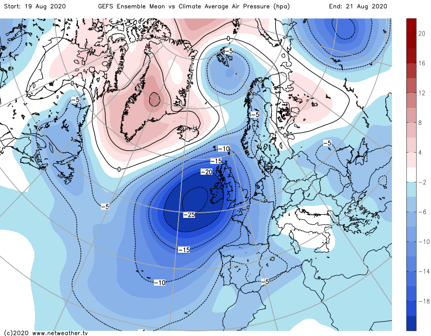
Although remaining unsettled, we'll see a change through tomorrow, in a freshening southerly flow. This'll be circulating a complex, and unusually deep area of low pressure for August, that'll eventually become centred to the West of Ireland. Embedded fronts then move North during the remainder of the week, bringing spells of rain or showery conditions more akin to autumn than late summer. It'll also turn blustery with gales in the West, but despite this, temperatures remain well up to normal.
We have some showers this morning across North West England, the North and West of Wales and towards the South coast. Others will develop some heavy perhaps with thunder, but they shouldn't be as widespread as yesterday, with a fair chance of missing them altogether, especially towards the South East. There's a lot of cloud about at the moment, but sunny spells are expected to develop particularly from late afternoon in central and southern parts. Across the North and East of Scotland, there's mist and low cloud, but this'll clear from all but the far North, where it'll remain dull, misty and wet in a North Easterly breeze. Elsewhere winds will be from the South or South West, with top temperatures 16 to 19C in the North and 20 to 24C further South.
The showers melt away quite quickly into the evening to give particularly England and Wales some sunshine to end the day., although over Scotland a scattering of showers may persist for a while. The rain should also eventually move away from the Northern Isles leaving most parts with clear spells overnight in a gentle southerly breeze, that may allow mist and a few fog patches to form in some rural areas. In the South, however, the lull will be brief, with rain and freshening winds already into the Channel Islands, probably spreading to some other southern coastal counties before dawn. It won't be a particularly cool night, with lowest temperatures mostly between 8 and 14C.
Northern areas begin dry and bright on Wednesday, with Scotland, in particular, seeing some sunshine. Here apart from the odd shower, much of the day should be dry, but with cloud increasing in the South later. Elsewhere cloud and rain, heavy in places, will be moving up from the South, eventually reaching Northern Ireland and northern England by or during the afternoon. A Southeast or southerly wind will freshen becoming strong in the West later, with top temperatures mostly in the range 17 to 22C.
The rain continues to march northward into the evening, spreading to the whole of Scotland after dark. For most, it's then a wet night, with the rain heavy at times making it misty over hills, despite a fresh southerly wind that'll be strong in the West where gales are likely especially in exposed areas. Later in the night, the South West, much of Wales and central southern England may see skies breaking, but there'll continue to be a scattering of blustery showers. It'll be a very mild night though, with temperatures generally not falling below 10 to 16C.


