This is a time of pressure re-organisation as we see the UK's recent cold spell (which can be common in the second week of May), replaced by increasingly warm weather, particularly into the new working week.
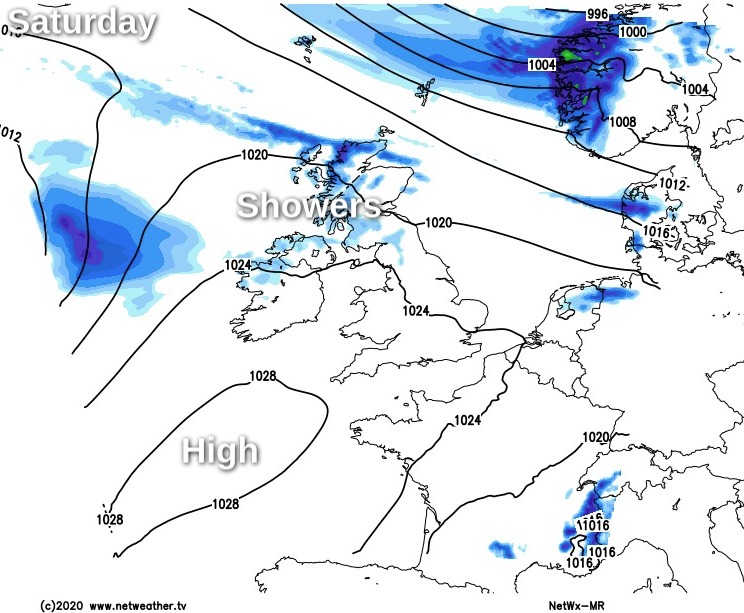
This is a time of pressure re-organisation as we see the recent cold spell (which can be common in the second week of May), replaced by increasing warmth, particularly into the new working week. For this weekend though Scotland and Northern Ireland will see some rain, while much of England and Wales are dry and finer, under the influence of an anticyclone just to the South West of Britain.
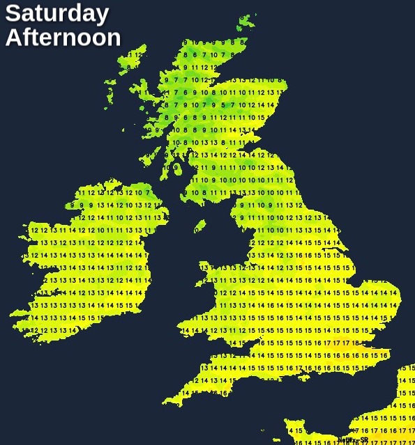
We have a good deal of cloud across the country at the moment, but there are already breaks, particularly over the North and North East of England. As skies continue to break, most of England and Wales, particularly the South and East will see some sunshine today, and it'll continue dry. Top temperatures of 15 to 18C won't be too far from normal depending on cloud cover, in a mostly light Westerly breeze.
The North and West of Scotland and Northern Ireland have a few showers at the moment and continue to see some through the day. Elsewhere the emphasis will be on dry weather with skies brightening to give some sunshine, this mostly over the East and South of Scotland and across Antrim and Down at first. Through the afternoon though Northern Ireland becomes overcast with some rain moving in later on a freshening a South West wind. Top temperatures 12 to 15C but only 7 or 8C across the far North, where a Westerly wind will be quite fresh for a while.
While Cumbria may see a little rain or drizzle moving in later, most of England and Wales continue dry during the evening and overnight. Cloud amounts will vary, but there'll be further sunny spells to end the day, especially in South, with clear intervals after dark in just a light West or South Westerly breeze. It could turn chilly and misty in the South towards dawn, but temperatures generally shouldn't fall below 4 to 8C.
Across Northern Ireland, it'll be a misty evening and night with further rain or drizzle at times. It'll stay mild though in a moderate or fresh South to South West wind, with temperatures falling no lower than 10 or 11C. The North of Scotland and later Dumfries and the West should also see some rain, while Fife, Lothian and The Borders stay mainly dry with skies breaking at times. It'll be a relatively mild night here too in a West or South Westerly breeze, where temperatures are unlikely to fall below 6 to 8C.
Sunday will be similar across much of England and Wales, with the best of the sunshine in the East and South. Most parts stay dry, but cloud may bring some rain to Cumbria, the Isle of Man and the far West later. It'll become quite warm in a South Westerly breeze, with temperatures reaching 17 to 21C depending on cloud cover. The East and South should be bright for a while, but much of Scotland and Northern Ireland have occasional rain. Here too it'll feel quite mild despite a moderate or fresh South Westerly wind, with temperatures reaching 13 to 16C but it'll be colder in the far North.
Little changes into the evening and overnight, with Scotland and Northern Ireland seeing further rain at times. Parts of northern England could also see patchy rain, but elsewhere it continues dry with broken skies in the South. It'll be a mild night though in a South Westerly wind, with temperatures unlikely to fall below 7 to 11C.