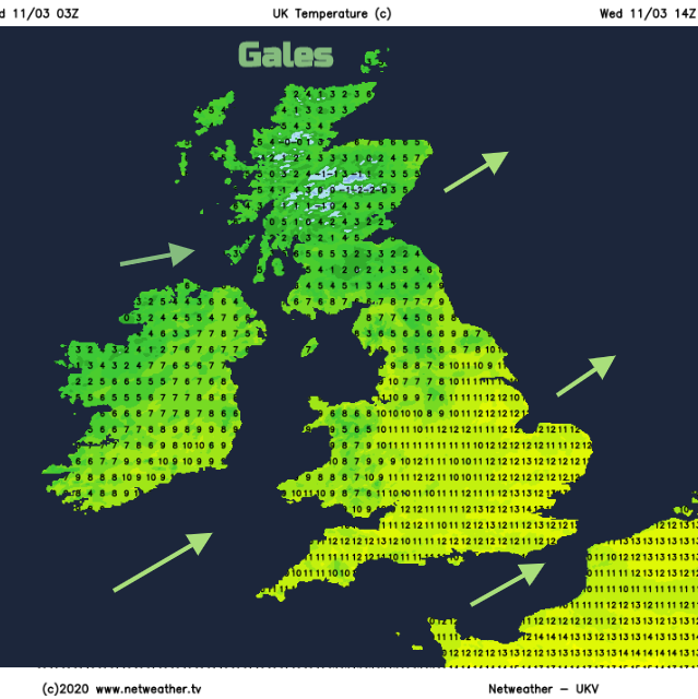
Still mild today for England and Wales but a chill in the brisk winds. Gales for the north. Snow and Ice warnings into Thursday.
The River Severn has peaked at Hereford after all the rain on Monday, but concerns remain along the Severn at least until the weekend. There are still numerous flood warnings for rivers and now coastal concerns with the 2nd highest spring tides of the year, this week. Lots of water on and in the ground, water still coming down in the rivers, brisk winds pushing sea waters against the coasts and a supermoon with extra high tides. It's all going on this week and the Thames Barrier has been in operation with its monthly test still due on Thursday.
It has been very mild in those SW winds. 16.5C at Kew Gardens in London and also Cambridgeshire on Tuesday. However colder air is on the way, already over NW Scotland and this will spill southwards by Thursday morning and bring a chill to the air, especially in the brisk winds. There are snow and ice warnings out for Northern Ireland and northern Britain and gales, even severe gales are forecast for northern Scotland.
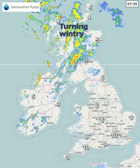
This morning the Channel Islands remain grey and damp as a frontal band lurks over northern France. A collection of lows near to northern Scotland and south of Iceland will bring strong winds and plenty more showers our way. Clusters and lines of rain showers with hail and later hill snow will whistle in from the north and west making good progress inland, particularly over Scotland. Eastern Britain will see plenty of brightness, even sunshine but with blustery winds. Southern Britain will have a bit more cloud but still be fair with sunny spells and a moderate SW wind.
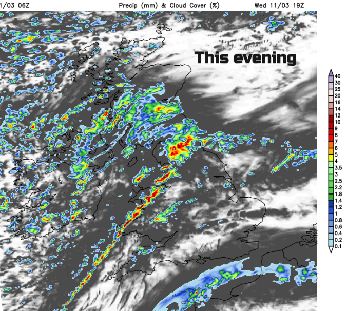
By late afternoon heavy showers will be over Ireland with a noticeable dig of cold air over Scotland, gales, even severe gales for the Northern Isles with flood warnings for Orkney.
“FLOOD WARNING Spring high tides, storm surge and strong westerly winds combined will bring a risk of coastal flooding for the next few days. “ SEPA
The showers over Ireland will spill over Northern Ireland and then Britain with squally conditions, some hefty downpours, hail, hill snow and tricky conditions on the roads. This pushes SE as a cold front, with more wintry showers behind. And the temperatures fall from double figures down to 3C in the south and just below zero in the north
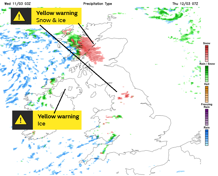
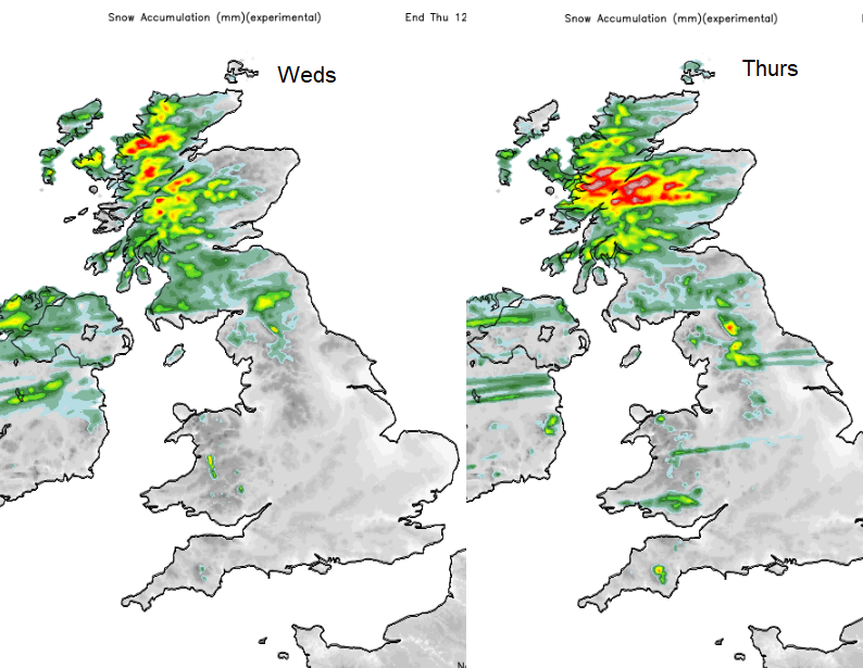
The Yellow warnings from the Met Office run from Wednesday evening through until 10am on Thursday morning, to get past the morning rush. The main area for lying snow on Thursday morning will be inland Highland across to western Grampian. Other areas of northern Britain could have seen a slight covering overnight, mainly over the hills. Thursday will be a cooler day as one of the low centres moves southwards and brings rain, strengthening winds and a little hill snow. There will be a lot of dry, clear weather about by Thursday evening, but this area of showers does move southwards, fading over East Anglia around midnight into early Friday.
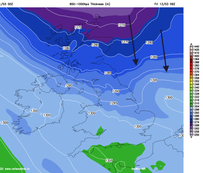
By then, much colder air will be flowing down from the Arctic as the low moves away eastwards. This will bring snow showers to Aberdeenshire and a few wintry flurries for Friday morning to NE England and North Yorkshire.
Overall Friday becomes a fine, sunny day. It will feel chilly until the winds die down, but it looks dry and bright. Enjoy that, the weekend looks more unsettled again.
More on this weeks flood warnings