Remaining unsettled this week, with a strong jet stream in charge which will shift north Tuesday allowing temperatures to rise to 17C in the SE, but cooling down by Thursday as jet moves south.

Published 09:30 09/03/20 Warning updated 12:35
It was yet another unsettled weekend across the UK, with wet and windy weather moving through Saturday night followed by sunshine and showers on Sunday. The unsettled theme continues this week, thanks to a strong jet stream in the driving seat powering across NW Europe. After a bright start this morning, wet and windy conditions will spread across all parts by the evening. Cloud and patchy rain will gradually clear to showers on Tuesday, becoming very mild towards the southeast, with temperatures reaching 16-17C. Showery for the rest of the week, with colder air moving in across the north on Wednesday, turning showers wintry, the colder air reaching all parts on Thursday.
A strong zonal jet stream across NW Europe will keep the weather unsettled through the coming week, very mild at first but cooling off from the northwest as the jet stream sinks south.

Today
For now, a bright but chilly start to the new week, temperatures have generally held up above freezing overnight, though across the far north and northeast temperatures have fallen close to or below freezing – allowing a frost to form. It’s not a completely dry commute this morning, with a few showers across central and northern areas, these should soon clear, with most ending up dry with sunny spells for the rest of the morning.

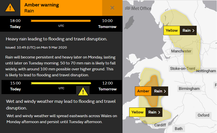
Clouding over across western areas early afternoon, with rain arriving across Ireland and N. Ireland this morning spreading across western areas of mainland Britain by mid-afternoon, rain locally heavy, especially over higher ground in the north and west – with Met Office yellow warnings in force until noon tomorrow for the rain perhaps leading to an increase in flooding issues.
Staying dry across the far east for much of the afternoon, but clouding over with rain arriving from the west by early evening. Becoming quite windy with arrival of the rain, the strengthening southwesterly wind bringing in mild air though, temperatures reaching 8-11C.
Staying windy and wet at times through tonight, more persistent and heavy rain spreading east this afternoon and evening clearing the east to more showery conditions overnight. A mild night, especially in the south.
Tuesday
Starting cloudy and windy, with patchy rain or drizzle in places on Tuesday, but rather mild in the south. Perhaps remaining cloudy across the southwest and far south of England, with further patchy light rain or drizzle, but further north across England and Wales we should see some drier and brighter conditions with sunny spells develop – especially towards eastern England – where temperatures look to reach 16 or 17C. Lots of blustery showers packing in across western Scotland and NW England though, turning wintry by evening as colder air moves in, drier and brighter towards eastern Scotland. Windy day, with gales around western coasts.
Wednesday
A spell of rain, perhaps heavy locally, spreading east across southern England Tuesday night before clearing before dawn on Wednesday. Then a bright and blustery day for most, with scattered showers which will be most frequent across the north and west – showers wintry across the north with snow over higher ground as colder air continues to spread in here, but remaining mild across the south with temperatures reaching 11-14C.

Another blustery day with sunshine and showers on Thursday, perhaps merging into more organised bands of showers spreading east for a time, colder air spreading south across all parts by then, with showers wintry in the north. Temperatures reaching 6-9C in the north, 9-11C in the south.
After some showers for some first thing, dry and cold and perhaps frosty start for others, Friday may perhaps see fewer showers with more in the way of sunshine, as brief ridge of high pressure builds in.