There’s been a few articles knocking around over recent days suggesting a major Sudden Stratospheric Warming (SSW) could be in store in February, similar to what occurred in February 2018 and led to the infamous ‘Beast From The East’ late in the month into early March that year.
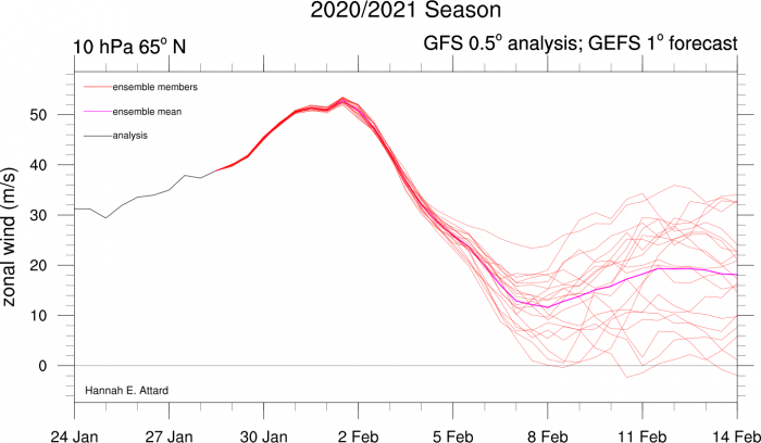
The American GFS (Global Forecasting System) weather model did, for a few runs the end of last week into the weekend, hint at a technical SSW in early February – whereby the current strong westerly zonal winds in the stratosphere over the arctic reverse and become easterly at the 10 hPa level.
My tweet on Saturday showed GEFS 10mb wind mean wind reaching 0 m/s then reversing.
This occurs in tandem with a sudden warming in the stratosphere often triggered by strong poleward energy in upper waves forming further south at mid-latitudes. A cold stratosphere over the arctic is characterised by strong polar vortex of strong zonal winds, where cold air is locked up over the arctic by a strong jet stream further south circumnavigating the northern hemisphere. However, when the stratosphere warms suddenly, the polar vortex is weakened and can split or get displaced. When this occurs, cold air that was bottled up over the arctic can shift into North America and/or Europe, as areas of blocking high pressure develop in place of the polar vortex, pushing cold air south to the mid-latitudes.
However, the GFS has over the last few days or more backed away from a reversal, but still shows the stratosphere over the arctic warming with a subsequent decrease in zonal winds.
GFS/GEFS has over last few days backed away from a major SSW with wind reversal:
The GFS and European ECMWF model have still been indicating a strong warming from the North America side of the pole leading to a brief split of the stratospheric polar vortex before it merges back together as one vortex again, but becomes displaced towards Russia and NE Europe in early February.
Warming from the N America side in the stratosphere displacing the stratospheric polar vortex towards Russia/Europe
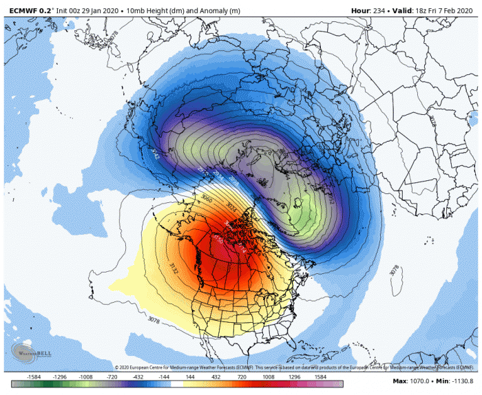
So it looks possible that the Polar Vortex will become displaced toward us, but it is not clear yet how this may manifest down through the stratosphere into the troposphere – the lowest level of the atmosphere where our weather happens. The stratosphere has been strongly coupled with the troposphere since late December, with a strong stratospheric polar vortex mirrored in the troposphere, driving a strong zonal westerly flow across the Atlantic and onto into NE Europe, bringing bouts of unsettled, wet and windy conditions to the UK, but also spells of high pressure when the jet stream has drifted north at times. But overall with the flow from the west, it has been rather mild.
It is uncertain whether the stratospheric PV will remain coupled with the troposphere if it is displaced in early to mid-February. There is also hints from longer range model output of a ‘second warming’ later in February, which could further weaken the stratospheric PV with a reversal of zonal winds and next time perhaps split the PV. But this way off and not certain to occur. If a major SSW (reversal of winds at 10 hpa) occurs later in February, given the lag time of response in the troposphere, we could see a cold start to Spring, like 2018. But, it’s worth noting that SSW events do not always lead to cold and snow in the UK like the one in early 2018. And this year the stratospheric polar vortex is particularly strong, so even a second warming may not be enough to allow a major SSW to occur.
In the meantime, the models are giving forecasters a bit of a headache for next week, with uncertainty as early as 6 days away. The GFS and EC models have over several runs over recent days been hinting at a very cold northerly flow developing Tuesday and Wednesday week, GFS was particularly cold on a few runs, with temps at 850 hPa widely below -10C across the UK for a time and surface temperatures struggling into low single figures for day maxima. With this cold air a risk of snow showers too.
However, the last 3 run of GFS have got rid of the cold northerly because it fails to build a strong mid-north Atlantic high but rather has a flatter westerly flow with the briefest colder northwesterly polar incursion early-mid next week before milder westerlies return. As of the 00z run out this morning, it’s only the 00z ECMWF that holds on to the northerly, whilst GFS, GEM (Canadian) and ICON say no to a northerly next week.
The divergence between the models post day 6 - appears to be how they handle the deepening winter storm off the east coast of US and Canada over the weekend and into next week. EC drives the deep low north up through the Labrador Sea towards Baffin Bay, driving WAA (Warm Air Advection) north over the Atlantic towards Greenland and Iceland building a strong mid-Atlantic ridge. Whilst the other models have the low moving NE towards tip of Greenland keeping the upper flow across the N Atlantic a lot flatter.
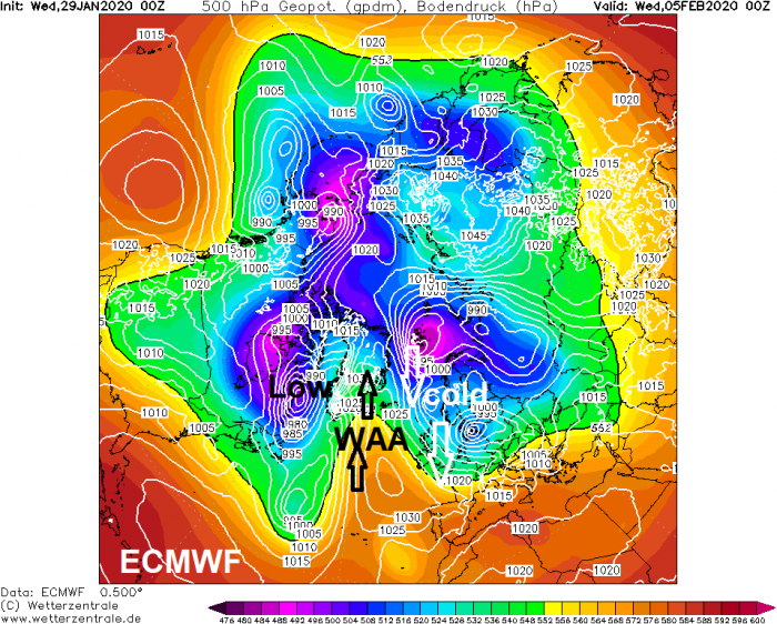
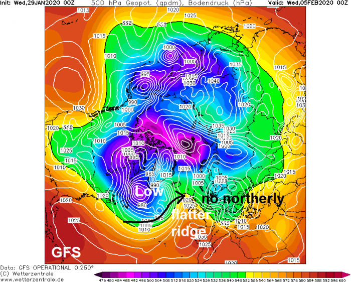
If a northerly does happen, it may likely only last for a day or two, before the amplified Atlantic ridge to the west helping it occur collapses to allow an unsettled, milder, zonal westerly flow to return. If we don’t see a major SSW and no strong signal from other drivers of our weather that can force a pattern change, such as the Madden Julian oscillation (MJO), to bring blocking high pressure at higher latitudes to bring sustained colder weather and risk of snow, then February is likely to continue the mild or very mild theme of January, with bouts of unsettled weather at times.
Some of the longer range model output, such as the ECM weeklies that update on Monday and Thursday and the Met Office's GloSea, indeed show a conitinuation of zonal westerlies with mild conditions through February across much of Europe, including the UK. So drawing a conclusion, a continuation of what we've have since the New Year seems the most likely outcome, for now. But the odd brief cold incursion, with snow mostly confined to the north, can't be ruled out.
Loading recent activity...