


A cold and frosty start for England and Wales in a dry week. Mild and breezy further north. UK atmospheric pressure did reach 1050.5. No snow and little rain in the forecast for next few days.
High pressure has brought dry weather across the UK this weekend and will continue over the next few days. This has been an intense area of high pressure reaching 1050.5hPa on Sunday evening at Mumbles Head, south Wales. We don’t see over 1050 very often in the UK. The last time was in 1957. It doesn’t particularly mean much, day to day for our weather but if you like your weather stats, it’s a tick in a box.
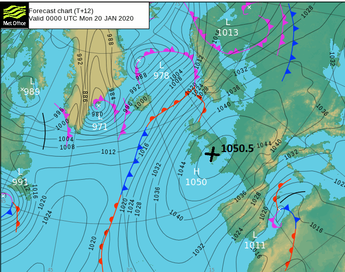
High pressure brings settled weather, dry with light winds. Highs can be cloudy, bringing anticyclonic gloom under the grey covering but also can be sunny and clear. In winter this leads to cold nights and frost, sometimes fog too. The UK this morning has quite a variation, although it is dry everywhere. Southern Britain, with pressure still at 1049hPa, is cold and frosty with light winds. The northwest of Scotland is mild and cloudy with a starting temperature of 10C and strong west winds.
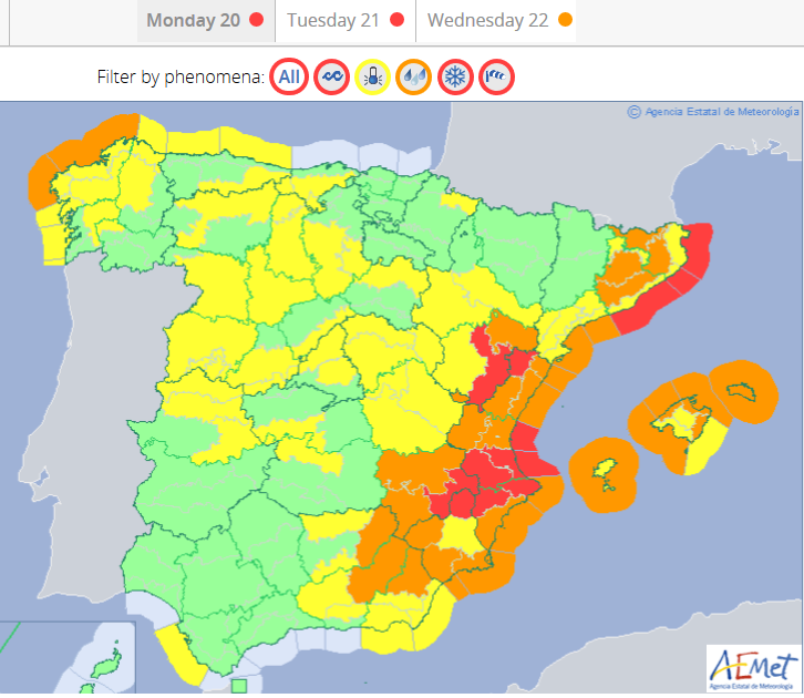
Whilst the UK sits under this large high pressure, Atlantic low pressures are still heading to Iceland and then up towards Scandinavia but also further south with Spain and Portugal having a wet and windy weekend. There are still weather warnings for the Costas, Mallorca and Ibiza for the start of the week.
Today
It is another frosty start across much of England and Wales, with some high cloud, light winds and a bright start. There have been some incredible skies at sunset and sunrise, just glorious. However, with still, trapped air any particles get stuck in the stagnant conditions. Pollution levels in great London on Monday are showing as high or very high on the DEFRA forecast and again midweek.
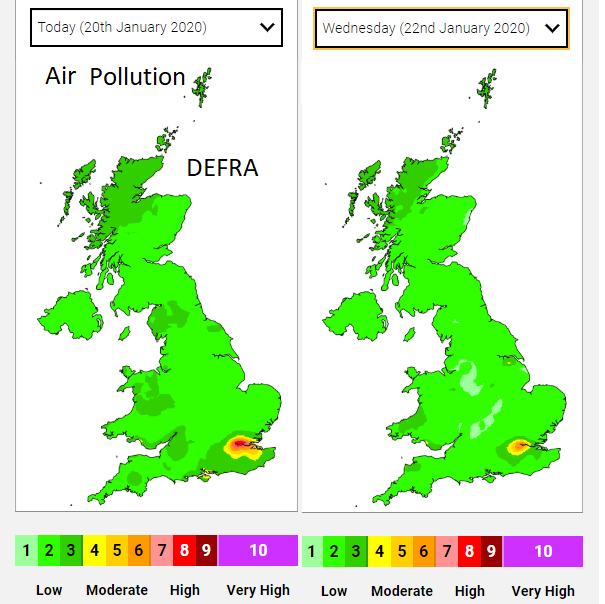
“light winds and areas of fog in the south may inhibit dispersal of locally-generated pollution and lead to areas of High air pollution, more likely over larger urban centres.” DEFRA
The Moray coast could see double figures today in the brisk SW winds. Elsewhere temperatures creep up to 6 or 7C, feeling chilly in the wind but okay in the still sunshine.
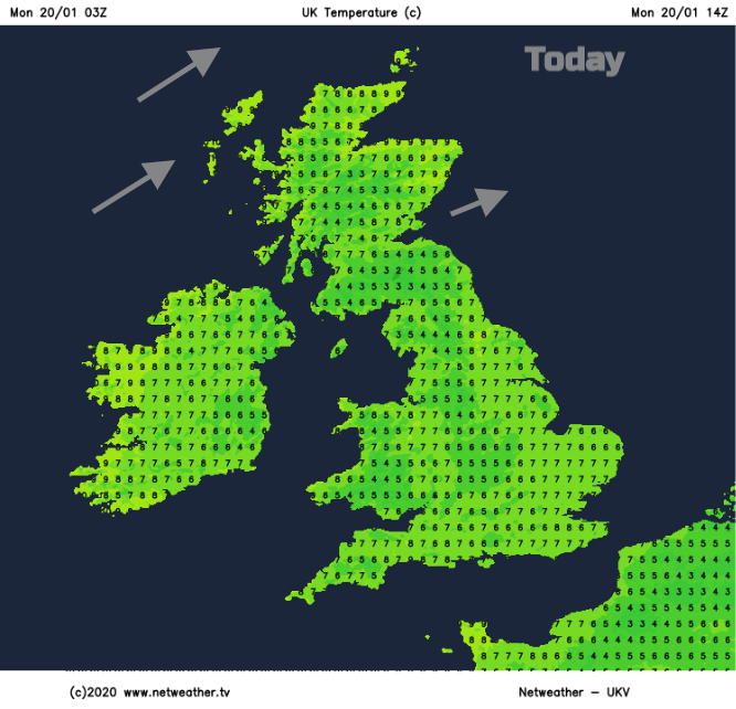
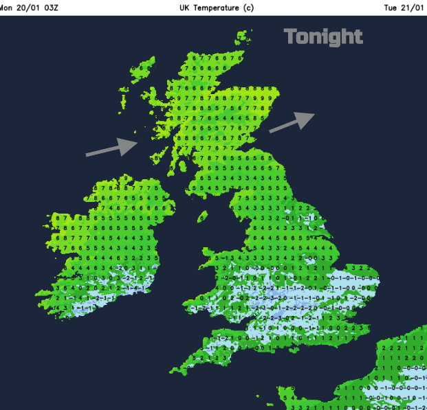
There is no snow in the forecast and very little rain away from NW Scotland. Cloud will thicken later today for the Western Isles with rain arriving this evening into the NW Highlands and then the Northern Isles tonight. Again, tonight it will be mild in the north and cold & frosty in the south.
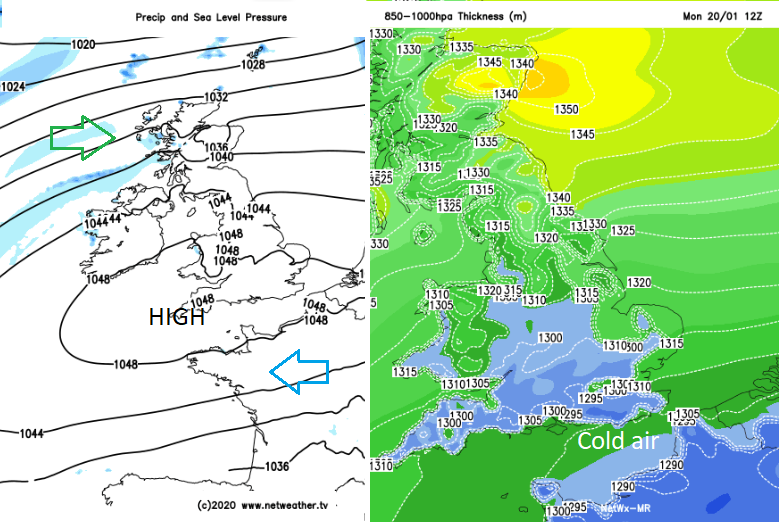
Cold air from the continental land mass of Europe will keep temperatures low over southern England to start the week. The high stays with us over the next few days but eases down to 1028hPa by Thursday. This keeps the weather dry for many, there will be more cloud over the next few days so not the blue skies and sunshine from this weekend. More unsettled weather will manage to make inroads into NW parts of the UK with more cloud, outbreaks of rain and blustery winds. Northern Ireland and Scotland will be mild on Tuesday with the milder air creeping into northern England during the afternoon. Only southern counties of England should see a frost on Tuesday night with lighter winds across the UK on Wednesday
It looks more windy and mixed in the south by Saturday and mild again. No snow in the forecast for the next few days although the unsettled weather next weekend from the Atlantic could turn more wintry particularly over the hills and mountains.


