
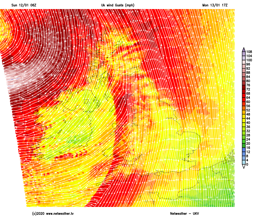
Atlantic systems will regularly attack the British Isles next week, bringing spells of very wet and very windy weather. The first one - Storm Brendan - arrives on Monday.
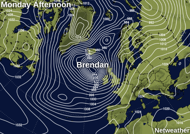
Atlantic systems just keep on coming, in what has been a particularly mild and windy January so far. And there's still no sign of winter in the immediate future, with a stormy week in prospect, starting with Storm Brendan on Monday. So expect more topsy-turvy weather, with warnings of heavy rain and damaging winds in the next few days, especially across the North and West.
We currently have an area of showers some heavy, across Wales, parts of the North West and the Midlands, that'll move East through the morning before clearing into the North Sea. There are also showers some heavy giving hill snow over Scotland, but these too will fade, to leave most parts with sunny spells and just the odd shower these mostly in the West. It's still very mild in the South where temperatures have remained in double figures overnight, but generally, it'll be somewhat colder today.
A West or South Westerly wind will be lighter than yesterday, but still strong and blustery at first in some of the more heavier showers. Despite a chilly feel, it'll remain mild in the South with temperatures between 9 and 11C. Further North though, you can expect to get no higher than 4 to 6C.
After dark, it becomes mostly dry, with any remaining showers towards South and West facing coasts fading. There'll be clear spells especially across central and eastern areas and with lighter winds for a while, East Scotland, in particular, will have a slight frost, as temperatures generally fall to between -2 and +5C. Later in the night however there'll be a change, as a southerly wind freshens over Northern Ireland ahead of yet another Atlantic system moving in from the West.
Most parts start the new working week dry, with some sunshine for much of the day in the East. Northern Ireland soon becomes wet and windy, however, with heavy even torrential rain in places and severe gales, this eventually spreading to all but some central and eastern areas through the day.
Damaging gusts of wind from the South of 70 to 80 mph seem likely in the West, with 40 to 50mph gusts also possible in the East later, where it'll turn wet soon after dark. It'll feel cold in the wind, particularly in the East at first but temperatures will rise slowly, to reach 7 to 11C.
England, Wales and South East Scotland have a wet and windy evening with gales and bursts of heavy rain. Broken skies however already over Northern Ireland and the North and West of Scotland will spread to all but the South and some eastern parts overnight, but still with a scattering of blustery showers some heavy in the West giving squally winds and hail. While decreasing a little later in the night, a boisterous South West or southerly wind should be too strong for any frost problems, with temperatures unlikely to fall below 4 to 7C in the North and a mild 8 to 10C further South.


