Northern France has warnings for thunderstorms for the start of May. With favourable ingredients of warm moist air, high CAPE and a warm front, southern Britain could see storms, hail and lightning.
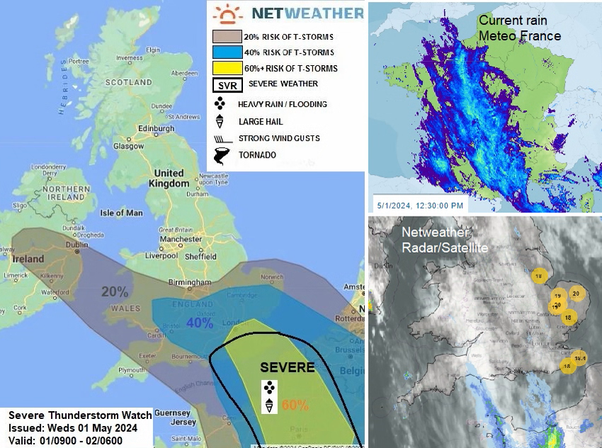
Thunderstorms with frequent lightning and hail could reach the English Channel on Wednesday night with further outbreaks for southern Britain into Thursday. Meteo France has yellow and orange warnings for heavy rain, flooding and storms today and into the early hours of Thursday as this is where the heart of the convective action will be.
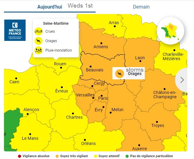
'a series of strong thunderstorms…thunderstorms late afternoon/next night over a north-eastern quarter of the country…In Normandy, cumulative precipitation will be occasionally significant.’ ‘storms are expected to be virulent with torrential precipitation, hail and squalls. Electrical activity (lightning) will also be marked.’
There is a low pressure west of Ireland which brought rain to western Britain and Northern Ireland on Tuesday and has left a band of cloud over Britain for Wednesday morning. A low pressure over Sardinia in the Mediterranean is bringing very unsettled weather with thunderstorm warnings extending up to the Italian Alps today. The warm front from this low pressure extends up through France into eastern England and is important for tonight’s developments.

A low centre will develop over central mainland Europe and help push the warm front westwards over England and Wales tonight. The models do vary, some show developments over Belgium tonight combining with the ongoing severe convection over France which would influence what could head towards southeast England
The Arome model almost keeps a shield over Belgium with the torrential rain over France and what looks like an MCS, a Mesoscale Convective System heading northwest towards Dorset as a trail of developing storms is shown on the UKV model almost along the M4 in the small hours.

Warm air will lift on its journey westwards over the cooler, more dense air. With colder air aloft there will be elevated convection. The lifted warm air will be unstable, with development away from the stable surface layer this is where thunderstorms would form. These are different to surface-based thunderstorms which often develop in the heat of the day, as solar radiation warms the ground. Often elevated thunderstorms show lots of lightning but the rainfall at the surface can be less than suggested on model outputs. It can evaporate between the cloud base and the surface so the radar imagery and observational ground truth may be at odds. Tornadoes are unlikely but hail is more likely in elevated storms. There is plenty of moisture available tonight with warm, high theta-w air and plenty of CAPE (Convective Available Potential Energy). It relates to the instability in the atmosphere and the updraught strength in thunderstorms.

Along the warm front will be pulses of heavy rain, perhaps isolated lightning this evening. As the action gets going over northern France and Belgium later in the day
“forcing engaging the plume and undercut of drier air from the NE at the surface generating an arcing area of thunderstorms across N France during the evening, which could produce large hail (3-5cm diameter) and flash-flooding – before the storms then move N and NW towards SE England / E Anglia overnight.”

“There is some uncertainty over the extent of thunderstorms when they arrive across SE England – however, given large CAPE values forecast – storms may produce isolated large hail (2-4cm diameter), intense rainfall leading to flash-flooding, frequent cloud-to-ground lightning and strong wind gusts.”
The models have varied over recent runs and for those wanting to chase the storms this evening and see the lightning show it may (as usual) just be a case of watching the radar later today. Staying mobile and nowcasting.
.png)
We could see surface-based convection in France possibly developing an MCS and then edging towards the English Channel this evening. For France, this would bring the threat of torrential rain, flash flooding and frequent lightning, from Wednesday afternoon. CAPE values are surprisingly high for this early in May.

There will be the elevated convection over southern parts of Britain which is likely to bring frequent lighting. A line of storms is forecast to move over southern England into the Midlands and Wales. There is a lot of uncertainty so if thunderstorms worry you don’t assume that they will affect where you live. For those excited by thunder and lightning, you will probably already be painfully aware of the delights and disappointments. This set-up does have some encouraging ingredients, some that would look more suited to summer, with the higher CAPE values. Also, the main action should be after dark, for some even as the sun begins to rise but there is some claggy low cloud to consider if you are hoping for a good view.
By Thursday morning the overnight bands will have reached Wales and southwest England with the potential for some heavier bursts of rain to start the day around the Bristol Channel. Further showers are showing on the UKV for southern counties of England and again they drift west/ northwest towards Cardiff by lunchtime,

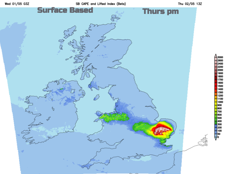
With increasing Surface Based (SB) Cape over Anglia, there is the possibility of thunderstorms developing inland for eastern Egnland. Further showery rain will affect Wales and in the early hours of Friday there could be another thundery pulse reaching Norfolk This looks to spread westwards over the north Midlands, north Wales and northern England on Friday.
The UK Met Office has issued two thunderstorm warnings, they are for different times over southern England. Rain and lightning could still occur outside these regions. The matrix with these yellow warnings is showing Unlikely and Medium Risk.
“One of the most notable aspects of thunderstorms can be the localised nature of the impacts they could bring. This in particular can be the case with rainfall amounts, with big differences in amounts that fall from one place to another – and over only a very short distance.” Met Office Matrix Guide
The most severe weather is forecast for northern France up to the coast and possibly reaching across southern England tonight and early on Thursday. Other areas of England and Wales could see heavy downpours, thunderstorms and lightning tonight, or on Thursday. As always with showers and storms areas in between will miss downpours or hail but could see lightning in the distance.
Severe Convective Forecast May 1st/2nd
Storm and Convective discussion thread on the Netweather community forum