Issued 2024-05-11 21:36:59
Valid: 11/05/2024 2200 - 13/05/2024 0600
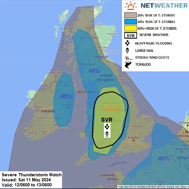
... SEVERE WATCH FOR SW ENGLAND, E WALES, MIDS, SERN N ENGLAND...
Upper trough moving eastward over the far N Atlantic will amplify as it comes up against upper-level ridge extending north from central Europe to the east of the UK. A shortwave trough will move NE across the UK on Sunday ahead of main upper trough to the west and will engage a plume of warm moist air (theta-w of 14C+) advecting NW across England and Wales. Surface heating and cooling aloft from the southwest with approach of upper trough will steepen lapse rates and increase instability within warm/moist conveyor, with model forecasts of 1000-1500 j/kg MUCAPE during the afternoon. Shortwave trough moving in across SW England/Wales early afternoon before ejecting NE across England will be the trigger for thunderstorms to develop here initially before spreading or developing further north across the Midlands and N England through the afternoon and into the evening. Despite fairly weak deep layer shear, the large amount of CAPE forecast across southern and central areas along with fairly strong southerly winds aloft will support robust storms capable of producing isolated large hail and isolated damaging wind gusts, also lightning could be quite prolific, with frequent C-G lightning in stronger storms. There will also be the risk of localised flash-flooding. The risk of a thunderstorm is more isolated towards SE / E England where forcing will be weaker with shortwave trough only glancing to the west, but isolated brief storm or two can’t be ruled out here. A severe thunderstorm risk area has been delineated across E Wales, Midlands and southern N England for the risk of large hail and flash-flooding.
Further north and west, breeze convergence and falling heights will likely support bands of heavy showers and thunderstorms to develop and move NNE across western Scotland and the eastern side of Ireland + N. Ireland through the afternoon and evening. CAPE not forecast as large as across England and Wales, but nonetheless, storms could produce hail and localised flooding.
Issued by: Nick Finnis
Issued by the Netweather forecast team whenever there is a risk of storms or severe convective weather, these discussion based and in depth forecasts will highlight the areas at risk and give an in depth description of the risk and the factors surrounding it.