There is still a lot of water about after widespread flooding for northern England on Thursday. Drier today, rain for SW UK Saturday with frost and hill snow for a colder weekend and Remembrance.
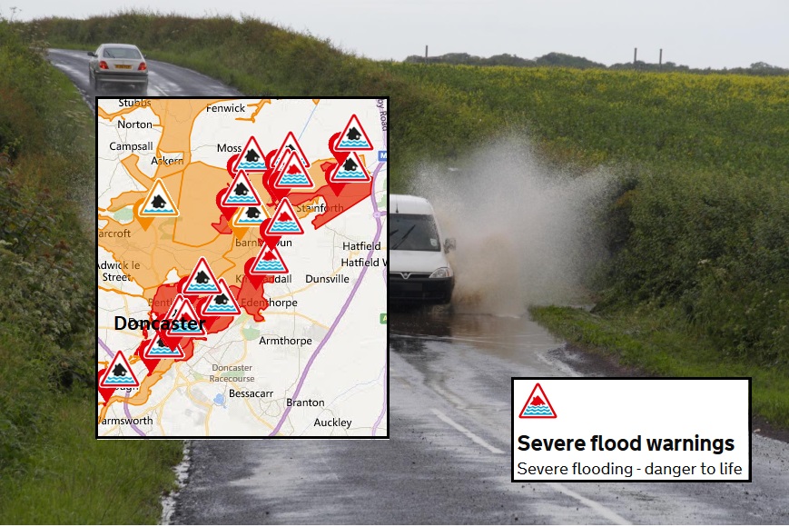
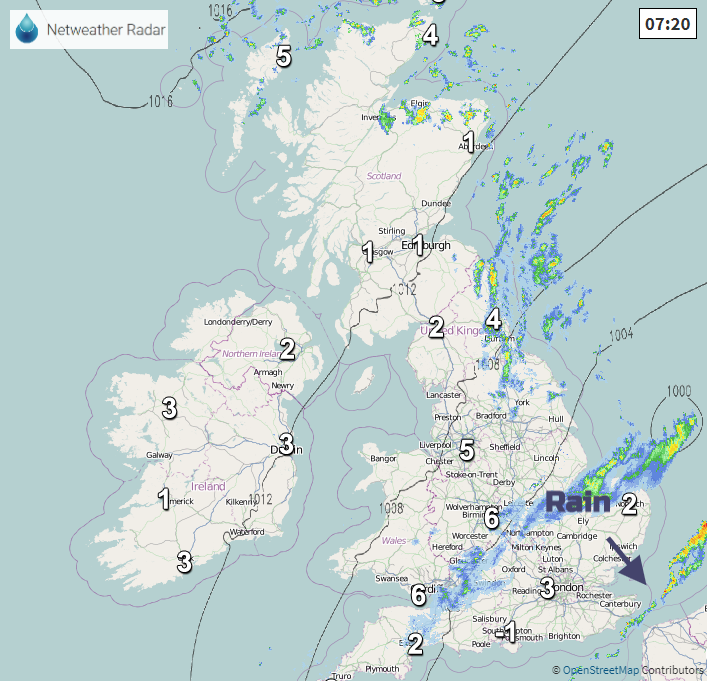
Over 100mm of rain fell yesterday in parts of northern England, Sheffield saw major flooding and received it’s November average rainfall amount in 24 hours with roads submerged and people having to stay at Meadowhall shopping centre overnight. The River Don has three severe weather warnings on it with major flooding at Rotherham and there was flooding disruption at Worksop, Notts, in Lincolnshire and on many railway lines with problems this morning. Police and councils and the Environment Agency are asking people to avoid certain areas and to take care near flood waters even though the rain has now cleared.
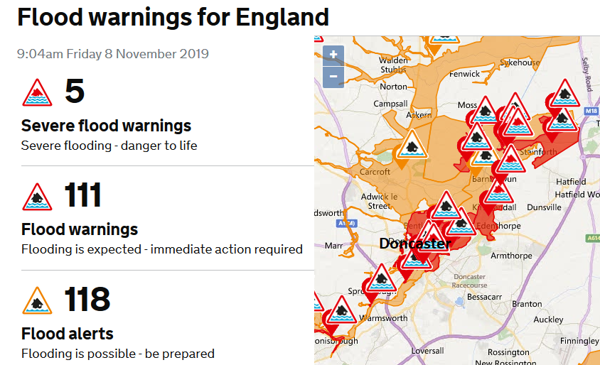
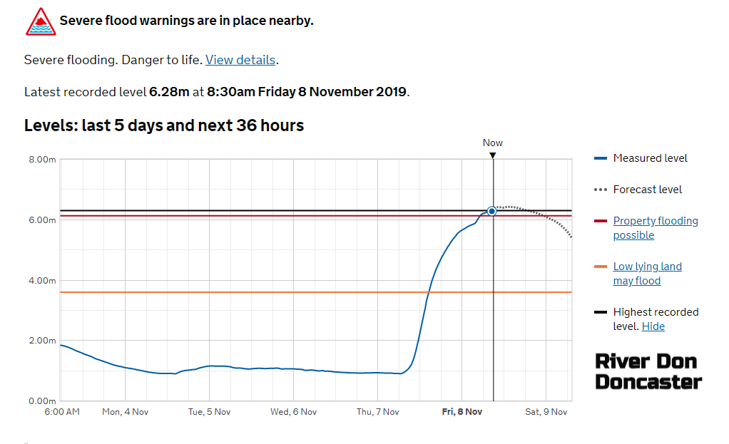
Severe flooding - Danger to life Near Doncaster -River levels have risen as a result of the persistent heavy rainfall. Consequently, flooding of Willow Bridge caravan park is expected this morning, flooding of property and roads across Kirk Bramwith, across South Bramwith is possible this morning, 08/11/19. Flooding has caused significant impacts in the Barmby Dun Area and Kirk Sandall and residents are being asked to evacuate. River levels will remain high today. Environment Agency
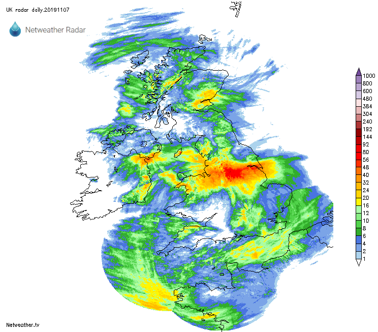
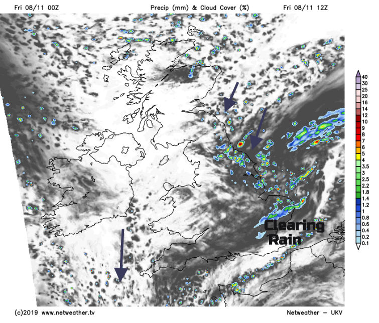
It will be drier today for the flood-hit areas, although there is still plenty of water flowing down from the hills. It is colder today, there was even some snow over the tops of the Peaks last night and there is a real chill in the damp air today. The problematic band of rain is edging south-eastwards, over East Anglia as the low centre moves away. Showers are being drawn in over NE England/SE Scotland towards Yorkshire with some hefty downpours and there is a similar feed further north into Grampian. These are accompanied by a cold NE /N wind off the North Sea today and there has been frost in places. It is going to feel colder by the end of the weekend with more frost.
There is fog this morning for southern Britain with grey cloud and murk around of the frontal band. The band of rain is fading as it eases away southwards. After the huge amounts of rain yesterday, today is quieter, a lull before the next band of rain heads in from the west for Saturday. That won’t be anywhere near as bad.
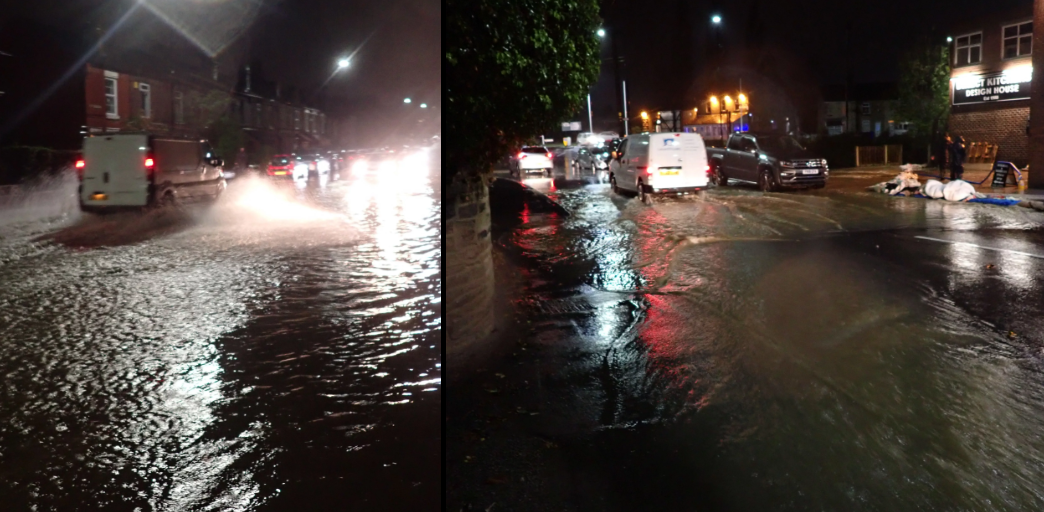
Ecclesfield - photo Onding from Netweather Yorkshire and E England Regional forum
The eastern showers and the last of the rain band will bring an unsettled day to East Anglia, with a scattering of showers shifting down over eastern England too. For most, it will be a fair bright day with sunshine but feeling chilly in the wind. Temperatures of 6 to 10C
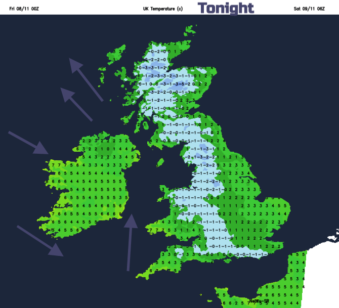
There will be a fresh north wind blowing for East Anglia as southerly winds being to freshen for western Scotland and Ireland overnight. These will accompany the incoming weather front but in between it will be clear and cold with a risk of frost for Britain. So, a fine start for many early on Saturday but the band of rain will already be over western Britain, clearing Northern Ireland but followed by hefty sharp showers around the low centre
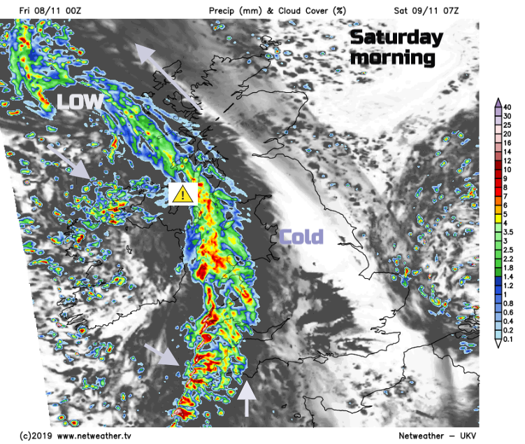
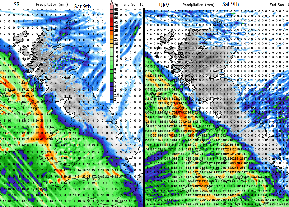
A yellow warning for rain has been issued for parts of Northern Ireland on Saturday. "A band of heavy rain will spread east across Northern Ireland overnight into Saturday morning, becoming slow-moving across eastern areas. 20-30 mm of rain is expected widely across the east, with 40-50 mm possible, most likely in County Down." There could also be lying snow over the Welsh mountains and a little for the tops of the Pennines and Scottish mountains on Saturday, it will be clear and cold for northern Britain and a fine day for eastern England.
Another cold night with frost and for Sunday there will be a lot of dry and bright weather around, but it will still feel cold. Fine for Remembrance services. Any early showers over the far SE of England should clear but there will be one or two still feeding off the North Sea clipping eastern Britain, so worth a look at the radar.
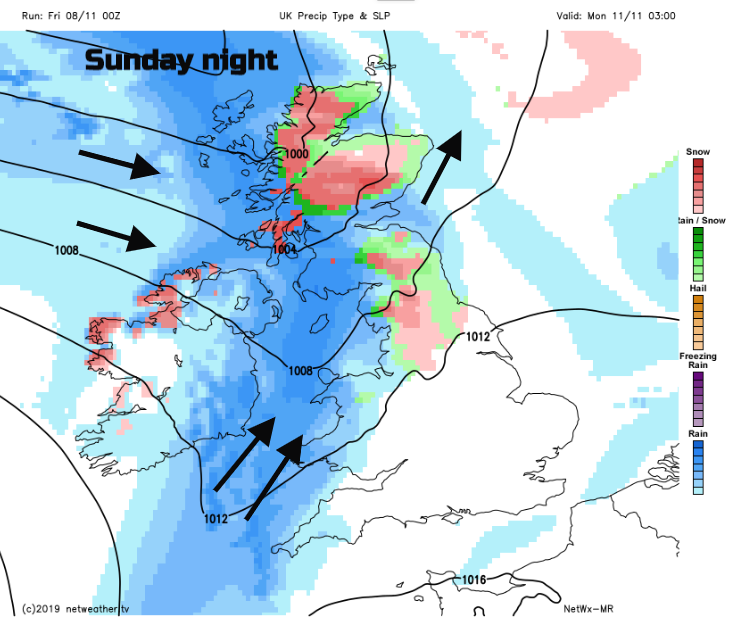
Monday now looks much more unsettled for services on the 11th. A band of rain with hill snow moving across the UK with blustery winds. Staying cold.