
Uncanny timing with the arrival of the Autumn Equinox the weather turns increasingly unsettled with wind and rain at times in the coming week. Cooler than of late too.
It’s the autumn equinox tomorrow, the start of astronomical autumn, and the weather seemingly wants to play its part in marking the arrival of autumn too. After a week of high pressure in charge, with many places dry, sunny and warm by day, a breakdown to unsettled conditions is already underway. High pressure that’s been over us retreats east to eastern Europe over the next few days. This allows Atlantic low pressure systems to take over the reins over our weather. So, from today and through the coming week and perhaps beyond it is looking changeable across all parts, as a series of Atlantic weather systems rattle in off the Atlantic, bringing spells of wind and rain or showers at times, cooler too than the last few days, though there will be some drier and sunnier spells too. Fuelling the return of unsettled weather off the Atlantic will be the remnants of ex-Hurricane Humberto arriving to the west by Tuesday, though no more than spell of wind and rain for many.
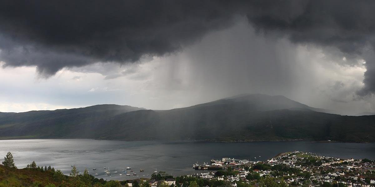
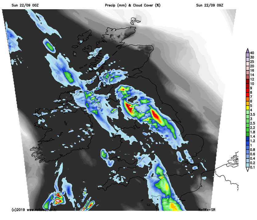
For now, the breakdown of the recent settled weather is coming in with a bang this morning across parts of central and NW England – where there has been thunder and lightning waking some up from quite early on, just when some want a lie in.
A band of heavy and thundery rain is quite extensive across NW England and SW Scotland, which may cause some localised flooding. Thundery showers trail southeastward from this large area of rain across the Midlands and SE England. This band of thundery rain or showers will continue to spread north across northern and eastern England and up into southern Scotland through the morning, in what is plume of quite warm and humid but unstable air. Further west, a band of heavy and perhaps thundery rain in association with a cold front moving into the west will spread north and northeast across the island of Ireland, Wales and southern England through the morning too. In between these areas of rain will be some drier and brighter conditions. Northern Scotland mostly dry and bright this morning, apart from a few showers in the west.
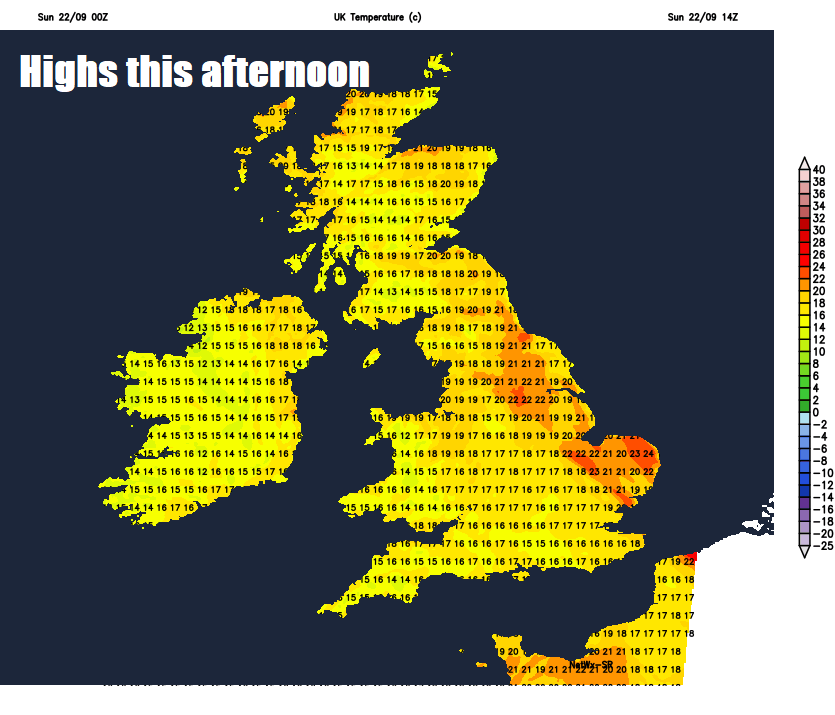
Through the afternoon, many areas at risk of catching a spell of rain, locally heavy and thundery, or perhaps a heavy thundery shower passing through. But there will be some drier and bright or sunny spells too. Temperatures reaching 17-18C across Scotland, N. Ireland and NE England, elsewhere, across England and Wales, a warmer 19-24C, highest temperatures towards eastern England – where it will still feel muggy.
Rain, locally heavy and thundery, clearing northeast of England this evening to leave much of England and Wales mainly dry with clear spells tonight, but a risk of a few isolated showers in the west. Rain, perhaps locally heavy and thundery, clearing north across Scotland overnight, followed by drier conditions with clear spells. A few mist and fog patches forming in places where skies clear, temperatures falling to around 11-13C.
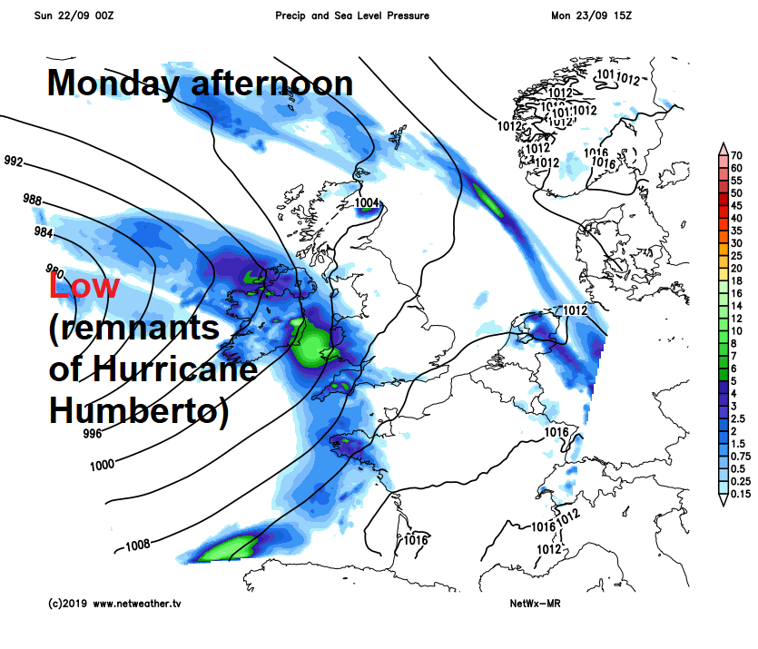
An area of low pressure formed from the remnants of ex-Hurricane Humberto will move in to the west of Ireland on Monday, bringing outbreaks of rain and strengthening winds across Ireland, Northern Ireland, Wales and SW England during the day, elsewhere, it will be a mostly dry and sunny day, though a few scattered showers could develop across Scotland. Temperatures reaching 17-18C in the west where the cloud and rain pushes in, 17-20C across Scotland, northern and eastern England where it stays sunny.
Showery rain spreading northeast across most parts Monday night and becoming increasingly windy too. Then for Tuesday, a windy and often cloudy day, with some showery rain around at first, before an area of more persistent heavy and perhaps thundery rain spreads northeast across England and Wales through the morning and into the afternoon, followed by sunshine and showers across the south and west. Scotland not such a washout, with sunny spells and a few showers, though heavy rain may arrive in the south later.
Wednesday, Thursday and Friday will see a slow-moving area of low pressure parked close to the northwest of Britain, bringing further showers or longer spells of rain and it will be often windy too.


