A low pressure linked to what was Hurricane Dorian is heading for Iceland and will bring wet and windy weather tonight and on Wednesday. Remnants of TS Gabrielle mean UK rain on Thursday.
Old tropical systems will add some extra energy into our weather this week. What was Hurricane Dorian will bring rain tonight from the NW and blustery winds, then the remnants of Tropical Storm Gabrielle gives the UK some rain on Thursday but nothing severe and the end of the week looks much more settled.
There is lingering low cloud over eastern Britain and fog inland this morning. Winds are very light, and temperatures have fallen down to 0.6 in Co. Down, +1C in the Highlands and +3C in North Yorkshire. Co Down saw the top temperatures on Monday, up to 18.0C. Today southern Britain will be warmer, up to 21C. The thicker cloud around the Firth of Forth is producing a little rain and trying not to forget a fading old front, there could be the odd shower for Sussex later this afternoon.
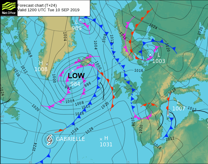
The morning fog will disappear as more sunshine appears and the breeze picks up a little. For most of the UK little changes, it remains a fine day with bright or sunny spells. However away to the NW things are changing and a low pressure linked to what was once Hurricane Dorian is skirting by. This will pull up some warmer air, bring heavy rain from the west and resulting in a blustery middle of the week for everyone.
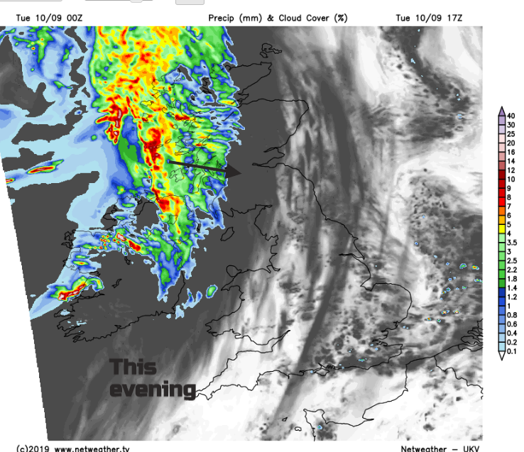
Weather fronts associated with this extratropical low sweep across the UK with gales for the coasts in the far north and west. For Tuesday evening there will be southerly gales for the Western Isles and the Minch with gusts over 60mph. Northern Britain and Northern Ireland become windy overnight as the rain spreads SE. Two pulses of rain move across Britain. The warm front over East Anglia and the SE to start Wednesday and the weakening cold front over Wales and the Peak District, still heading SE and warmth in between with a lot of cloud. To the north, there are clearer skies, sunshine, a scattering of showers in the NW and fresh winds. The winds veer from SW to westerly but ease off in the south as pressure tries to build in.
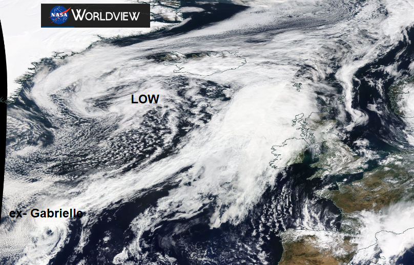
That might have been it for unsettled weather, the high could have taken over, but there is a delay thanks to Tropical Storm Gabrielle. The current situation out in the Atlantic -
1100 PM AST Mon Sep 09 2019 Gabrielle: the cloud pattern now has a dishevelled appearance that is becoming more reminiscent of an extratropical low pressure system. However, the tropical storm has maintained a very robust surface wind field.
Gabrielle is now well embedded in the high-latitude westerlies, and an additional increase in forward speed toward the northeast or east-northeast is expected over the next 2 days. By 72 hours, Gabrielle is forecast to dissipate near the northern British Isles. With much colder water and stronger south-westerly shear ahead of the cyclone, extratropical transition now appears likely to occur within the next 12 hours.NHC
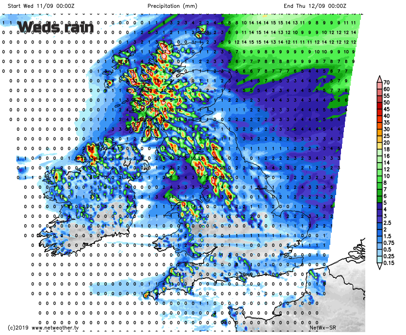
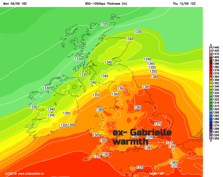
What was Gabrielle will bring a spell of rain and stronger winds to the UK but also warmer air with temperatures into the mid 20sC. Nothing severe, there aren’t any warnings out, but just a burst of wet, blustery weather nipping across Northern Ireland, southwest Scotland, NW England and NW Wales. There will be some rain for SW Britain and NE England as the fronts move through, but it will come and go quite quickly as the winds freshen. The winds then veer to the NW and overnight it turns colder.
By Friday high pressure will have taken hold, bringing more settled weather to most of the UK. There will be a chilly start thanks to the clear skies between the fading cold front clearing the far SE and more cloud with dampness for the far north of Scotland. With light winds for England and Wales, temperatures will reach the high teens and low 20sC. Mid-teens for Northern Ireland and also for Scotland but with brisk westerly winds picking up.
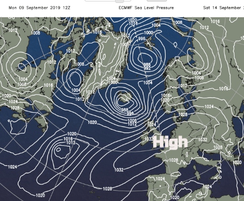
A deep low pressure heads towards Iceland on Saturday bringing blustery winds and rain to the far NW of the UK. Away from that there will be a lot of fine, dry and sunny weather which looks to last into next week. Temperatures stay around average and there will be more nippy nights. So, settling down for the middle of September.