
High pressure will ensure a mostly dry and fine weekend, but nights will be chilly. Unsettled at times next week, as the remnants of two ex-hurricanes pay a visit.
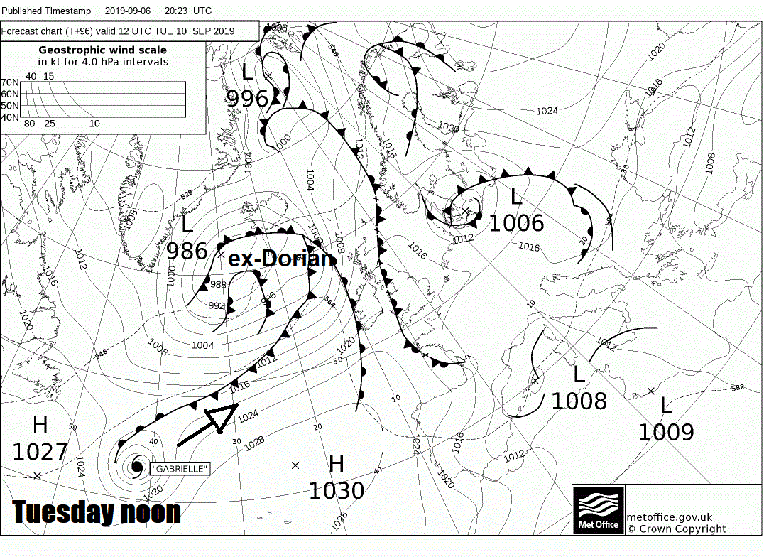
Hurricane Dorian made landfall over Cape Hatteras in the Outer Banks of North Carolina’s Atlantic coast on Friday, bringing hurricane force winds and also a storm surge bringing flooding to low lying areas. Dorian is now racing northeast off the eastern seaboard of the U.S. today, weakening but still bringing tropical storm force winds to SE Massachusetts and hurricane force winds across parts of Nova Scotia and Prince Edward Island tonight – where it is expected make another landfall. Dorian then transitioning into an extratropical depression as it continues across New Foundland.
The low pressure remnants of Dorian will then continue to track east across the North Atlantic, eventually passing between Iceland and Scotland on Wednesday morning, but bringing nothing particularly out the ordinary for early Autumn, other than a spell of wet and windy conditions. Also, there is Tropical Storm Gabrielle intensifying over the Atlantic, likely to be a hurricane for a time, before becoming an extratropical depression as it is picked up by the jet stream and tracks towards the northwest of Britain, for now, looking like another innocuous Atlantic depression, but will bring another spell of wet and windy weather on Thursday.
So next week is looking to turn increasingly unsettled and windy at times, as we see the remnants of two ex-Hurricanes passing by. But this weekend is looking mostly dry and settled in contrast, as a ridge of high pressure builds in from the southwest across Britain. Though it will still remain on the cool side by day and nights will turn chilly too. A reminder that we are now entering Autumn.
High pressure builds in this weekend, meaning for most it will be fine and settled with sunny spells
.gif)
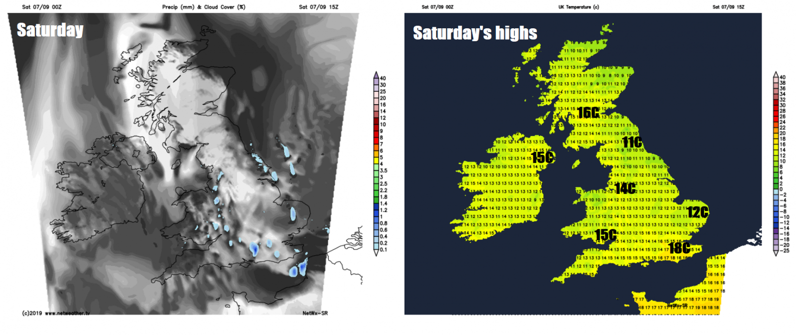
For now, there’s a fair bit of cloud around this morning drifting down on a northerly breeze, especially across England, Wales and Northern Ireland, where it is producing some well-scattered showers. Northern and western areas seeing the best of the sunshine. But many places will have a dry morning, with increasing amounts of sunshine, as the early cloud begins to break and early showers clear. This afternoon dry and fine for most with sunny spells and areas of cloud drifting south, most will stay dry, but a few showers are possible across Wales, Midlands, SE England and East Anglia. A brisk cool northerly wind down the eastern coastal areas of Britain will mean temperatures will be lowest here, with temperatures reaching 11-15C at best, away from the east coast temperatures reaching 16-19C, but still on the cool side for early September.
A mostly dry but cold night to come, thanks to mostly clear skies and a cool northerly flow, temperatures widely falling into single figures away from the west, low single figures across eastern Scotland central and northern England – where we could see some pockets of frost in rural areas by dawn. Thicker cloud and milder air moving in across Northern Ireland and western Scotland, with some patchy light rain or drizzle arriving by dawn.
.png)
So, a nippy start to Sunday morning, but for those taking part in the Great North Run in Newcastle, it’s looking to stay dry and sunny and for much of Britain Sunday will be fine and dry with sunny spells and variable amounts of cloud building. The exception will be across the northwest, as a warm front moving off the Atlantic brings thicker cloud with mist over hills and coasts across northern and western Scotland along with Northern Ireland, perhaps with some patchy light rain at times. Cool again, temperatures reaching 15-18C.
A cold front will push in from the Atlantic on Monday, bringing cloud and outbreaks of rain, locally heavy, across northern and western parts in the morning. An area of low pressure looks to develop in a kink in the front slowing progress eastwards of the rain, so some uncertain how far east the rain will spread for now. It could end up a rather wet day in the west, while eastern England could stay dry. Another cool day, temperatures reaching 14-16C at best.
Staying changeable and unsettled at times for the rest of the week, as the remnants of ex-Dorian bring wind and rain later on Tuesday and into Wednesday, the heaviest rain and windiest conditions in the north and west. Then the remnants of ex-Gabrielle likely passing somewhere over or to the north of northern Britain on Thursday, bringing more wet and windy weather. But there will be some dry and bright weather in between these systems and temperatures will generally be on the rise as winds turn to a warmer southwesterly, temperatures back into the low 20s Celsius across the south from Tuesday.


