


Cool & breezy next few days, dry in the south today, rain moving southeast for all on Friday. But the weekend looks to be mostly fine and settled as high pressure builds.
After days of bringing catastrophic impacts to the Bahamas, killing seven people, Dorian will pick up forward speed and head north to affect coastal areas of the eastern seaboard of the USA to end the week and eventually Atlantic Canada into the weekend. Yesterday it looked like Dorian would stay out at sea, but now the National Hurricane Center forecasts the Hurricane to track dangerously close to SE U.S. coasts from Georgia to Virginia today, bringing the potential for destructive winds, life-threatening storm surges and flooding rains – but nothing compared to the impacts seen over the Bahamas.
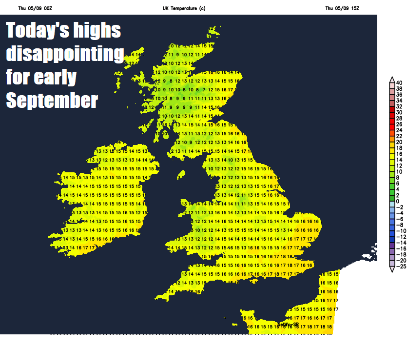
Back to home, much of southern Britain will have a fine and mostly dry day with a good deal of sunshine, once early cloud and some well-scattered early showers clear south. Across northern Britain, a warm front passing east will bring more in the way of cloud and some rain through the day after perhaps a bright start, though this should clear this afternoon to drier and sunnier conditions from the west. But for all it will be another cool and blustery day in a chilly northwesterly breeze, particularly across northern and eastern areas. Temperatures reaching 16-19C generally, though a cooler 11-15C across the Northern and Western Isles.
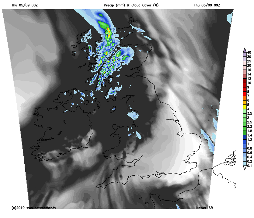
Southern England, East Anglia, Midlands and south Wales should stay mostly dry with clear spells but breezy overnight. But further north, a frontal system will slide southeast in association with low pressure moving southeast from Iceland, bringing thicker cloud and showery rain through the course of the night, followed by clearer but blustery conditions and showers across Scotland by the end of the night. Temperatures falling to around 10-12C generally, but East Anglia and SE England could be the chilliest parts of the UK, with temperatures falling into single figures locally in rural parts.
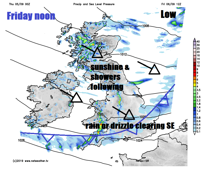
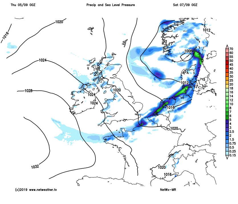
A breezy or windy day on Friday, as isobars tighten with an area of low pressure passing southeast to the north. A frontal system bringing rain to the north overnight will continue to slip southeastwards across Wales, central and southern England during the day, bringing cloudier skies with outbreaks of rain or drizzle. Rain becoming confined to southern England by late afternoon, drier with sunny spells following from the north elsewhere through the morning and into the afternoon, though some scattered showers likely for northern and western Scotland. Temperatures reaching 14-16C across Scotland and N. Ireland, 15-18C across England and Wales, so another cool day, exacerbated by the northwesterly wind.
The good news is high pressure will build in for the weekend and stay around throughout. Saturday is looking mostly dry and sunny, though cloud will build to bring a few showers across central and southern areas in the afternoon, but many here will miss them. Still a brisk northerly breeze down across eastern areas – so here the coolest temperatures, reaching 13-15C, lighter winds further west allowing temperatures to reach 16-19C.
High pressure building from the west this weekend keping the weather mostly settled and dry, bar the odd shower
Sunday, again, mostly dry and settled, with a good deal of sunshine for many. Perhaps more in the way of cloud across SE England and East Anglia, along with northern and western Scotland. Temperatures reaching 15-19C.
Rain and strengthening winds returning from the northwest on Monday, spreading southeast across most parts through the day. It looks like staying unsettled and breezy across the northern half of Britain through next week, but high pressure building close to the south may mean southern Britain stays mostly dry and becoming increasingly warmer, as winds switch to more of a southwesterly.


