Major fears for the northern Bahamas due to the continuing pounding by major Hurricane Dorian. SE coastal states of the US are already preparing for what comes next.
1 Sep 2019 - 12:00 UTC ...EYEWALL OF NOW CATASTROPHIC CATEGORY 5 HURRICANE DORIAN ABOUT TO HIT THE ABACO ISLANDS WITH DEVASTATING WINDS... ...LIFE-THREATENING STORM SURGE AND VERY HEAVY RAINFALL ALSO EXPECTED
1 Sep 2019 - 15:00 UTC ...DORIAN BECOMES THE STRONGEST HURRICANE IN MODERN RECORDS FOR THE NORTHWESTERN BAHAMAS. ...CATASTROPHIC CONDITIONS OCCURING IN THE ABACOS ISLANDS
The northern Bahamas have been subjected to a prolonged period of catastrophic winds and life-threatening storm surge. The small amounts of mobile phone footage from Abaco and Grand Bahama have been sickening; the amount of water, the damage from winds and then thinking about the chaos that will follow as people try to make contact and survive with minimal communications and infrastructure.
With this landfall statement, Dorian’s winds are estimated at an astounding 185mph. Only four storms on record (since 1851) in the Atlantic have estimated winds of 185mph or higher.
Hurricanes are categorised from 1 to 5, five being the most powerful. In the United States, people are told to evacuate and move inland, or for Florida, to move away from the coast but on these islands, this may not be possible for Bahamian people, for many reasons. Flights have been cancelled for several days. “Everyone there should remain in shelter and not venture into the eye.”
1100 PM EDT Sun Sep 01 2019 ...CATASTROPHIC CATEGORY 5 DORIAN MAKES LANDFALL ON THE EASTERN END OF GRAND BAHAMA ISLAND...
"Do not venture out into the eye, as winds will suddenly increase as the eye passes."
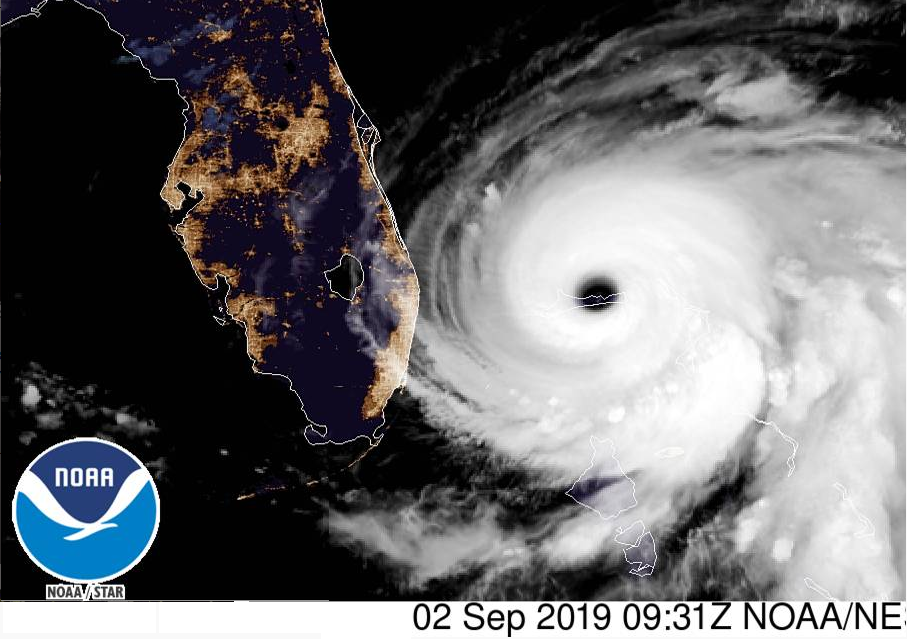
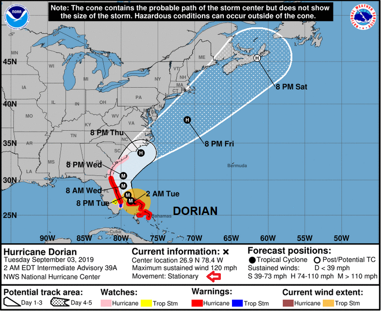
2nd Sept “On this track, the core of extremely dangerous Hurricane Dorian will continue to pound Grand Bahama Island through much of today and tonight. The hurricane will move dangerously close to the Florida east coast tonight through Wednesday evening. This expected slow motion will likely be devastating to the Great Abaco and Grand Bahama Islands since it would prolong the catastrophic winds, storm surge, and rainfall over those areas. The timing of the northwest or north turn is very critical in determining how close Dorian will get to the Florida peninsula on Tuesday and Wednesday." NHC
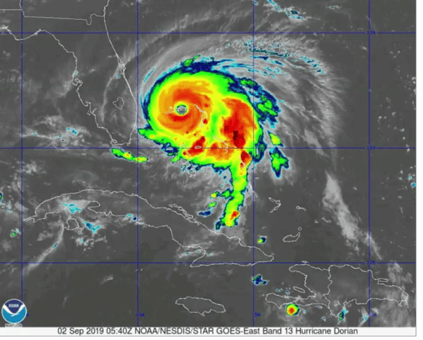
Dorian’s progress has been painfully slow, at times looking to stall, pounding the islands and continually at Category 5 strength. The winds, the storm surge raising water levels by as much as 18 to 23 feet above normal tide levels in areas of onshore winds on Grand Bahama Island, massive surf and dangerous waves, the heavy rain will result in flooding. Northwestern Bahamas...12 to 24 inches, isolated 30 inches.
Even once the core of the hurricane has left the Bahamas and the destructive winds pass, there will still be issues with heavy rain, hampering the clean up and rescue. This continual onslaught is phenomenal.
What next?
Category 5 hurricanes don't usually stay at that intensity for too long, so Dorian will weaken slowly in the next few days. However, it remains a scary storm with the potential to still drift towards Florida as states further north along the east coasts ready themselves. The forecast models show an increase in shear as Dorian tracks near Georgia and the Carolinas. This interferes with the structure of the cyclone and results in weakening.
DORIAN IS FORECAST TO SLOW DOWN AS IT APPROACHES THE EAST COAST OF FLORIDA TODAY, THEN TURN NORTH MONDAY NIGHT OR TUESDAY. ALTHOUGH THE CONSENSUS OF RELIABLE MODELS KEEPS THE CENTER OFFSHORE, SOME TROPICAL STORM FORCE WINDS ARE STILL POSSIBLE IN THE OUTER BANDS OVER THE NEXT FEW DAYS IN THE INTERIOR PORTIONS OF WEST-CENTRAL AND SOUTHWEST FLORIDA
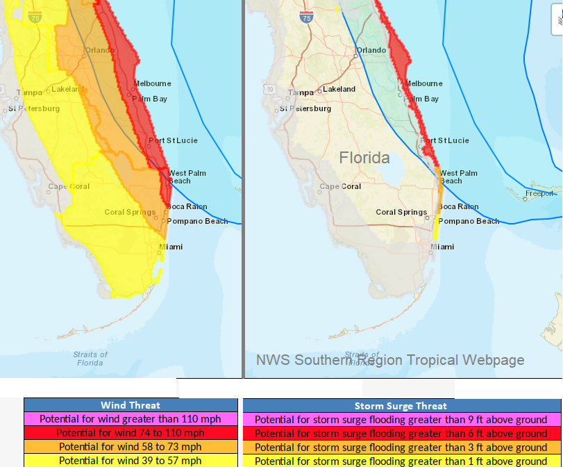
Life-threatening storm surges and dangerous hurricane-force winds are expected along portions of the Florida east coast through mid-week, and storm surge and hurricane warnings are in effect. Only a slight deviation to the left of the official forecast would bring the core of Dorian near or over the Florida east coast
There is an increasing likelihood of strong winds and dangerous storm surge along the coasts of Georgia, South Carolina, and North Carolina later this week.
Dorian is still marked as a Hurricane offshore from New Jersey by the weekend. It is likely to get caught up in the flow across the northern Atlantic, modifying and changing but still adding its energy into the atmosphere, which might end up over NW Europe. Its presence has already lowered the confidence for any forecast for next week as all of Dorian’s uncertainty gets passed on, into the forecasts across the Atlantic, particularly after the weekend.
More discussion in the forum about Hurricane Dorian.