


Last Thursday may be the all-time hottest day in the UK, according to provisional figures. No more heat over coming days, some rain for northern and eastern areas this weekend.

As we draw a close to a week of exceptional weather in the UK, with record-breaking heat building during the week followed by a dramatic thundery breakdown for some, the question remains over the official highest temperature recorded on Thursday. Initially the figure of 38.1C recorded at Cambridge was the highest temperature recorded, which falls just short of the current all-time record of 38.5C recorded at Faversham, Kent on 10th August 2003. However, it’s been revealed that another weather station at Cambridge University Botanical Gardens recorded 38.7C. However, this measurement requires quality control and analysis, by checking the site and equipment. But if validated, this higher temperature would set a new all-time record for the highest UK temperature ever recorded.
It will be some relief for many I’m sure, after the exceptional heat this week, that this weekend will offer much cooler and fresher conditions and there will some heavy rain around for some to moisten parched gardens, particularly for northern and eastern areas. And as head through next week, the weather looks to remain fairly unsettled, with low pressure in charge, with spells of rain Toda showers at times and although we won’t see a return of the exceptional heat we’ve seen, it will still be warm or very warm in the sunshine.
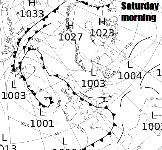
So today will see a slow-moving active frontal boundary lying down across eastern areas of Britain. This will bring a fairly broad band of cloud and outbreaks of rain covering much of Scotland, northern England, Midlands, eastern and southeastern England this morning, some heavy pulses of rain locally, perhaps bringing some thunder and lightning across parts of eastern England.
SW England, Wales and N. Ireland will be mostly dry this morning and also through the afternoon, the best of the brightness or sunshine across Cornwall, Devon, west Wales and N. Ireland, cloudier further east, with perhaps patchy rain developing later across north Wales.
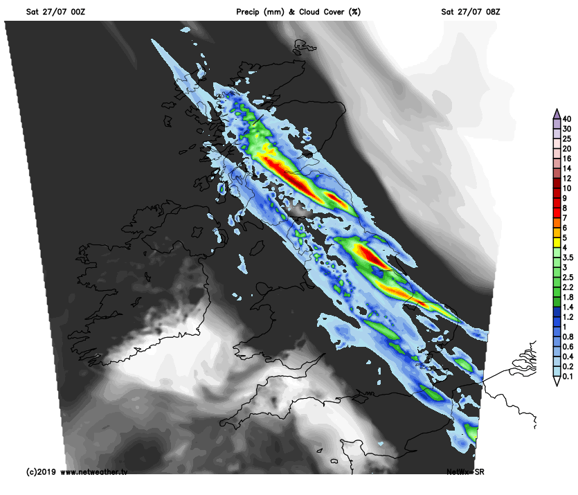
The outbreaks of rain, perhaps thundery locally, continuing across northern and eastern areas into the afternoon, so a soggy day for parts of Scotland, northern, central and eastern England. The rain will tend to clear eastern Scotland and later SE England, so becoming drier and brighter through the afternoon or early evening in these areas. But where the rain persists today, there is a risk of some localised flooding where we see heavier bursts of rain, the Met Office have yellow warnings for rain. Temperatures quite a bit down on recent days, reaching 17-20C in the north, 20-23C in the south, though it will feel muggy in the east still.
The slow-moving weather front across the north and east today will begin to pivot overnight, so moving further west across the north. This will spread outbreaks of rain further west to affect mostly west and SW Scotland, east of N. Ireland, NW England, Midlands and East Anglia. Some heavy bursts of rain across SW Scotland could bring some flooding. Drier either side of this rain band, some clear spells likely across SW England and Wales, but otherwise a largely cloudy night.
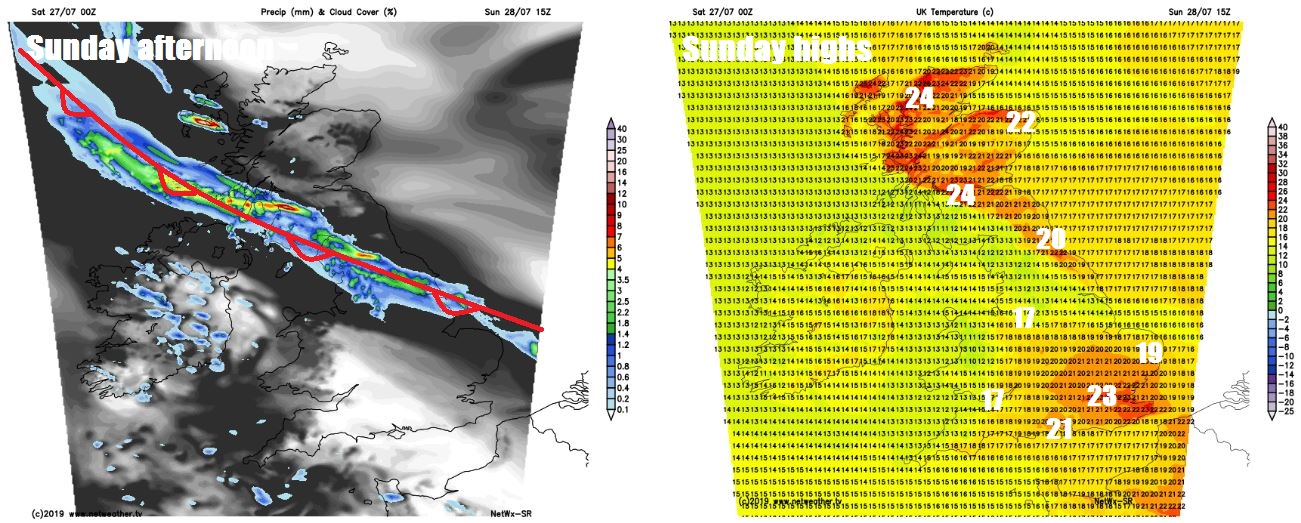
On Sunday, we still have that pesky weather front lying northwest to southeast across Britain, bringing cloudy skies and band of outbreaks of rain stretching across western Scotland, N. Ireland, northern England and on towards East Anglia, the rain heavy and persistent across SW Scotland and Cumbria – where we will continue to see a risk of flooding. Either side of the rain band, it will be mostly dry and bright or sunny. Temperatures a degree or two higher, reaching 20-24C where we see some sunshine, pegged back to 18-19C under the cloud and rain.
As we go into Monday, that weather front over the weekend will still affect Scotland, where it will drift north through the day, bringing cloudy skies and some showery rain. To the south across much of England, it looking likely a mostly fine and sunny day, however, an area of low pressure spinning in across the southwest will bring outbreaks of rain across SW England and Wales later. Temperatures reaching 19-24C.
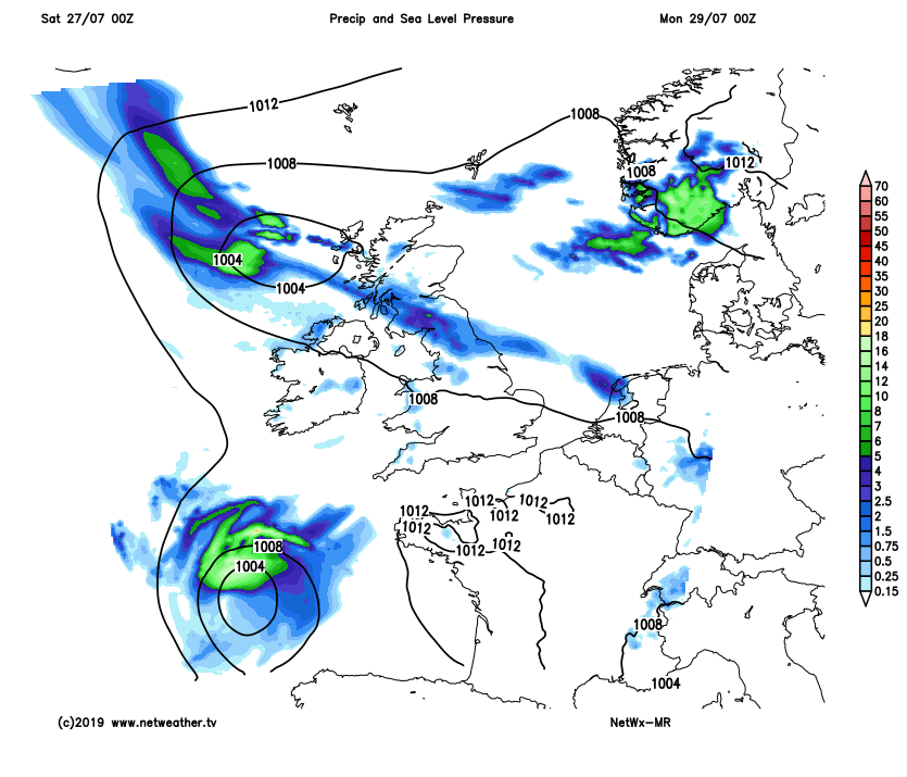
Tuesday will see an area of low pressure moving in across the south bring a cloudy and breezy day with outbreaks of locally heavy and perhaps thundery rain across England, Wales and southern Scotland. Showers likely to develop across northern, central and eastern areas on Wednesday, drier across the west and southwest. Fewer showers on Thursday and more drier and sunnier, then Friday is looking mostly dry, fine and sunny – warm too, but not return of heat.


