High pressure takes charge during the next few days bringing some fine, dry weather and also some hot, humid air by the end of the working week.
Updated Thurs 27th June
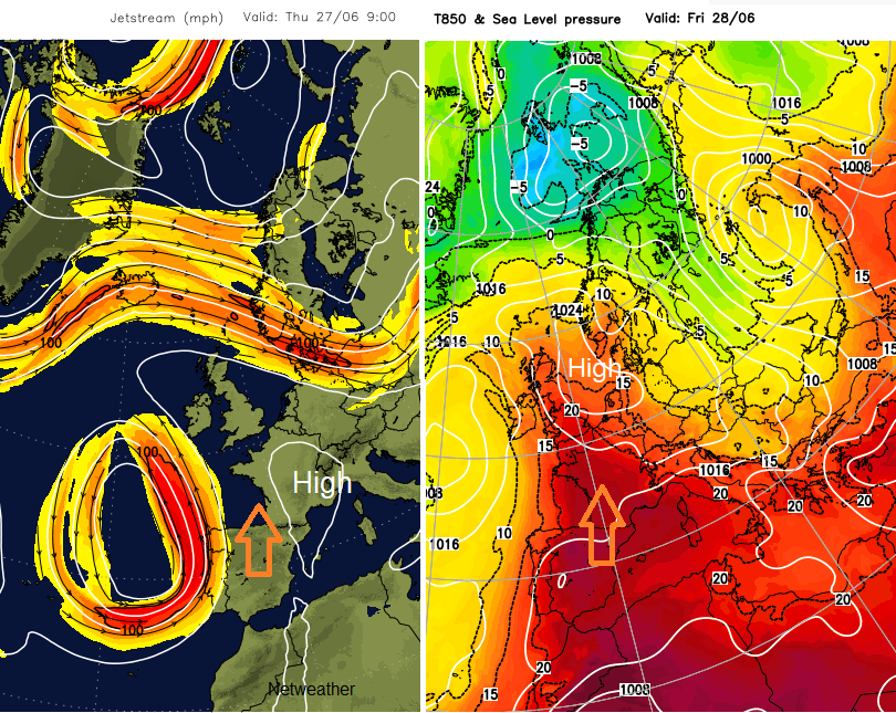
High pressure can bring a lot of fine settled weather in the summer. There can be sunny highs or cloudy ones, everything stagnates as the high just sits still and temperatures rise day on day. High pressure is taking hold of the UK weather for the next few days, but it has ants in its pants and doesn’t stay still. The high wanders from the NW of the UK on Wednesday across the North Sea and then away over central Europe at the weekend.
We will see plenty of fine and dry weather for the end of the working week and some hot and humid air pulled over the UK.
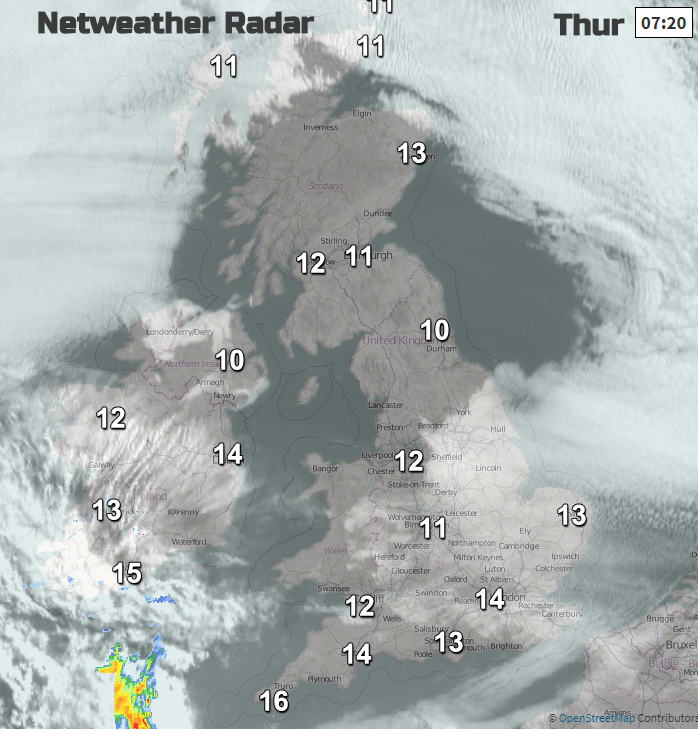
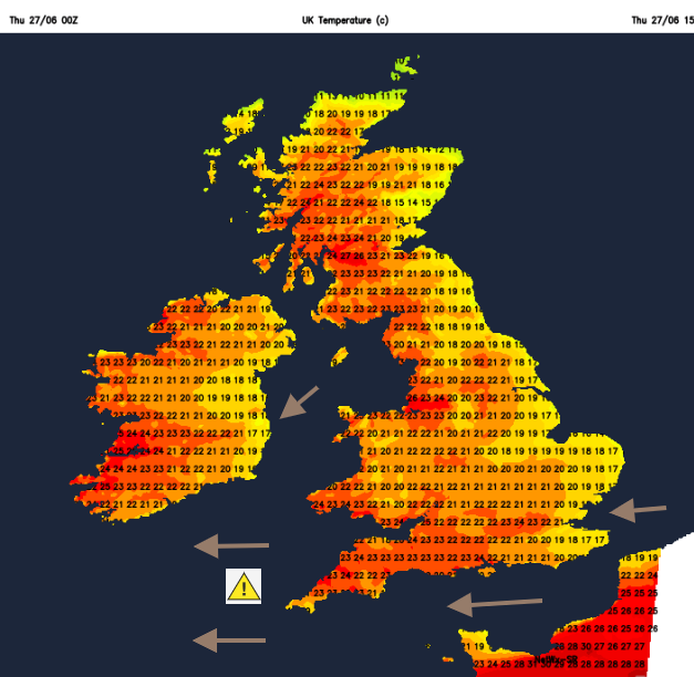
Wednesday saw 24.7 at Porthmadog and just over 24C for Dorset, Devon and the Isle of Wight. Cool air off the North Sea overnight allowed temperatures in North Yorkshire to dip below 3C, at least it was more comfortable for more parts of England in that flow. Low cloud has reached over eastern England into the East Midlands but much more of the UK is sunny today and temperatures will respond as even warmer air pumps in.
Light winds over Scotland will allow the temperature in Glasgow to reach into the 20sC by lunchtime, up to 25C in the afternoon. Very warm for NW England and muggy close air over SW England with temperatures in the mid 20sC.
Again, on Thursday night the cool air moves in from the North Sea with low cloud. Western areas stay a bit warmer but the winds will be fresh and gusty, particularly for Devon, Cornwall and NW Somerset
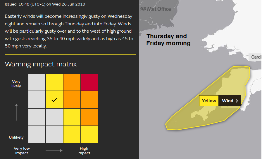
A windy start on Friday for Northern Ireland, Wales, SW England and English Channel coasts with high gusts for western Wales first thing. Gusty too over the Moors of the SW during Friday. The high is over the North Sea and a low pressure is developing out in the Atlantic. This will throw weather fronts over Ireland with the risk of a shower for Co. Fermanagh maybe Cornwall for the end of Friday. One of these, a cold front will be quite key to changes at the weekend.
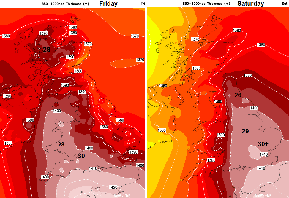
Friday will be the peak of the heat for western Britain and Northern Ireland, Saturday for eastern Britain. 30C is expected around the west country on Friday and low 30sC possible for London or inland SE Britain on Saturday.
What changes?
On Friday the very warm humid air, which has travelled from North Africa, across Spain or France, been heated by more sunshine, reaches SW Britain and pumps up through Scotland. The North Sea follow is still having some effect for the east coast and again Friday night although it looks warm and muggy for SW Britain and Northern Ireland.
The wind veers to the south for Saturday, finally easing off for North Sea coasts and that cold front edges over western Britain. It will bring some showers, hit and miss who gets them but it does shift the hot and humid air away from Ireland and Western Britain further east. With more sunshine, even hotter air Saturday could see temperatures of 34C Hertfordshire, Bedfordshire, London looking like the most prone area. A sultry evening for the eastern half of England with the risk of some sharp showers along the frontal band stretched north-south through Britain moving east on Saturday. Keep an eye on the Netweather Radar at the weekend.
Sunday
A fresher feeling day with a blustery west wind. There will be sunny spells, showers from the west and a more comfortable 23C in London and cooler elsewhere.