High pressure starts to build today, bringing settled conditions, becoming very warm in the west initially, then hot in the east Saturday, before cooling from the west Sunday.
It's been another warm and sticky night across the south, cooler and fresher in the north. The heat and humidity will build through the week.
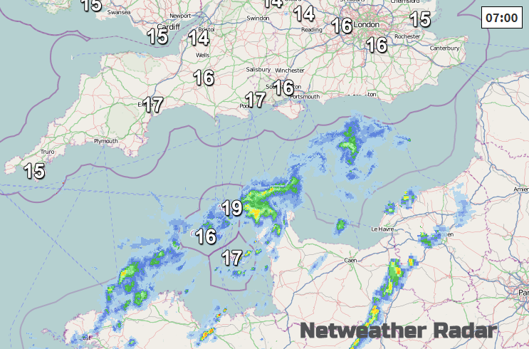
High pressure will build in from the west today, so after a cloudy and murky start - with the odd spot of light rain or drizzle, cloud will tend to thin and break from the northwest, to allow a mostly dry day with increasing sunshine into the afternoon, the lengthiest spells of sunshine across Scotland. A few showers are possible across south Wales and SW England. Temperatures reaching 19-23C generally inland, cooler along coasts.
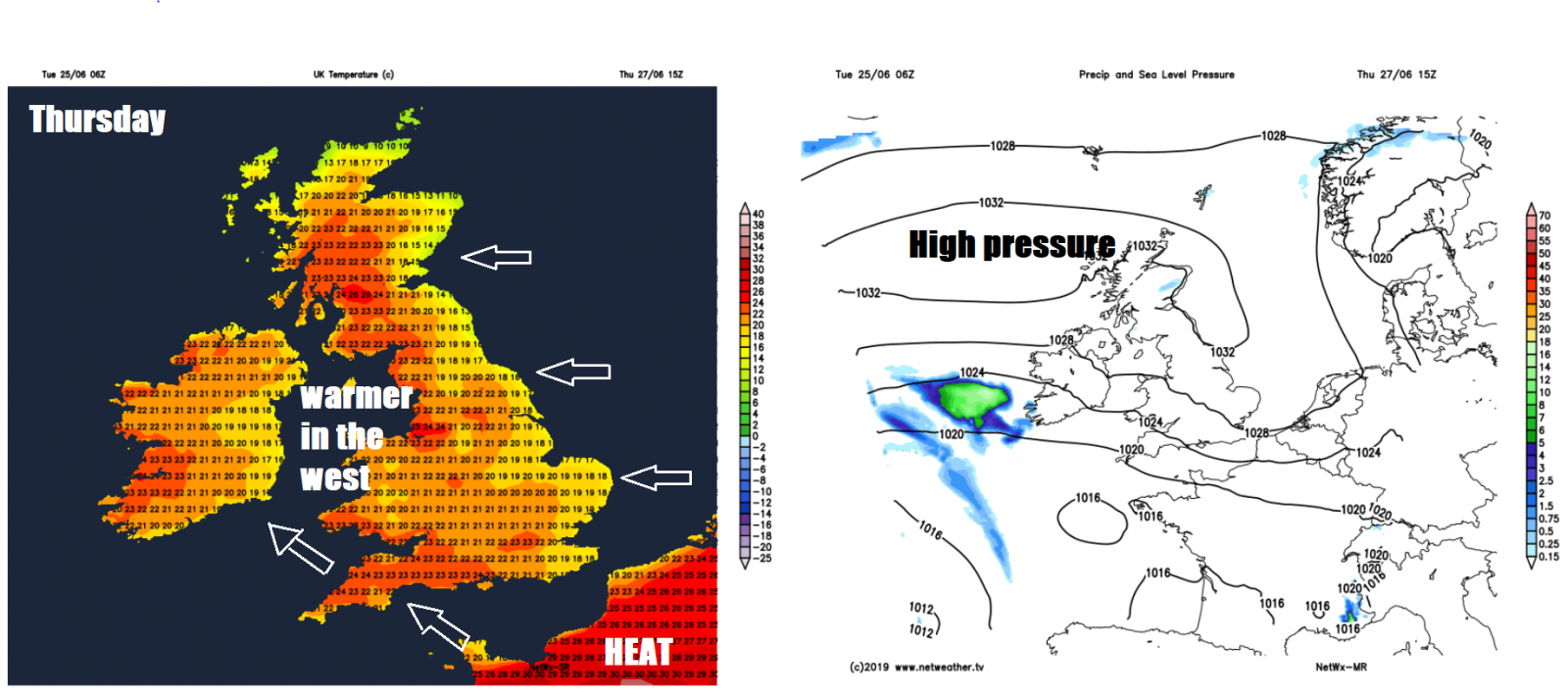
Tomorrow promises a dry and sunny day with light winds under high pressure, some prolonged spells of sunshine, cooler along eastern coasts with an onshore breeze, warmest temperatures likely towards the southwest – where a southeasterly breeze will bringing warmer air out of France. Temperatures generally reaching 21-23C inland, 15-19C along coasts, highest temperature perhaps in Cardiff – which could see 26C and Glasgow may reach 25C.
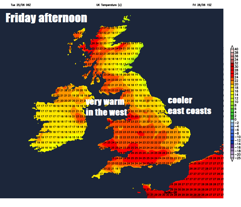
Friday not too dissimilar day to Thursday, high pressure close by over the North Sea in charge so many areas dry, fine and sunny. Highest temperatures across SW Britain where there’ll be a southeasterly breeze of a hot France, so temperatures reaching 29C in Cardiff, 28C in Southampton, 22-26C across elsewhere, though cooler along eastern coasts with onshore breezes where temperatures may stay in the teens. Risk of a few showers across the far west later in the day – particularly across N. Ireland.
Weekend
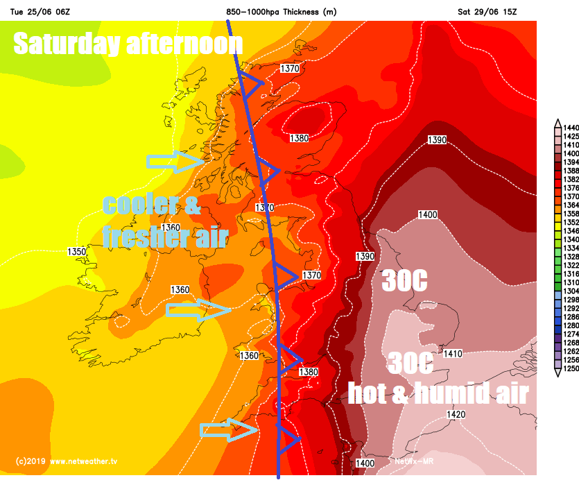
Saturday is looking hot and humid towards the eastern side of England where it will be dry and sunny too, as high pressure sinks into Germany to allow a south or southeasterly flow off a very hot near continent, where temperatures will be in the thirties centigrade. So we could see 30-31C reached across the London area and parts of eastern England in the sunshine. Cooler the further north and west one goes, more in the way of cloud across the west too, as a cold front moves in here bringing some showery, perhaps thundery, rain, but still reaching 25-27C across central areas of England, 21-25C across inland northern and western areas, cooler and fresher towards western coasts to the west of the cold front.
Cold front across the west Saturday tending to weaken as it clears eastwards, though could bring some sharp thundery showers to the north and northeast before it clears and introduces cooler and fresher conditions from the west overnight across all parts for Sunday. A brisk westerly breeze on Sunday for all, meaning a fresher feel, staying mostly dry across much of England and Wales, but Scotland, Northern Ireland and NW England likely seeing some showers with sunny spells in between. Temperatures reaching the mid-to-high teens in the west, warmer across eastern Scotland and eastern England – where we could see temperatures into the low twenties.
Next week, for now, is looking mostly dry for England and Wales, no heat thanks to the flow off the Atlantic, a northwesterly flow early in the week at least, more in the way of cloud and some showers possible for Scotland and N. Ireland initially. High pressure builds in from the west for second half of week, bringing dry and fine weather for most.