We saw another Sudden Stratospheric Warming to begin the New Year, but why, unlike following the February SSW last year, has there been not Beast From The East?
There have been a number of predictions that January and February this year could feature some very cold and snowy weather and not just from the usual tabloid sensationalist stories that purely do it for click bait. The Sudden Stratospheric Warming (SSW) that occurred on the 1st January this year was widely speculated to perhaps emulate the late February 2018 SSW – which was implicated in bringing the early March 2018 Beast From The East.
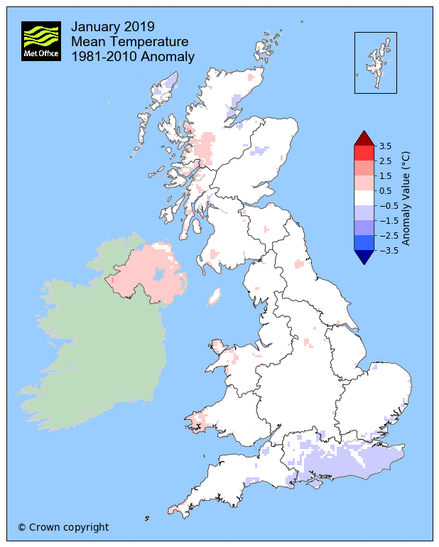
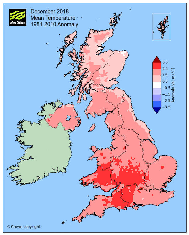
Mean temperatures around average for most of the UK January and above average during December, February likely to come in above average
The SSW in February 2018 brought the Beast From The East, but why not this year following the SSW in the New Year?
However, as I have discussed in previous blogs with regards to SSW events, all events are different and thus have varying impacts and/or speed of impact. Something like one out of three SSWs have no impact on upper patterns across the North Atlantic and Europe to bring a pattern change to bring high latitude blocking which would bring a longer spell of cold weather and snow risks.
However, it’s important to note that not all sudden stratospheric warmings lead to colder-than-normal conditions over the UK and there are other global weather factors that result in blocked weather patterns and possible colder weather for us. These include El Niño and the Madden-Julian Oscillation that were well signalled in our 3-month outlook as early as the end of November.
Met Office
The SSW at the start of the year looks to fall in this category of having little impact, the easterly winds propagating down through the stratosphere following the wind reversal at 10 hPa on 1st January did drip down into the troposphere, but seemingly not strong enough to disrupt the upper patterns this side of the northern hemisphere to bring high latitude blocking.
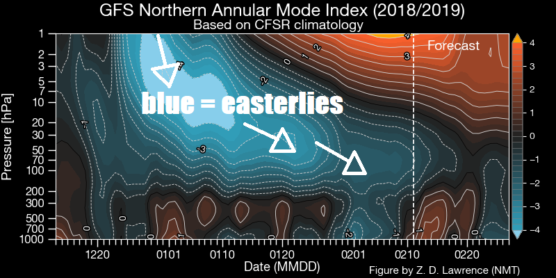
One of the reasons the SSW that may have been unfavourable for high latitude blocking to bring prolonged cold spells for Europe may be the way one of the two ‘daughter’ stratospheric vortices, following the split of the polar vortex, dropped over northern Canada. This displaced vortex was quite deep and strong and was mirrored in the troposphere, where our weather occurs, creating a strong thermal gradient and thus strong jet stream over NE North America and the North Atlantic through January and into early February. This prevented any high latitude blocking occurring over the far north Atlantic or NE Europe, which would have greatly increased the likelihood of prolonged cold weather.
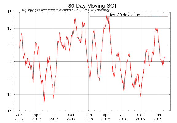
But the unfavourable way the SSW impacted weather patterns is only part of the story of why the winter, so far, has been generally mild with only brief cold spells and marginal snow events – where snow hasn’t hung around for long. There appear to be other atmospheric drivers which have also worked against there being high latitude blocking too, it is not quite clear which of the drivers have been mostly responsible. Being the largest ocean, the Pacific sea surface temperatures, notably in the tropics, can have a big influence on how upper flow patterns behave at high latitudes of the northern hemisphere. The El Nino-Southern Oscillation (ENSO) is the main seasonal driver in this respect. A weak El Nino to neutral ENSO and positive Southern Oscillation Index for much of the winter has perhaps been unfavourable for high latitude blocking.
A positive Southern Oscillation Index this winter has perhaps forced upper patterns unfavourable to produce blocking and prolonged cold weather for Europe
Also, the stratospheric wind profiles above the tropics, of which the Quasi-Biennial Oscillation (QBO) is a measure of, can also influence the Atlantic jet stream in winter. The QBO is westerly this winter and historically a wQBO tends to favour a stronger Atlantic jet stream in winter and thus reduced the occurrence of cold patterns in NW Europe, while an easterly QBO is more favourable. Also, Atlantic sea surface temperature profiles can determine how far north or south sub-tropical high pressure belt develops - which can determine the position of the jet stream over the Atlantic.
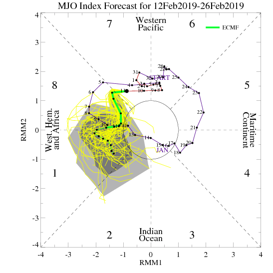
One of the main shorter term atmospheric drivers, which can force pattern changes, is the Madden Julian Oscillation (MJO). Particular phases of this tropical convection cycle, which circumnavigates the globe and can affect weather patterns at mid to high latitudes, are related to particular weather patterns in the northern hemisphere, whether there is influence from an SSW to affect the weather patterns or not. We've seen the MJO cycle head through the more favourable 7-8 phases, which can often induce high latitude blocking, back in early January, before the wave faded. But there was no high latitude blocking to show for it for the rest of the month. The MJO again looks to head slowly through phases 7 and 8, but it remains to be seen if it will change the weather patterns to induce high latitude blocking. There have been suggestions from forecasters on Twitter and weather forums that the SSW may have been actively interfering with the MJO forcing in upper patterns, so may explain why the MJO signal has been muted.
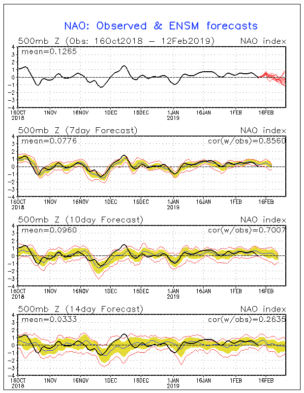
One of the main indices that are forecast by models that give us a general idea that an increased likelihood of colder weather is possible is the North Atlantic Oscillation (NAO). The negative phase of the NAO is when pressure is higher than normal over Iceland and lower than normal over the Azores or Portugal - which is an indication of a southerly tracking jet stream and increased likelihood for cold easterly or northerly winds. NAO went into negative phase following the SSW in February 2018 and so helped the Beast from the East move west across the UK late February and early March. However, since the SSW to start this year, the NAO has been stubbornly positive, as it has through most the winter. The lack of impact on the upper flow patterns from the SSW this year to flip the pattern from a positive to a negative NAO, unlike following last years SSW, unfavorable forcing on upper patterns from the Pacific and also sub-tropical high pressure belt of the Atlantic failing to be suppressed and allowing a southerly tracking jet and negative NAO are possibly some of the factors that have kept this winter milder than average. Though of course, we have seen colder spells as is possible in a generally mild winter.
This winter, the North Atlantic Oscillation has been mostly in positive territory, which is associated with generally above average temperatures for UK
So, with the above in mind, it really exposes the limitations of using MJO forecasts and stratosphere forecasts along with other drivers to predict very far ahead, beyond 10-15 days at least, with any confidence. As this winter has shown, there are just too many conflicting signals. The tropical oscillations, stratosphere state along with others are still a valid predictive tool but must be used with caution.
So, where does that leave us for the rest of the winter? Well, the models suggest low confidence in any major pattern change that will bring high latitude blocking that will bring colder conditions conducive for snow widely away from higher ground. In fact, this week could turn rather mild on Thursday and Friday, in a long-fetch southwesterly flow from the Azores, lifting temperatures widely in the low teens, perhaps 15C to the lee of high ground, such as NE Wales/Cheshire Plain to the lee of mountains in north Wales, also parts of Devon, west Wales and the Moray Firth in Scotland to lee of high ground.
There is still a possibility IF the MJO can get a move on through 8-1, given the lag effects of around 10 days or so, there is potential for the final few days of February and beginning of March for a pattern change that may promote high latitude blocking, if the MJO wave impacts the upper patterns without interference from other drivers. But there is also no guarantee that the blocking will develop in a favourable position either.
We have 3 weeks left of February and most of March to still get some snow, but it looks like the next few weeks would be hard pushed to see any for most. It will take a pretty brutal deep cold blast to bring ice days (daytime temperature maxes of 0C or below), such as we saw in early March last year, to bring lying snow for long in March.