HIgh pressure over France will bring fair conditions this week with some early fog and mist. Rain and blustery winds will cross NW Britain and Northern Ireland tomorrow.
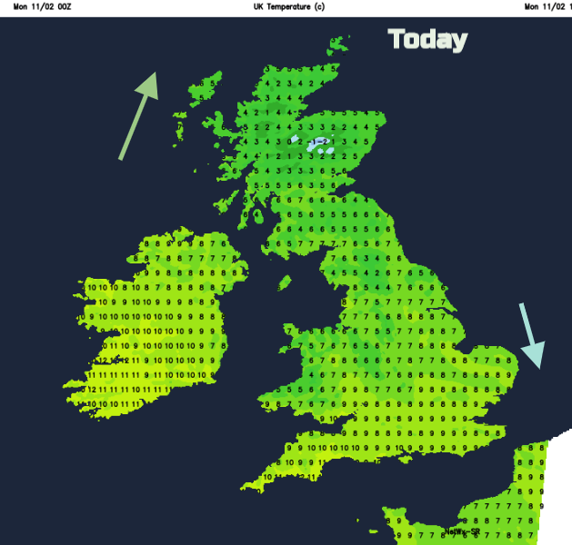
With clear spells and a northerly wind overnight, it a colder start this morning from parts of the UK than of late. There is a warning for Ice in northern Scotland from the UK Met Office, but Monday will be a fine bright day as pressure builds in from the west.
There is a line of cloud and showery outbreaks over northern England edging southwards and a feed of cloud and showers into north Wales. Both of these areas fade, and the weather will improve today with light winds. Temperatures will be around 7 or 8C with 10C in London and the SW and only 4 or 5 for northern Scotland.
Later a warm front heads towards NW Scotland bringing cloud rain and a freshening southerly wind.
Tonight, it stays mild over southeast England with hardly any breeze. The cloud in the NW keeps the temperatures up for Northern Ireland, Wales and much of Scotland. Northern England into the Midlands could see a touch of frost, as may inland Wales and eastern Scotland earlier in the night. Fog is also expected for southern Britain under the still conditions.
Tuesday
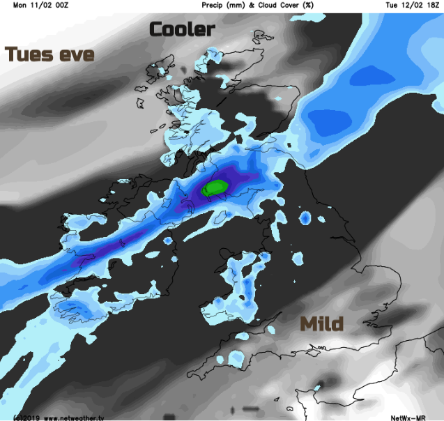
A series of weak weather fronts bring more cloud in from the west tomorrow but overall it is a fair day. There will be a south-westerly wind, light in the SE, fresh further north with gales for the Western Isles first thing. As a cold front arrives in the NW there will be outbreaks of rain for Northern Ireland, later morning and over lunchtime moving eastwards and rain for western Scotland in the morning, over Strathclyde by lunchtime too. It will be a much milder day with temperatures of 9 to 11C, even 12 or 13C to the lee of high ground. The frontal band fades over eastern Northern Ireland and southern Scotland on Tuesday evening with cooler conditions into northern Scotland. Most places have a settled mild night with high pressure centred over France. Fog and mist will be a feature of this week’s weather.
A weak frontal band waves south, bringing grey skies and dampness then pushes well away to the north mid-week. Milder air flows up from the south with little change until Friday. It will often be windy for western Ireland and NW Scotland with the lightest winds still over SE Britain, closer to the centre of the high.
Half term
After more settled weather for the working week, there looks to be a shift during Friday with more unsettled, blustery weather across the UK next weekend after a frontal band of rain passes through. We’ll watch this week to see if the high pressure can hold on a bit longer. If you have half term this week, it’s not too bad but it does look like the start of next week will be more unsettled with blustery winds and outbreaks of rain.