Despite a lot of uncertainty late last week, the beast from the east is not coming now, instead a polar northwesterly flow will often prevail, so cold with risk of snow for some and ice.
In my last blog, last week, I talked about the potential for bitterly cold easterly or northeasterly winds to develop later this week. This potential will not occur now and not likely to in the next week at least.
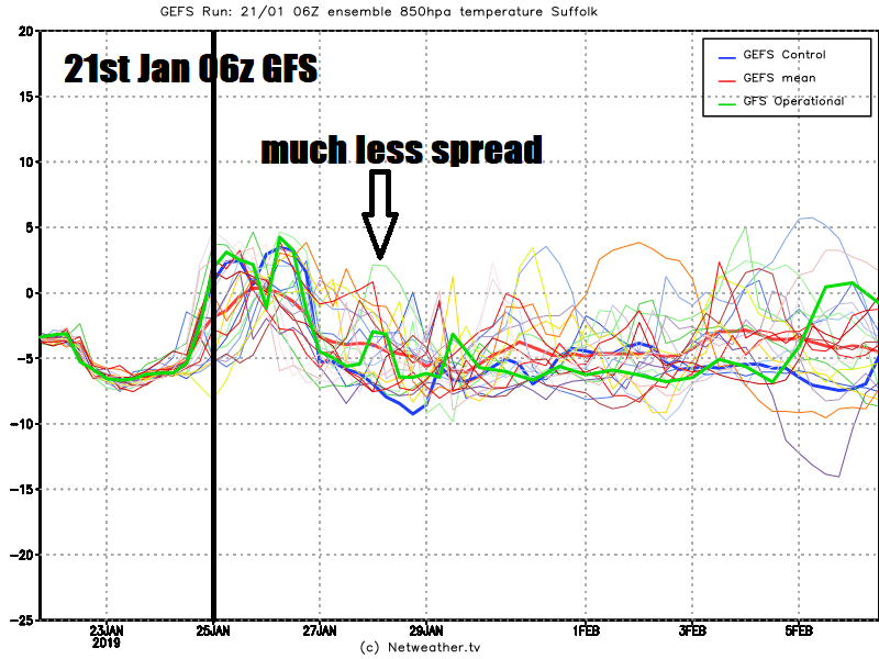
There was a great deal of model uncertainty last week with regards to whether it would turn very cold, cold or just mild, as highlighted by the spread of the ensembles members last week.
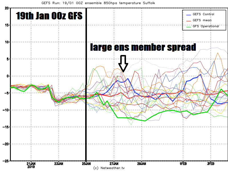
The reason for the uncertainty probably down to a combination of factors, not least a winter storm over eastern USA at the weekend causing some short-scale uncertainty with regards to its impacts on the flow downstream over the Atlantic – which in turn had ramifications to whether high pressure ridge over the Atlantic would build northeast to join an arctic high off eastern Greenland – which equally had uncertainty attached with its movement. Alas, in the end, the flow energy over the Azores high that was expected to ridge northeast was too much, so upper flow rounding the Azores high and heading southeast into a persistent European upper trough will be too flat and strong to allow enough amplification of the flow to allow pressure to rise to the north and northeast to allow an easterly or northeasterly flow.
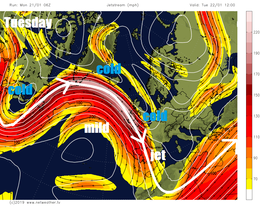
However, now there is reasonable model consistency now on the outlook ahead. A persistent European upper long-wave trough will continue to be a feature in the days ahead, to the west an Azores high amplifying north at times. Upstream of the Atlantic another deep trough over eastern North America expanding south at times in tandem with the Azores high ridging north (imagine a set of scales).
The UK and Ireland will move into an increasingly unsettled pattern over the coming days, predominantly in a polar northwesterly flow sandwiched between the Azores high displaced north at times to the west and the persistent Euro trough, but with some occasional brief milder interludes ahead of low pressure systems dropping southeast from Iceland areas. Temperatures will fluctuate between mild and cold as a result, but with the UK more often than not cold on the cold side of the jet stream ploughing southeast into Europe, the UK north and east of the jet in these colder periods.
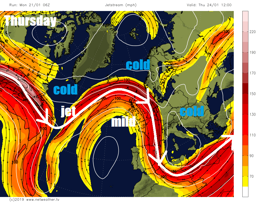
Because it will be unsettled with low pressure systems passing close by and wedges of cold polar air between systems, there will be a risk of snow at times. Frontal systems moving southeast will often have ‘mild sectors’ ahead of them, so rain most likely for many along these fronts, but cold polar undercutting the rear of the fronts bringing snow but mainly confined to higher ground and perhaps temporarily lower levels in the north. However, once in the cold polar flows, there is potential for wintry showers to bring snow almost anywhere in the UK, settling most likely over high ground at all times or temporarily at lower levels at night time. Widespread frosts are likely in clear spells in the cold polar northwesterly, sometimes veering northerly flows, leading to a risk of ice where showers are falling.
Tuesday to Wednesday – COLD
Active occluding cold front will sweep southeast across the UK tonight, mainly a band of rain but some back edge hill snow possible for northern and western areas and sleet for lower levels. Risk of ice developing on wet surfaces as colder polar air and clearer skies follow rain/hill snow band.
Tuesday a cold day with a brisk cold northwesterly wind which will blow in wintry showers, around western coastal areas in the north, but a trough moving east across England and Wales could bring a more organised area of wintry showers across many areas, with snow falling in places, but unlikely to settle away from high ground. Risk of ice forming on wet surfaces overnight into Wednesday following showers as skies clear.
Wednesday looking cold but mostly dry and bright as ridge of high pressure builds, though some wintry showers around northern and eastern coasts. Temperatures generally in low single figures.
Thursday and Friday – MILDER
Low pressure passing Iceland will drag in milder air from the west off the Atlantic, so less cold with temperatures perhaps recovering to 9-10C in the south. More in the way of cloud too on Thursday, bringing patchy rain or drizzle. England and Wales drier Friday, but rain returning from the northwest across Scotland, perhaps heavy in the northwest.
Weekend – TURNING COLDER
Mild start in the south on Saturday, but cold front with band of rain moving south out of Scotland Friday night will continue south Saturday morning, clearing south coast in the afternoon with colder polar air returning from the north and northwest for the rest of the weekend, with it wintry showers in the north and a risk of widespread frost where skies clear.
Next week – STAYING GENERALLY COLD
Staying on the cold side next week but unsettled, as further lows developing off southern Greenland drop southeast towards northern Europe, bringing predominantly a cold polar northwesterly flow feeding cold air off a cold Greenland ice sheet, albeit moderated over the Atlantic warmer waters. So bands of rain and hill snow moving southeast, with wintry showers in between, a continued risk of snow in places, mainly over hills, but to lower levels at times too, snow settling mainly over higher ground, but perhaps lower levels to at night time. Day time temperatures probably a little too high in the south for any overnight snow to stick around. Some snow could possibly be disruptive in the north, more especially over higher routes.
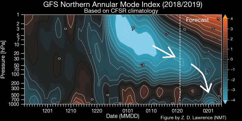
Looking further ahead, I’ve previously discussed the potential impacts of the wind reversal to easterlies working down through the stratosphere, following the Sudden Stratospheric Warming to start the month, and impacting the troposphere circulations at high latitudes, i.e. increased high latitude blocking. Well these easterlies have yet to do so, but there is an indication this may occur to end this month, so we could see a pattern change featuring high latitude blocking in February, increasing risk of much colder northerly or easterly flows.