Deep low passing Shetland today will bring severe gales to northern Scotland. Colder & brighter Tuesday & Wednesday, then milder and cloudier towards end of week.
High pressure has been in control of our weather since the beginning of the New Year, bringing quiet and settled weather – but this is set to change across the north today, as a deep area of low pressure passing close to Shetland today brings wet and windy weather, with severe gales to northern Scotland. Following in wake of today’s deep low to the north moving on towards the Baltic Sea will be a colder but dry northerly flow on Tuesday, bringing chillier weather for a few days. Then high pressure builds back in the from the west by Wednesday, so the rest of the week will be mostly dry and milder too, but rather cloudy.
For now, a cloudy, windy and in places wet morning across Scotland, most of the rain across northern and western areas, heavy and persistent across western hills. Winds will strengthen across northern Scotland through the day, already gusts of 40-50mph in the far northwest, but gusts increasing with 65-80mph possible, so damaging gusts with power and travel disruption possible across northern Scotland and Northern Isles. Some brightness or sunny spells developing by the afternoon, with drier conditions across the south, but showers packing in across northern and northwestern Scotland and remaining very windy here, with severe gales.
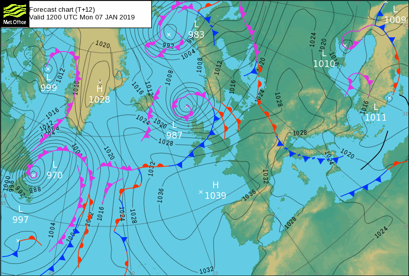
Cloudy and breezy with outbreaks of rain pushing southeast across N. Ireland and northern England through the morning, but to the south across the rest of England and Wales it’s dry though rather cloudy and frost-free. Most areas staying cloudy and breezy through the afternoon, with patchy light rain or drizzle spreading further south across England and Wales while drying up from the north, though some brightness could develop across the northwest before nightfall.
A mild day, temperatures reaching 9-10C across England and Wales, 7-9C across Scotland and N. Ireland, though temperature falling across northern Scotland as colder air moves in from the north.
Remaining very windy with severe gales across northern Scotland through this evening and into early Tuesday morning, with plenty of showers packing in at first, which will turn wintry over high ground, before easing. A windier night than recently further south, but turning mostly dry with clearing skies moving south following a band of cloud and patchy drizzle across the south ahead of cold front bringing the clearer conditions from the north. Under the clearing skies and colder polar air spreading south, temperatures dropping into low single figures, perhaps bringing patchy frost across the north.
So, a bright but chilly start on Tuesday for many, a brisk northerly wind in the morning towards the east, touching gale force down along eastern coasts for a time in the morning, which will bringing some big waves along North Sea coasts, but winds easing through the day, lightest winds in the west. For many it will be a sunny and dry day, a few blustery showers clipping North Sea coasts though. A little colder than of later, with temperatures back into single figures, reaching 7-9C generally, perhaps 10C in the far west.
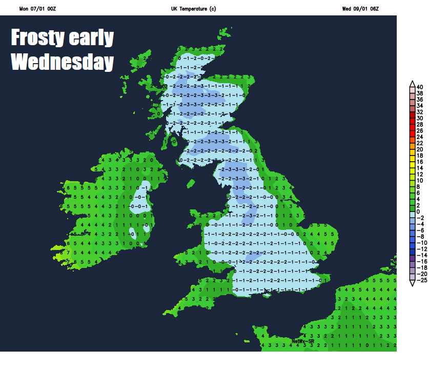
Clear skies Tuesday night, away from eastern coastal areas of England and the far west - where there’ll be more in the way of cloud, will lead to a widespread frost, with lowest temperatures below freezing across Scotland. So, a cold and, for some, frosty start to Wednesday, with day itself dry and sunny but chilly for most. More in the way of cloud towards eastern England, also NW Scotland and the island of Ireland where it will be thick enough for some patchy rain later. Temperatures generally reaching 4-7C at best and likely the coldest day this week, but turning milder in the far west – where it will reach 8-9C.
After a chilly mid-week, milder air off the Atlantic towards end of week, as flow comes around the top of high pressure close by
A sunny start with perhaps a touch of frost across the Midlands, East Anglia and southern England on Thursday, otherwise cloudier skies and milder air spilling southeast off the Atlantic across many areas through the morning and into the afternoon, thick enough for some patchy light rain or drizzle over western hills, but for most it will stay dry as high pressure builds. Temperatures reaching 6-8C across central, southern and eastern England, a milder 9-10C across the north and west. Similar weather and temperature-wise for Friday too, high pressure close to the southwest means a mild but cloudy flow off the Atlantic over the top of the high across the UK and Ireland, best of any brightness likely across southern and eastern areas, cloud thick enough across the northwest for some patchy rain.