More rain today from the west with blustery winds but after more heavy rain tonight there will be gales and gusty winds for Friday. This could affect end of week travel.
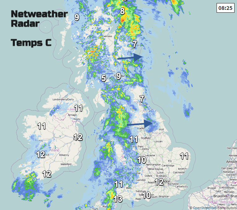
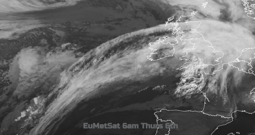
By Sunday we will have seen three low pressure systems moving across the UK from the Atlantic, bringing rain and blustery winds. One today, you can see the rain on the radar picture over the Irish Sea. One for Friday which looks the most lively and another during Saturday before high pressure steps in and says enough is enough!
After that the weather settles down and becomes calmer and drier til at least midweek.
Today's rain will move eastwards but NE England looks dry, sheltered by the Pennines. Western Britain sees the most rain, especially over the hills but Northern Ireland will soon become drier as the band moves away eastwards with just one or two light showers left. It is much milder this morning in Scotland after yesterdays frost and ice. It will be wet for a time before the occluding front moves away to the NE, leaving behind a scattering of showers and brighter skies.
It will be a wet morning for Wales and NW England as the rain just continues. Eastern England will see some bright spells to start the day, it is cooler here around 5C, but the cloud will increase, and it will turn damp and grey for a time. Temperatures will be 11 to 13C widely across the UK with a brisk SW wind maybe 14 or 15 to the lee of hills.
For a time, this evening Northern Ireland and Scotland will have clear skies and temperatures will dip away even a slight frost for Grampian. Elsewhere it stays mild as the next system heads in. The winds pick up, cloud increases and more rain heads in. Even by Thursday teatime, the trailing weather fronts will be waving back into SW Britain bringing more rain and this then gathers itself for Thursday night as a deepening low pressure comes closer.
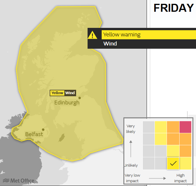
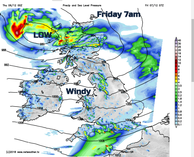
There will be plenty of rain and the Met Office have a yellow wind warning for northern Britain and Northern Ireland. A lot of the heavy rain will be before dawn. The low pressure centre is forecast to run to the west of Northern Ireland and the Western Isles, with the weather fronts bowing across the UK. So, rain across Scotland out over eastern England and curling back over southern England
The rain bands push over SE England in the morning and northern Scotland, with hefty showers tucking in behind. In the colder air, there could be sleety bits over the hills of western Britain. As the low moves over northern Scotland, the occlusion moves even more rain into the west coast, so totals will be highest here. There will be sunny spells, but it will feel colder after lunch.
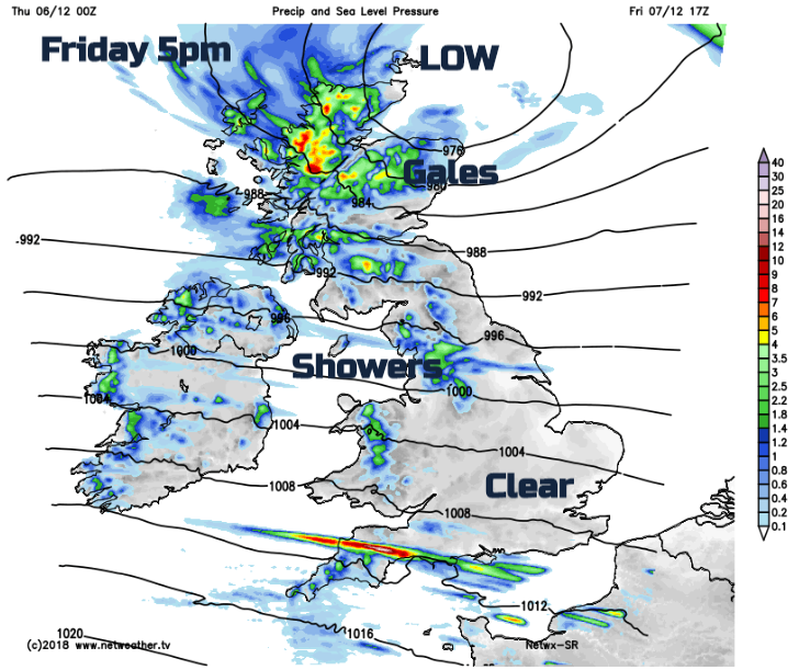
You’ll notice on the wind warning that the matrix shows the possibility of high impacts but that is still considered not to be the most likely forecast solution. This will be updated this morning by the Met Office. This low will bring strong to gale force winds with severe gales for Scotland. The exact location and timings still needs fine tuning.
Friday am rush hour: Fresh to strong SW winds with coastal gust over 50mph for southern England. SW to W gales Irish Sea and North Channel with gusts over 60mph and severe gales for west coast Scotland. Concerns for the Hebrides Friday morning with gusts over 70mph. By late morning windy everywhere in a westerly. Highest gusts still over central/northern Scotland by lunchtime. By Friday pm rush hour strongest winds look to be over eastern Scotland with a wild spell of weather spreading over more of the UK during Friday evening.
Disruption to travel seems likely on Friday, possible interruptions to ferry and rail services and power supplies. Conditions on the roads will be tricky with frequent high gusts and ongoing strong winds.
It stays blustery overnight except for Scotland where it turns colder. There will be brighter weather for a time on Saturday morning with the next low bringing rain over Ireland in the afternoon and across Britain Saturday evening. This could bring a bit of snow over northern hills as the rain band hits the colder air. The winds strengthen in the south during Saturday evening and night. Another wind warning may appear today for this.
The weather will calm down for next week, but for now keep an eye on the Flood alerts and warnings if you are in western Britain and watch out for the high winds tomorrow.