
Cold and raw easterly wind stronger today, bringing showers across many areas, turning wintry overnight. Showers confined to north and west tomorrow, becoming drier towards end of week.

The easterly wind will be stronger today, which will mean it will feel even colder thanks to the wind chill, with showers or longer spells of rain spreading west across many areas. The showers will turn wintry in nature tonight, especially over hills, with sleet and snow possible. Wednesday sees showers confined to Scotland and Northern Ireland, while England and Wales become drier and sunnier. Generally becoming less cold, drier and sunnier on Thursday and Friday, as the wind veers from easterly to southeasterly, though a few showers are still possible for some.
Tuesday’s started with showers from the word go across eastern areas of Scotland and England, with shelter from the wind and clearer skies across western areas you may have started the day with a touch of frost and all in all it’s a chilly start to the day.
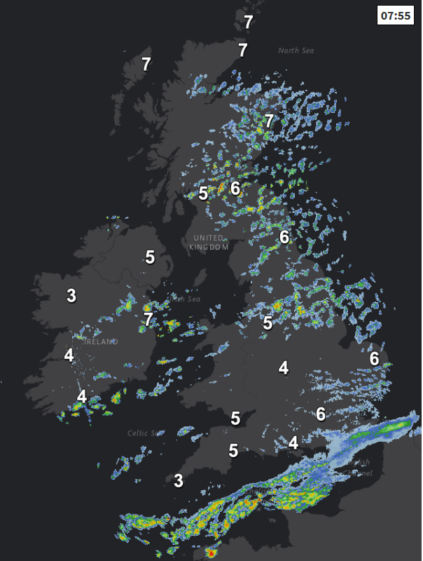
Make the most of the sunny spells this morning, the best of which will be in the west, as generally across England and Wales cloud will blow in from the east with a rash of showers spreading west on the strong easterly wind, heaviest and most frequent across northern and eastern England, fewer across Wales and SW England. Again, the eastern side of Scotland seeing plenty of showers, but western Scotland and Northern Ireland fewer showers and more in the way of sunny spells.
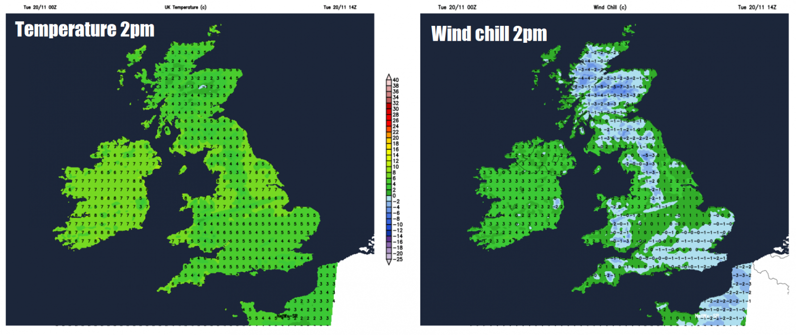
Quite a strong and gusty easterly wind, notably so along North Sea coasts - where we could see gusts of 40-50mph, bringing quite a wind chill. Temperatures in single figures for all, lowest across SE England and East Anglia where highs of 5-6C at best likely, 6-9C generally elsewhere. Add on the wind chill and it’ll feel more like 0-2C in southeast Britain, 3-5C elsewhere.
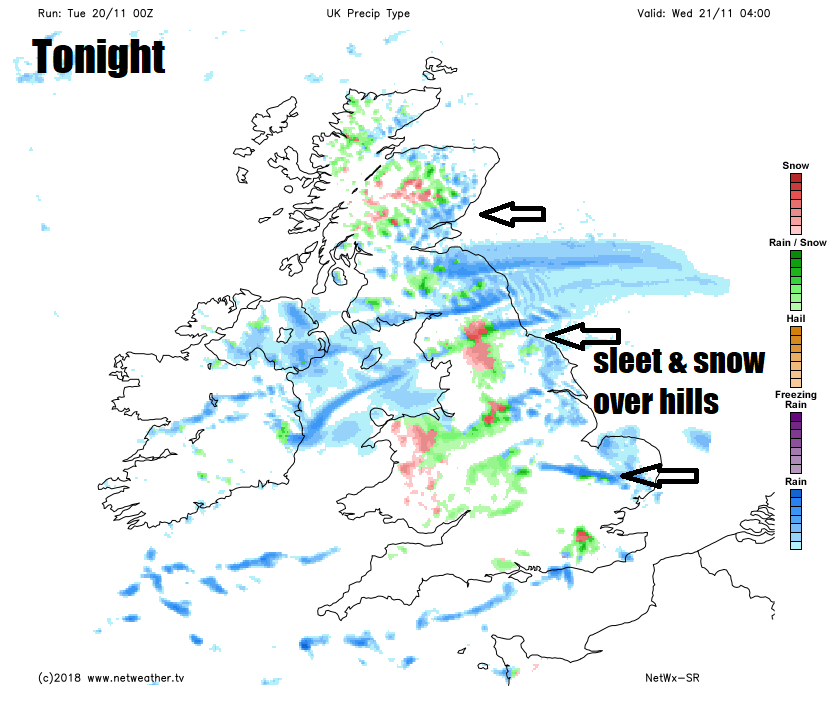
The showers just keep coming as we head through this evening and overnight, merging to give some longer spells of rain across England, Wales and eastern Scotland, with some sleet and snow falling over higher ground, settling over higher parts of the Pennines, North York Moors, Southern Uplands and Highlands for example, while some wintriness could be mixed in at lower levels too. So all-in-all, a cold, wet and miserable night to be out and about.
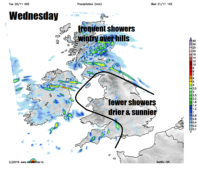
Then on Wednesday, the showers, wintry over the hills, will become mostly confined to Scotland and Northern Ireland through the day, while easing to sunnier skies and drier conditions from the east across England and Wales, though showers may continue across SW England and Wales. The wind easing too across the south, so feeling a little less cold than today. Temperatures reaching 6-9C generally, perhaps 10C in the far northwest. Risk of overnight frost developing widely as skies become mostly clear away from the far north and coastal areas where showers may continue.
As we head towards the end of the week the pressure pattern will be dominated by low pressure to the southwest and high pressure to the northeast, so we lose the cold easterly wind to a less cold and less strong southeasterly instead. So Thursday is looking mainly dry and bright or sunny and feeling less cold, though there could still be some showers around eastern and western coasts. Friday mostly dry and sunny again, though some showers are possible for Scotland and also SW England along with parts of Wales.


