Wet start in the north and windy for many today. #StormAli threatens severe gales across the north on Wednesday then generally unsettled rest of the week.
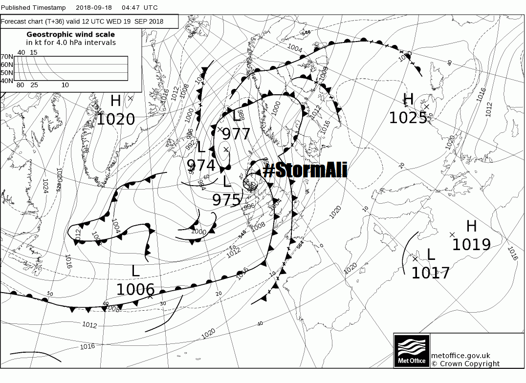
A strong Atlantic jet stream across the UK for the rest of the week and the weekend will bring a succession of low pressure systems, bringing spells of wet and windy weather over the coming days, with a risk of disruption from gales in places. The first of these vigorous low pressure systems contains the remnants of ex-Hurricane Helene and will pass across northern Britain this morning, bringing a wet start here, while bringing strong winds across England and Wales. Wednesday sees another depression, recently named #StormAli, even deeper than today’s, bringing stronger winds and heavy rain to the north and west. It remains windy for the rest of the week, with a slow-moving area of rain moving in across England and Wales on Thursday slowly clearing south by Friday, blustery showers across the north and west.
A strong jet stream will bring a succesion of low pressure systems, some deep, across the UK over the coming days
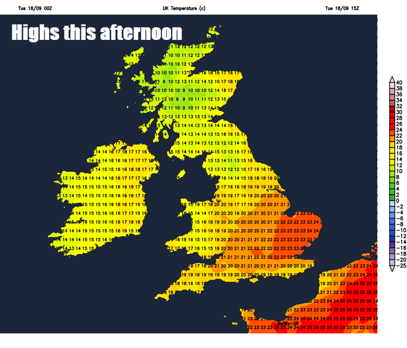
For now, a rather windy start to the day across England and Wales, with gales around western and southern coastal areas, north Wales has seen gusts of 55-65mph. It is also rather warm, with temperatures widely 15-18C at 6am, even as high as 20C in central London. For Scotland and northern England it’s a wet start, with heavy outbreaks of rain for the morning commute, generally cloudy elsewhere further south, with some showery bits of rain across western areas and patchy drizzle elsewhere.
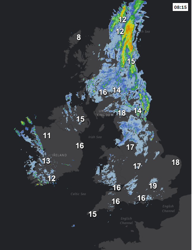
Continuing windy for the rest of the day across England and Wales, the stronger winds arriving across Scotland too, gusts of 40-50 mph possible widely across western areas, perhaps 50-60mph around exposed coasts and hills. The heavy rain will clear northern areas through the morning through replaced by sunny spells and scattered showers across western areas. Eastern areas largely dry and becoming sunny and it’ll be warmest in the east too, with temperatures this afternoon reaching 22-24C across eastern England. Across northern and western areas temperatures reaching 17-19C.
A band of heavy showers along a cold front will spread eastwards across many areas later in the evening and overnight, perhaps with the odd rumble of thunder and accompanied by gale force gusts in places. Southeast England likely staying dry though. Clear spells following across northern and western areas later in the night, before gales and heavy rain arrive across Ireland, N. Ireland and western Scotland by dawn. Another mild night with temperatures staying in double figures, perhaps mid-teens in the south.
Then the second depression of the week arrives close to the northwest on tomorrow, Met Office & Met Eireann have jointly named it #StormAli, bringing stronger winds than today, gusts of 50-60mph developing widely through morning across Scotland, northern England, north Wales, N. Ireland and Ireland, perhaps 60-70 mph around western coasts, maybe more with exposure across western Scotland. The strength of these gusts combined with trees and leaf could bring some disruption in places, the Met Office have a yellow weather warning issued.
Storm Ali wind gusts on Wednesday (GFS model)
The strong winds across these areas also accompanied a spell of heavy rain moving through late morning and early afternoon, followed by sunny spells and blustery showers across the northwest by late afternoon. Sunny spells and perhaps some showery rain moving through further south across England and Wales.
Continuing unsettled and windy on Thursday, a developing low along a frontal wave riding in from the west will bring outbreaks of rain, locally heavy, across Wales, SW England, The Midlands and northern England through the day, sunshine and blustery showers across Scotland, southeast England perhaps staying dry and sunny until the evening – when rain arrives from the west. Temperatures generally in the low to mid-teens, but towards southeast England and East Anglia perhaps reaching the low twenties Celsius.
Rain clearing the far southeast first thing on Friday, then England and Wales mostly dry and bright or sunny bar the odd shower in the west. Sunshine and showers for Scotland. Still windy for most, cooler for all, with temperatures in the teens.
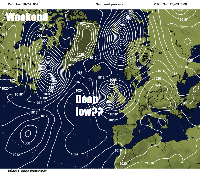
After perhaps a dry and bright morning, the weather looks to go downhill through Saturday, as another perhaps deep low moves in off the Atlantic by Sunday, bringing wet and windy weather across all parts by the evening and overnight into Sunday. Widespread gales or severe gales are currently indicated Saturday night and through Sunday, bringing a risk of disruption, rain clearing eastwards Sunday.