
Sunshine & showers today, then changeable over the Bank Holiday Weekend, featuring a washout Sunday.

It will feel noticeably cooler and fresher across all parts today, thanks to a brisk westerly wind and although it will be sunny, most areas will see some heavy showers. The Bank Holiday Weekend will remain on the cool and changeable side with temperatures below average for the time of year. Nights will be on the chilly side, with a risk of frost across the north. Saturday will see sunshine and some showers, while on Sunday a spell of wet and windy weather will sweep east across all parts. Bank Holiday Monday, though not in Scotland, will be mainly dry and a little warmer, though westerly breeze may bring a few showers in the west.
For now, many eastern areas are off to a dry and sunny but cool start, while in the west there is more in the way of cloud producing some showers – particularly frequent and heavy across western Scotland, NW England and the northern coast of N. Ireland.
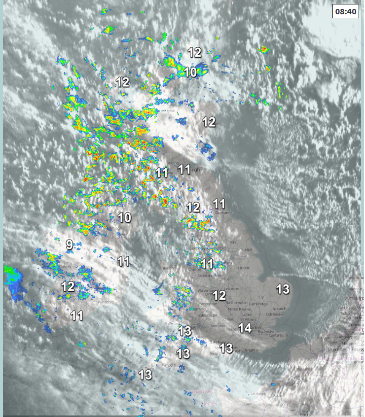
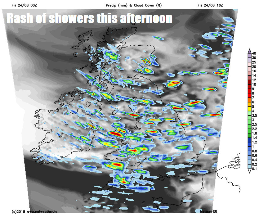
As we go through the day, the showers in the west will become more widespread across Britain, driven through by a brisk westerly wind, the showers locally heavy and increasingly accompanied by hail and thunder as we head into the afternoon.
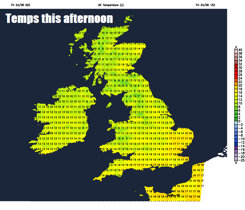
The strong westerly wind, perhaps gusting to 30-40mph in the west, and showers passing through will mean temperatures will be down on recent days, particularly in the south, reaching 16-19C at best in the south, 14-15C in the north.
Perhaps a more organised band of heavy showers and thunderstorms moving southeast across Wales and southern England for a time this evening, before showers become confined to northwestern areas while elsewhere becoming dry with clear spells and turning chilly, with temperatures falling into low single figures in rural areas, perhaps a local frost developing in northern areas.
Saturday should be a better day with fewer showers and more in the way of sunshine, as low pressure moves away to the east and a brief ridge of high pressure builds in across the west. Most of the showers developing in the afternoon across eastern and southeastern areas. The northwesterly breeze not as strong as today, so a little warmer, reaching 17-20C across England and Wales, 14-17C across Scotland and Northern Ireland.
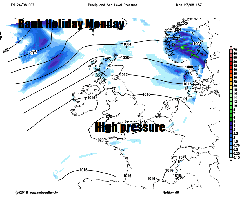
An area of low pressure will approach northern Britain on Sunday which, after perhaps a bright start in the east, will spread outbreaks of rain and gusty winds eastwards across all parts during the day, followed by brighter conditions and blustery showers across the far west in the evening. Temperatures reaching 13-16C in the north, 16-18C in the south, so disappointingly cool for the time of year.
Then into Bank Holiday Monday, it’s looking the better day of the long weekend, thanks to a ridge of high pressure building in from the south. So most places will be dry, sunny and warmer, though the westerly breeze may bring a few showers in the west with thicker cloud and some rain arriving across NW Scotland by evening. Temperatures reaching 16-18C in the north and west, perhaps 20-22C across southern and eastern areas of England.
Continuing changeable for the rest of the week. Tuesday’s looking mostly dry – though perhaps some rain arriving in the west later in the day. Outbreaks of rain affecting parts of England and Wales, perhaps heavy and thundery towards southern and eastern areas, along with NW Scotland on Wednesday. High pressure building in for the rest of the week should mean dry and sunny weather for England and Wales, dry for Scotland until cloud and rain arrives on Friday.


