


A humid flow off the Atlantic this weekend, bring a lot of cloud and also an ex-tropical storm - which will bring a spell of heavy rain to the north. Warm where the sun comes out in the south.
This weekend our weather will be coming in off the Atlantic, so unfortunately it will be on the cloudy side, with the addition of an ex-tropical storm named Ernesto in the mix – which will bring wet and windy weather tonight into Sunday morning, the rain mostly across northern Britain. It will feel humid across the south though, as we draw in tropical air ahead of ex-Ernesto, and if the sun comes out across the south – it will feel rather warm. The changeable conditions off the Atlantic will continue next week, often breezy, but most of the rain across the north just briefly affecting the south perhaps on Thursday, where the sun comes out it will feel warm in the south.
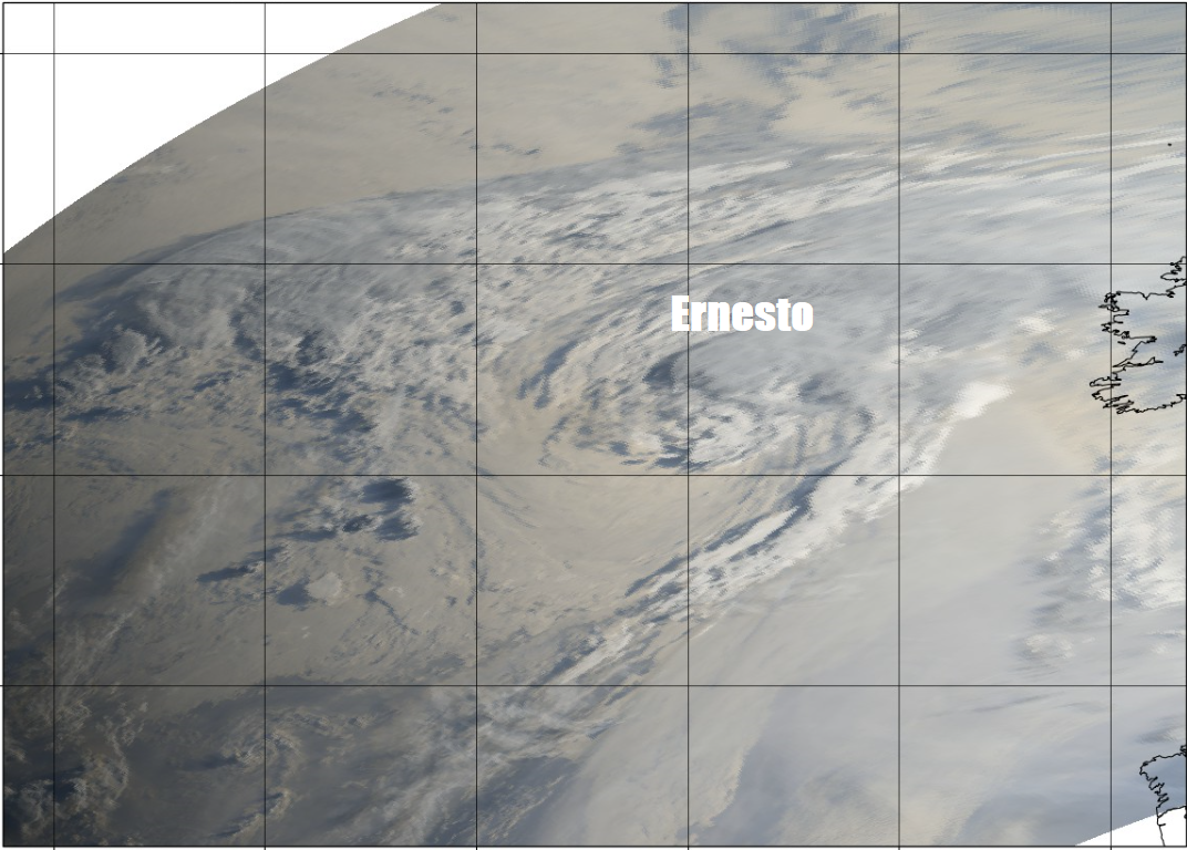
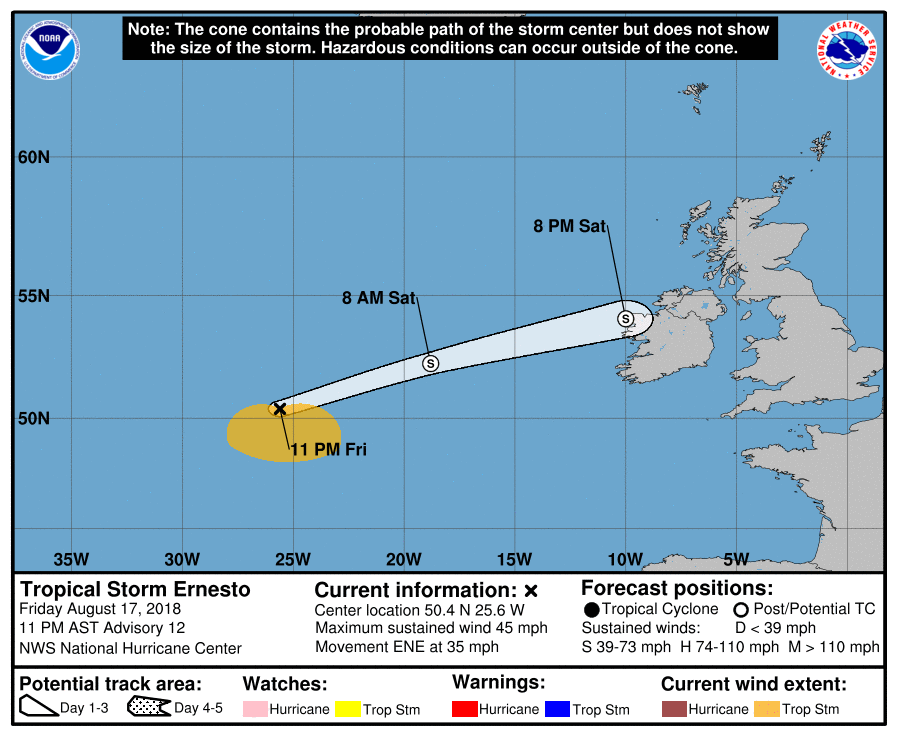
Not something you often see, the U.S. National Hurricane Center tracking a ex-tropical storm toward the UK and Ireland.
For now, a wavering weather front will straddle the north of Britain today, bringing thicker cloud and patchy outbreaks of rain across central and southern Scotland, Northern Ireland and much of northern England through the day. Breezy here too. To the north of the front, northern Scotland will see brighter skies, but it will be windy - with a scattering of showers towards the west. To the south of the front we are in a humid southwesterly flow across the rest of England and Wales, so it will often be rather cloudy, particularly in the morning. The cloud persisting in the west – thick enough to bring some drizzle over western hills, but across central and eastern areas of England it will stay dry and the cloud will thin and break in places to allow some warm sunny spells this afternoon.
Where the sun appears across central and eastern England, we could see temperatures reach 22-25C, generally away from northern Scotland, where it will be cooler and fresher to the north of that front, temperatures reaching 17-21C – despite the cloud.
Then the low formally known as Ernesto arrives across Ireland and Northern Ireland this evening, bringing with it steady outbreaks of heavy rain accompanied by gusty winds around coasts, the rain then quickly spreading east across central and southern Scotland, northern England and Wales in the early hours. Dry across southern England and northern Scotland. A warm and muggy but breezy night across England and Wales.
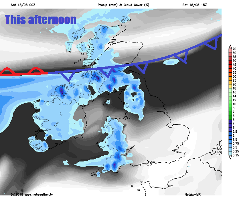
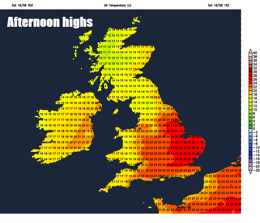
Away from northern Scotland, a wet start across the north, rain heavy across the west, before the early persistent rain quickly clears in the morning, but leaving a legacy of cloudy skies with the odd patch of drizzle or light rain across southern Scotland, Northern Ireland, England and Wales through much of the day. Northern Scotland bright or sunny and staying mostly dry. A mostly dry day across the south, but fairly windy in the morning across England and Wales, before winds ease into the afternoon. As it will be rather cloudy across many areas tomorrow, so temperatures will be supressed, reaching 19-22C across England, Wales and Northern Ireland, 15-17C across Scotland. It will feel humid though in the south.
The flow still coming in off the Atlantic on Monday, so a fair bit of cloud around for many, thick enough to bring some scattered showers in places – especially in the west. Where the cloud thins and breaks across southern, central and eastern England – temperatures could reach 24-26C. Elsewhere temperatures reaching 17-21C. Humid, despite the cloud.
Tuesday is looking largely dry with sunny spells across England and Wales, after a dry and bright start – thicker cloud and outbreaks of rain will spread in off the Atlantic across Northern Ireland and Scotland through the day.
On Wednesday perhaps cloudy with rain returning for a time across the north, drier, brighter and feeling warm in the south. Some uncertainty later in the week, but we may see a band of rain spread southeast across England and Wales on Thursday, followed by a cooler and fresher northwesterly flow into Friday, with showers across the north and west, drier towards the south and east.


