


Saturday staying mostly fine and sunny, rain moving into the southwest spreading across all parts tonight and through Sunday.

Friday saw some heavy thundery downpours affect many areas, particularly so across parts of Wales and southern England, with Herstmonceux in East Sussex recording just shy of 50mm or 2 inches of rain in 24 hours, not far off a month’s rainfall for the area. Although Saturday will be mostly dry and sunny, rain already arriving in the southwest will spread across many parts tonight and through Sunday, the rain heavy and thundery in places, so it could be a wash out for some outdoor plans tomorrow. Next week will start showery on Monday, but gradually southern areas will generally become drier and increasingly warmer and sunnier for most of the week, while the north sees cooler, breezier and more changeable conditions with rain at times.
For now, it’s a chilly start for many, the temperature fell as low as 3C in a number of more rural spots across the north and west this morning and even on the usually balmy south coast the temperature fell to 5.4C at Bournemouth Airport, but there is plenty of sunshine around meaning it will soon warm up.

For the vast majority of the UK it will be a fine and sunny morning and for northern and eastern areas the sunshine will continue into the afternoon. However, across the SW of England and south Wales it is cloudier with outbreaks of mainly light rain already moving in from the southwest, the cloudier skies gradually spreading north and east across Wales, Northern Ireland, the Midlands and southern England through the day, with some patchy rain or drizzle following by evening. But for much of Scotland and eastern England it will stay dry and sunny today. It should stay mostly dry, until late afternoon at least, for day 3 of the England v India Second Test Cricket at Lord’s in London.
.png)
Temperatures pegged back as the wind picks up under the cloudier skies with rain across the southwest and west this afternoon, reaching 18-19C. Where we see the sunnier skies across northern and eastern England, temperatures reaching 20-23C. Across Scotland reaching 15-18C.
Cloudy skies and widespread outbreaks of rain spreading north and east across England, Wales and Northern Ireland this evening, reaching southern Scotland in the early hours, the rain turning heavy through the night from the southwest across SW England, Wales, NW England and eventually SW Scotland by the end of the night, with a risk of thunder too. Northern Scotland perhaps escaping with a dry night but chilly under clear spells.
Perhaps off to a bright but chilly start across northern Scotland and perhaps bright and dry across the far southeast of England, but otherwise much of the UK will start Sunday cloudy with outbreaks of rain – which will be heavy and perhaps thundery across central and western areas. The rain will gradually ease eastwards and northwards across Scotland, England and Wales through the day, followed by brighter conditions but also heavy and perhaps thundery showers across the west, further heavy and perhaps thundery bursts of rain may push up from the south across southern and eastern England in the afternoon and evening. Quite a warm and humid feel, despite the rain around, temperatures reaching 20-22C widely away from the far north.
A shallow area of low pressure will move east out over the North Sea on Monday, so the day will start with showers across many areas, before they become confined to the east in the afternoon – where they may turn heavy and thundery. Ridge of high pressure building to the west will mean western counties dry out in the afternoon - with more in the more in the way of sunshine. Temperatures reaching 18C in the north to 23C in the south.
Tuesday looks to start mostly dry and bright before cloud and patchy rain move in across Scotland and N. Ireland – where it will be a cool and breezy day too. However, much of England and Wales away from the NW look to remain dry and bright or sunny, warmer in the south with 25C possible in the southeast.
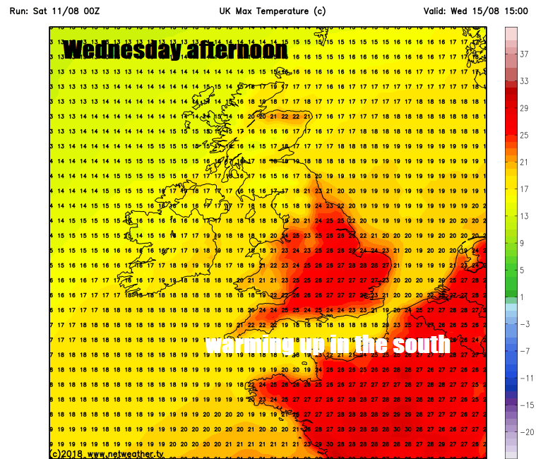
Wednesday looks to stay mostly dry and fine across southern, central and eastern England – where temperatures may reach 25-27C, turning windy and cooler with outbreaks of rain spreading in across the north and west through the day.
A weakening band of rain reaching the southeast on Thursday, before clearing in the afternoon, sunny but breezy conditions following, showers affecting the northwest. England and Wales looking mostly dry on Friday, showery rain may affect Scotland, westerly breeze across most parts means it be cool in the north and not particularly hot in the south either, though could reach mid-20s Celsius in the southeast.


