The whole country is now into fresher air, with a scattering of showers and sunny spells. The remainder of the week continues in similar style, but low pressure arrives to bring some wind and rain for the weekend.
And that's that, with some sharp showers and crashes of thunder, the heatwave drew to a close overnight, as the last of the real heat moved away from southeast England. Today will see temperatures much closer to normal just about everywhere, although East Anglia and the southeast will still see temperatures of 23-25c - that sounds warm enough, but is still some 7-8c down on yesterday.
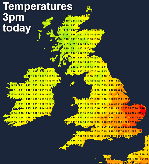
With the fresher temperatures, we also have some showers around today. These will mostly be in the north and west of the country, but a few will make it over into central and eastern parts. Southeast England is best placed to avoid them altogether, but regardless of the shower risk, many places will stay dry with plenty of sunshine.
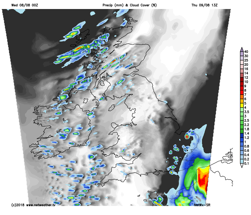
A fresh night follows, with temperatures dipping into single figures quite widely, away from the southeast quarter of Britain. There'll still be some showers dotted about, especially in the west, but most regions will be dry.
Tomorrow then brings a very similar day to today. There'll be a good scattering of showers, these mostly affecting western parts to leave most parts enjoying sunny spells. One thing we'll have to keep an eye on though is a low pressure system running up through France and into the Low Countries. That'll bring the threat of some rain - perhaps thundery, up toward southeast England and East Anglia from the morning onwards.
 Friday brings another day of sunny spells and some showers, still mainly in the west. Changes will be afoot though, as low pressure starts to make a move in from the Atlantic, ready for a wet, windy start to the weekend in many parts. It does look increasingly likely that the southeast quarter of the country will miss out on the bulk of the rain though, with some increasingly hot, humid air potentially making a short comeback.
For most, Saturday will bring a spell of rain, moving west to east on blustery winds. Followed by a few breaks in the cloud, but also a good few showers. That southeast corner is set to stay clear of trouble though, with temperatures heading toward the mid, maybe even high twenties by Sunday.
The warm front associated with the low will have brought Saturday's rain, by Sunday it's the turn of the cold front to deliver another batch, clearing away the humid air behind it, as winds swing away from southerlies, initially into the southwest, then by Monday, west or northwest as the weekend low moves out into the North Sea.